
Edgeøya, occasionally anglicised as Edge Island, is a Norwegian island located in southeast of the Svalbard archipelago; with an area of 5,073 square kilometres (1,960 sq mi), it is the third largest island in this archipelago. An Arctic island, it forms part of the Søraust-Svalbard Nature Reserve, home to polar bears and reindeer. Its eastern side is covered by an ice field. The island is named after Thomas Edge, an English merchant and whaler. It is seldom visited today.

Van Mijenfjorden is the third-longest fjord in Norway's Svalbard archipelago. It lies in the southern portion of Spitsbergen island, south of Nordenskiöld Land and north of Nathorst Land. The fjord is 83 km (52 mi) long, being separated from Bellsund further out by Akseløya and Mariaholmen. The settlement of Sveagruva lies on the fjord's north bank.

Storfjorden is the body of water separating Spitsbergen in the west from Barentsøya and Edgeøya to the east. Its southern limits are Kikutodden in Sørkapp Land east to Håøya, Tiholmane, Brækmoholmane, and Menkeøyane in Thousand Islands and northeast to Negerpynten—the southeastern promontory of Edgeøya. Its limits on its eastern side are Sundneset on the northern side of Freemansundet south to Palibinramten on the northwest coast of Edgeøya. The northern part is called Ginevra Bay, which lies between Olav V Land and Barentsøya. It ends at Heleysundet.

Thousand Islands is a group of small islands south of Edgeøya. They form part of the Svalbard archipelago. The group consists of over forty islands and islets, including Brotskjer, Kulstadholmane, Utsira, Tufsen, Kong Ludvigøyane, Bölscheøya, Hornøya, Tiholmane, Meinickeøyane, Sletteøya, Schareholmane, Skråholmen, Brækmoholmane, Tareloppa, Vindholmen, and Menkeøyane.
Bölscheøya is an island southwest of Negerpynten, the southeastern point of Edgeøya. It is part of Thousand Islands. The island was named in 1868 by the German geographer August Petermann (1822–78) after the German journalist Carl Bölsche, father of the German writer and zoologist Wilhelm Bölsche (1843–93). The remains of a whaling station from the 17th century can be found on the island.
Meinickeøyane is an island group composed of two islets, Store Meinickeøya and Vesle Meinickeøya, that form part of Thousand Islands, an island group south of Edgeøya, part of the Svalbard archipelago. They were named after the German geographer Carl Eduard Meinicke (1803–76).
Vindholmen is a small islet southeast of Brækmoholmane, part of Thousand Islands, an island group south of Edgeøya.
Arendtsøya is a small island in Kong Ludvigøyane, part of Thousand Islands, an island group south of Edgeøya. The island is named after the German geographer Karl Arendts (1815–81).
Bruhnsøya is a small island in Kong Ludvigøyane, an island group in Thousand Islands, an archipelago south of Edgeøya. The island is named after the German astronomer Carl Christian Bruhns (1830–81).
Islomen is a small rocky island, or skerry, in the southeastern part of Menkeøyane, part of Thousand Islands, a Norwegian archipelago south of Edgeøya.
Blåmåken is the northeasternmost island in Menkeøyane, part of Thousand Islands, a Norwegian archipelago south of Edgeøya.
Havella is the largest islet in Menkeøyane, part of Thousand Islands, a Norwegian archipelago south of Edgeøya. It is named after the long-tailed duck, a migrant to Svalbard.
Zieglerøya is an island off the headland Andréetangen at the eastern side of Tjuvfjorden, at the southern side of Edgeøya, Svalbard. Total area of the island is approximately 2,8 km2. The island is possibly named after either German Arctic explorer Phil. Alex. Ziegler, or Swiss cartographer Jakob Melchior Ziegler.
Andréetangen is a headland at the eastern side of Tjuvfjorden at Edgeøya, Svalbard. The headland is named after German geographer Karl Andrée. Off the headland are the two islands Zieglerøya and Delitschøya.
Delitschøya is an island off Andréetangen at the eastern side of Tjuvfjorden, at Edgeøya, Svalbard. It is located nearby the island Zieglerøya. The island is named after geographer Otto Delitsch.
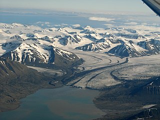
Bakaninbreen is a glacier in Heer Land at Spitsbergen, Svalbard. It has a length of about 9.5 kilometers, and merges with the glacier of Paulabreen. The glacier is named after a member of the Swedish-Russian Arc-of-Meridian Expedition. The mountain of Hollertoppen is located between Bakaninbreen and Ragna-Mariebreen.
Dunøysundet is a bay in the Norwegian archipelago of Svalbard. It is located near many other bays such as Nottinghambukta and is located relatively close to Longyearbyen. Most of the islands to the west of it are located within the Dunøyane Bird Sanctuary.

