Jan Mayen is a Norwegian volcanic island situated in the Arctic Ocean. It is 55 km (34 mi) long (southwest-northeast) and 373 km2 (144 sq mi) in area, partly covered by glaciers. It has two parts: larger northeast Nord-Jan and smaller Sør-Jan, linked by a 2.5 km (1.6 mi) wide isthmus. It lies 600 km (370 mi) northeast of Iceland, 500 km (310 mi) east of central Greenland and 1,000 km (620 mi) west of the North Cape, Norway. The island is mountainous, the highest summit being the Beerenberg volcano in the north. The isthmus is the location of the two largest lakes of the island, Sørlaguna, and Nordlaguna. A third lake is called Ullerenglaguna. Jan Mayen was formed by the Jan Mayen hotspot.
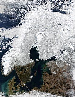
Scandinavia is a region in Northern Europe, with strong historical, cultural, and linguistic ties. The term Scandinavia in local usage covers the three kingdoms of Denmark, Norway, and Sweden. The majority national languages of these three, belong to the Scandinavian dialect continuum, and are mutually intelligible North Germanic languages. In English usage, Scandinavia also sometimes refers to the Scandinavian Peninsula, or to the broader region including Finland and Iceland, which is always known locally as the Nordic countries.

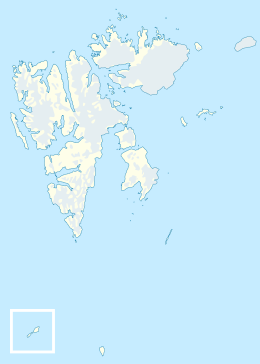
Svalbard is a Norwegian archipelago in the Arctic Ocean. Situated north of mainland Europe, it is about midway between continental Norway and the North Pole. The islands of the group range from 74° to 81° north latitude, and from 10° to 35° east longitude. The largest island is Spitsbergen, followed by Nordaustlandet and Edgeøya. Administratively, the archipelago is not part of any Norwegian county, but forms an unincorporated area administered by a governor appointed by the Norwegian government. Since 2002, Svalbard's main settlement, Longyearbyen, has had an elected local government, somewhat similar to mainland municipalities. Other settlements include the Russian mining community of Barentsburg, the research station of Ny-Ålesund, and the mining outpost of Sveagruva. Ny-Ålesund is the northernmost settlement in the world with a permanent civilian population. Other settlements are farther north, but are populated only by rotating groups of researchers.
Shetland, also called the Shetland Islands and formerly Zetland, is a subarctic archipelago of Scotland that lies northeast of the mainland of Scotland.

Kristiansund[krɪstjɑnˈsʉnː](listen) is a city and municipality on the western coast of Norway in the Nordmøre district of Møre og Romsdal county. It was officially awarded township status in 1742, and it is still the major town for the region. The administrative center of the municipality is the city of Kristiansund. Other settlements in the municipality include the villages of Kvalvåg, Rensvik, and Nedre Frei.

Geologically, a fjord or fiord is a long, narrow inlet with steep sides or cliffs, created by a glacier. There are many fjords on the coasts of Alaska, Antarctica, British Columbia, Chile, Greenland, the Faroe Islands, Iceland, Kamchatka, the Kerguelen Islands, New Zealand, Norway, Novaya Zemlya, Labrador, Nunavut, Newfoundland, Quebec, Scotland, South Georgia Island, and Washington state. Norway's coastline is estimated at 29,000 kilometres (18,000 mi) with nearly 1,200 fjords, but only 2,500 kilometres (1,600 mi) when fjords are excluded.
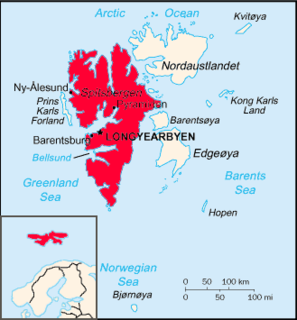
Spitsbergen is the largest and only permanently populated island of the Svalbard archipelago in northern Norway. Constituting the westernmost bulk of the archipelago, it borders the Arctic Ocean, the Norwegian Sea, and the Greenland Sea. Spitsbergen covers an area of 37,673 km2 (14,546 sq mi), making it the largest island in Norway and the 36th-largest in the world. The administrative centre is Longyearbyen. Other settlements, in addition to research outposts, are the Russian mining community of Barentsburg, the research community of Ny-Ålesund, and the mining outpost of Sveagruva. Spitsbergen was covered in 21,977 km2 (8,485 sq mi) of ice in 1999, which was approximately 58.5% of the island's total area.

Sogn og Fjordane is a county in western Norway, bordering Møre og Romsdal, Oppland, Buskerud, and Hordaland. The county administration is in the village of Hermansverk in Leikanger municipality. The largest town in the county is Førde.

Troms (pronounced [trʊms] or Romsa or Tromssa is a county in northern Norway. It borders Finnmark county to the northeast and Nordland county in the southwest. Norrbotten Län in Sweden is located to the south and further southeast is a shorter border with Lapland Province in Finland. To the west is the Norwegian Sea.

Peter I Island is an uninhabited volcanic island in the Bellingshausen Sea, 450 kilometres (280 mi) from continental Antarctica. It is claimed as a dependency of Norway, and along with Bouvet Island and Queen Maud Land comprises one of the three Norwegian dependent territories in the Antarctic and Subantarctic. Peter I Island is 11 by 19 kilometres long and 156 square kilometres (60 sq mi), slightly larger than Staten Island as an example. The tallest peak is the ultra and 1,640-meter (5,380 ft) tall Lars Christensen Peak. Nearly all of the island is covered by a glacier and it is surrounded most of the year by pack ice, making it inaccessible during these times. There is little vertebrate animal life on the island apart from some seabirds and seals.

Hitra is a municipality in Trøndelag county, Norway. The municipality covers the island of Hitra and hundreds smaller islands, islets, and skerries. It is part of the Fosen region. The administrative centre of the municipality is the village of Fillan. Other villages include Andersskogan, Ansnes, Forsnes, Hestvika, Knarrlagsund, Kvenvær, Melandsjøen, Nordbotn, Sandstad, and Ulvan.

Frøya is the westernmost municipality in Trøndelag county, Norway. It is part of the Fosen region and consists of the island of Frøya, which lies north of the island of Hitra, as well several thousand other small islands surrounding the island of Frøya. The village of Sistranda is the administrative center of Frøya. Other villages include Hammarvika, Titran, Sula, and Mausund. The main island of Frøya is connected to the neighboring island of Hitra by the Frøya Tunnel which goes under the Frøyfjorden.

Andøy is the northernmost municipality in Nordland county, Norway. It is part of the Vesterålen archipelago. The main island in the municipality is Andøya. The administrative centre of the municipality is the village of Andenes. Other villages in the municipality include Bjørnskinn, Bleik, Dverberg, Fiskenes, Fornes, Nordmela, Risøyhamn, Skarstein, Å, Åknes, and Åse.
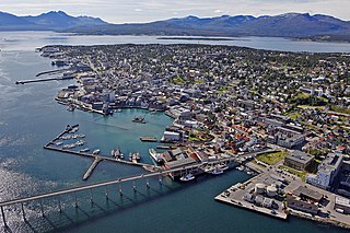
Tromsø is a municipality in Troms county, Norway. The administrative centre of the municipality is the city of Tromsø. Outside Norway, Tromso and Tromsö are alternative spellings of the name.

Lofoten is an archipelago and a traditional district in the county of Nordland, Norway. Lofoten is known for a distinctive scenery with dramatic mountains and peaks, open sea and sheltered bays, beaches and untouched lands. Though lying within the Arctic Circle, the archipelago experiences one of the world's largest elevated temperature anomalies relative to its high latitude.
The Sverdrup Islands is an archipelago of the northern Queen Elizabeth Islands, in Nunavut, Canada. The islands are situated in the Arctic Ocean, west of Ellesmere Island from 77° to 81° North and 85° to 106° West.

The Svalbard Treaty recognises the sovereignty of Norway over the Arctic archipelago of Svalbard, at the time called Spitsbergen. The exercise of sovereignty is, however, subject to certain stipulations, and not all Norwegian law applies. The treaty regulates the demilitarisation of the archipelago. The signatories were given equal rights to engage in commercial activities on the islands. As of 2012, Norway and Russia are making use of this right.

Faroese people or Faroe Islanders are a North Germanic ethnic group and nation native to the Faroe Islands. The Faroese are of mixed Norse and Gaelic origins. About 21,000 Faroese live in neighbouring countries, particularly in Denmark, Iceland and Norway. Most Faroese are citizens of the Kingdom of Denmark, in which the Faroe Islands are a constituent nation. The Faroese language is one of the North Germanic languages and is closely related to Icelandic and to western Norwegian varieties.

Kvitøya is an island in the Svalbard archipelago in the Arctic Ocean, with an area of 682 square kilometres (263 sq mi). It is the easternmost part of the Kingdom of Norway. The closest Russian Arctic possession, Victoria Island, lies only 62 kilometres (39 mi) to the east of Kvitøya.
Bouvet Island is an uninhabited subantarctic high island and dependency of Norway located in the South Atlantic Ocean at 54°25′S3°22′E, thus locating it north of and outside the Antarctic Treaty System. It lies at the southern end of the Mid-Atlantic Ridge and is the most remote island in the world, approximately 1,700 kilometres (1,100 mi) north of the Princess Astrid Coast of Queen Maud Land, Antarctica, 1,160 kilometres (720 mi) east of the South Sandwich Islands and 2,600 kilometres (1,600 mi) south-southwest of the coast of South Africa.