Related Research Articles

Jan Mayen is a Norwegian volcanic island in the Arctic Ocean, with no permanent population. It is 55 km (34 mi) long (southwest-northeast) and 373 km2 (144 sq mi) in area, partly covered by glaciers [an area of 114.2 km2 (44.1 sq mi) around the Beerenberg volcano. It has two parts: larger northeast Nord-Jan and smaller Sør-Jan, linked by a 2.5 km (1.6 mi) wide isthmus. It lies 600 km (370 mi) northeast of Iceland, 500 km (310 mi) east of central Greenland and 1,000 km (620 mi) west of the North Cape, Norway. The island is mountainous, the highest summit being the Beerenberg volcano in the north. The isthmus is the location of the two largest lakes of the island, Sørlaguna, and Nordlaguna. A third lake is called Ullerenglaguna. Jan Mayen was formed by the Jan Mayen hotspot.

Henry Hudson was an English sea explorer and navigator during the early 17th century, best known for his explorations of present-day Canada and parts of the northeastern United States.

The maritime European exploration of Australia consisted of several waves of European seafarers who sailed the edges of the Australian continent. Dutch navigators were the first Europeans known to have explored and mapped the Australian coastline. The first documented encounter was that of Dutch navigator Willem Janszoon, in 1606. Dutch seafarers also visited the west and north coasts of the continent, as did French explorers.

Willem Cornelisz Schouten was a Dutch navigator for the Dutch East India Company. He was the first to sail the Cape Horn route to the Pacific Ocean.
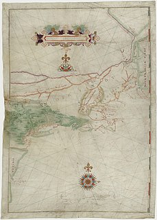
Adriaen (Arjan) Block was a Dutch private trader, privateer, and ship's captain who is best known for exploring the coastal and river valley areas between present-day New Jersey and Massachusetts during four voyages from 1611 to 1614, following the 1609 expedition by Henry Hudson. He is noted for possibly having named Block Island, Rhode Island, and establishing early trade with the Native Americans, and for the 1614 map of his last voyage on which many features of the mid-Atlantic region appear for the first time, and on which the term New Netherland is first applied to the region. He is credited with being the first European to enter Long Island Sound and the Connecticut River, and to determine that Manhattan and Long Island are islands.

Smeerenburg was a whaling settlement on Amsterdam Island in northwest Svalbard. It was founded by the Danish and Dutch in 1619 as one of Europe's northernmost outposts. With the local bowhead whale population soon decimated and whaling developed into a pelagic industry, Smeerenburg was abandoned about 1660.
Willem Janszoon, sometimes abbreviated to Willem Jansz., was a Dutch navigator and colonial governor. Janszoon served in the Dutch East Indies in the periods 1603–1611 and 1612–1616, including as governor of Fort Henricus on the island of Solor. He is the first European known to have seen the coast of Australia during his voyage of 1605–1606.
The polar archipelago of Svalbard was first discovered by Willem Barentsz in 1596, although there is disputed evidence of use by Pomors or Norsemen. Whaling for bowhead whales started in 1611, dominated by English and Dutch companies, though other countries participated. At that time there was no agreement about sovereignty. Whaling stations, the largest being Smeerenburg, were built during the 17th century, but gradually whaling decreased. Hunting was carried out from the 17th century by Pomors, but from the 19th century it became more dominated by Norwegians.

Edgeøya, occasionally anglicised as Edge Island, is a Norwegian island located in southeast of the Svalbard archipelago; with an area of 5,073 square kilometres (1,960 sq mi), it is the third-largest island in this archipelago. An Arctic island, it forms part of the Søraust-Svalbard Nature Reserve, home to polar bears and reindeer. An ice field covers its eastern side. The island takes its name from Thomas Edge, an English merchant and whaler. It is seldom visited today.
Jan Jacobszoon May van Schellinkhout was a Dutch seafarer and explorer.
Thomas Marmaduke was an English explorer, sealer, and whaler in the early 17th century.

Fairhaven is an area of Norway. Generally speaking, it is the area between Amsterdam Island and Danes Island and the mainland, while specifically it refers to the sound between Danes Island and the mainland, in particular the strait between Moseøya and Danes Island. The modern name for this area is Smeerenburgfjorden.

Caert van't Landt van d'Eendracht is a 1627 map by Hessel Gerritsz. One of the earliest maps of Australia, it shows what little was then known of the west coast, based on a number of voyages beginning with the 1616 voyage of Dirk Hartog, when he named Eendrachtsland after his ship.

Ytre Norskøya is an island on the northwest coast of Spitsbergen, part of the Svalbard archipelago.
Magdalenefjorden is an 8 km long and up to 5 km wide fjord between Reuschhalvøya and Hoelhalvøya, Albert I Land, on the west coast of Spitsbergen, the largest island in the Svalbard archipelago. It is large enough to accommodate even the largest of cruise ships which are even able to turn through 180 degrees in the fjord. On the south shore of the fjord is the bay Gullybukta.
Thomas Edge was an English merchant, whaler, and sealer who worked for the Muscovy Company in the first quarter of the 17th century. The son of Ellis Edge, Thomas Edge was born in the parish of Blackburn in Lancashire in 1587/88. Edgeøya takes its name from him. Edge's Point, the eastern point of Recherche Fjord, also commemorated his name, but is now known as Lægerneset.

Farthest North describes the most northerly latitude reached by explorers, before the first successful expedition to the North Pole rendered the expression obsolete. The Arctic polar regions are much more accessible than those of the Antarctic, as continental land masses extend to high latitudes and sea voyages to the regions are relatively short.
Jean Vrolicq was a mariner from St-Jean-de-Luz in the first half of the 17th century. He served in the Danish, Dutch, and French whaling industries from 1619 to 1636, and later became a privateer.

The Noordsche Compagnie was a Dutch cartel in the whaling trade, founded by several cities in the Netherlands in 1614 and operating until 1642. Soon after its founding, it became entangled in territorial conflicts with England, Denmark, France, and other groups within the Netherlands.
Virgohamna is a small bay on the northern coast of Danes Island, an island off the northwestern coast of Spitsbergen. Spitsbergen and Danes Island are islands of the Svalbard archipelago. The bay is named after SS Virgo, the vessel of Swedish engineer and explorer Salomon August Andrée's 1896 expedition. Virgohamna is located across a small strait from Smeerenburg, a historical whaling station on Amsterdam Island about 2 km to the north.
References
- ↑ Schilder, Günter. (2005). Mr. Joris Carolus (ca. 1566 - ca. 1636) 'Stierman ende caertschryver tot Enchuysen', in: Daalder, R.; Loomeijer, F.R. et al. (Ed.) (2005). Koersvast: vijf eeuwen navigatie op zee, Zaltbommel, The Netherlands. ISBN 90-5994-108-X ; pp. 46–59 (Dutch)
- ↑ Holland, Clive (1994). Arctic Exploration and Development, c. 500 B.C. to 1915: an encyclopedia. New York: Garland.
- ↑ Hart, S. De eerste Nederlandse tochten ter walvisvaart (1957), p. 50. Hart says it occurred in 1613.
- Günter Schilder (1984) Development and Achievements of Dutch Northern and Arctic Cartography in the Sixteenth and Seventeenth Centuries, in Arctic Vol. 37, No. 4, December 1984.
- Conway, Martin (June 1901). "Joris Carolus, Discoverer of Edge Island". Geographical Journal . 17 (6): 623–632. doi:10.2307/1775214. JSTOR 1775214.
- Conway, William Martin (1906). No Man's Land: A History of Spitsbergen from Its Discovery in 1596 to the Beginning of the Scientific Exploration of the Country. Cambridge, At the University Press.
- Heawood, Edward (July 1906). "Correspondence—Joris Carolus and Edge Island". Geographical Journal . 28 (2): 189–190. doi:10.2307/1776105. JSTOR 1776105 . Retrieved 2009-11-21.
| General | |
|---|---|
| National libraries | |
| Biographical dictionaries | |
| Other | |