
Nathorst Land is the land area between Van Keulenfjorden and Van Mijenfjorden on Spitsbergen, Svalbard. [1]
The area is named after Alfred Gabriel Nathorst. [2]
The Aspelintoppen mountain is the highest peak in Nathorst Land. [3]
Nathorst Land is the land area between Van Keulenfjorden and Van Mijenfjorden on Spitsbergen, Svalbard. [1]
The area is named after Alfred Gabriel Nathorst. [2]
The Aspelintoppen mountain is the highest peak in Nathorst Land. [3]

Van Mijenfjorden is the third-longest fjord in Norway's Svalbard archipelago. It lies in the southern portion of Spitsbergen island, south of Nordenskiöld Land and north of Nathorst Land. The fjord is 83 km (52 mi) long, being separated from Bellsund further out by Akseløya and Mariaholmen. The settlement of Sveagruva lies on the fjord's north bank.
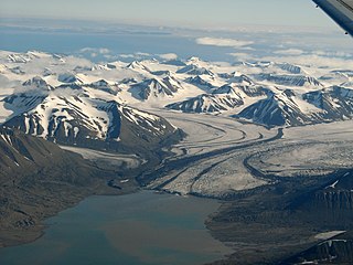
Aspelintoppen is the highest mountain of Nathorst Land at Spitsbergen, in the Norwegian archipelago of Svalbard. The mountain has a height of 1,221 m.a.s.l. and is located within Fagerstafjella, to the north of Nobeltoppen. It is named after Swedish industrialist Christian Henrik Thomas Aspelin.
Fagerstafjella is a mountain group in Nathorst Land at Spitsbergen, Svalbard. The group is located south of Van Mijenfjorden, between Scheelebreen and Danzigdalen. The highest mountain in the group is Aspelintoppen, which is also the highest mountain in Nathorst Land.
Danzigdalen is a valley in Nathorst Land at Spitsbergen, Svalbard. It is located south of Van Mijenfjorden, extending northwards from Svalbreen to Danzigøyra, with a total length of about 11.5 kilometers. At the western side of the valley are the mountains of Lundgrenfjellet and Vengefjellet, and to the east are Fagerstafjella.
Bravaisberget is a mountain in Nathorst Land on the island of Spitsbergen in the Norwegian archipelago of Svalbard. It reaches a height of 775 m.a.s.l., and is located at the mouth of Van Keulenfjorden. The mountain is named after French physicist Auguste Bravais, member of the 1838 Spitsbergen expedition with La Recherche.
Hisingerfjellet is a mountain in Nathorst Land at Spitsbergen, Svalbard. It has two peaks with heights of 1,078 and 1.044 m.a.s.l., respectively. The mountain is located between Krylbreen, Krylen, Breskarvet and Bromelldalen, at the southern side of Van Mijenfjorden. It is named after Swedish geologist Wilhelm Hisinger.
Bromelldalen is a valley in Nathorst Land at Spitsbergen, Svalbard. It has a length of about eight kilometers, and is located between the mountains of Sven Nilssonfjellet and Bassøefjellet on the eastern side, and Hisingerfjellet to the west, at the southern side of Van Mijenfjorden. The valley is named after Swedish botanist Olof Bromelius.
Sven Nilssonfjellet is a mountain in Nathorst Land at Spitsbergen, Svalbard. It has a height of 988 m.a.s.l. The mountain is named after Swedish zoologist Sven Nilsson. It is located west of Langlidalen and Langlifjellet, and north of Løyndbreen, at the southern side of Van Mijenfjorden. East of the mountain is the valley of Bromelldalen.
Bassøefjellet is a mountain in Nathorst Land at Spitsbergen, Svalbard. It has peaks with heights of 1,081 and 953 m.a.s.l. respectively. The mountain is named after Norwegian civil servant and Governor of Svalbard, Johannes Gerckens Bassøe. It is located between Van Mijenfjorden and Van Keulenfjorden, west of Langlifjellet and south of Løyndbreen, with the glaciers of Lundbreen and Kvitskarvbreen to the south. East of the mountain is the valley of Bromelldalen.
Langlifjellet is a mountain in Nathorst Land at Spitsbergen, Svalbard. It has peaks with heights of 1,011, 973 and 885 m.a.s.l. respectively. The mountain is surrounded by the mountains of Sven Nilssonfjellet, Bassøefjellet, and Steindolptoppen, and the glaciers of Løyndbreen, Lundbreen and Langlibreen. The valley of Langlidalen separates Langlifjellet and Sven Nilssonfjellet from the mountain of Rånekampen.
Rånekampen is a mountain in Nathorst Land at Spitsbergen, Svalbard. It has a height of 1,185 m.a.s.l. The mountain is located south of Van Mijenfjorden, and is surrounded by the mountains of Vengefjellet, Lundgrenfjellet and Steindolptoppen, and the glaciers of Langlibreen, Steindolpbreen, Vengebreen, and Rånebreen. The valley of Langlidalen separates Rånekampen from the mountains of Langlifjellet and Sven Nilssonfjellet.
Lundgrenfjellet is a mountain in Nathorst Land at Spitsbergen, Svalbard. It has a height of 1,054 m.a.s.l., and is named after Swedish geologist Sven Anders Bernhard Lundgren. The mountain is located south of Van Mijenfjorden, north of the glaciers of Vengebreen and Rånebreen, west of the valley of Danzigdalen.
Paulabreen is a glacier in Nathorst Land and Heer Land at Spitsbergen, Svalbard. It has a length of about fifteen kilometers, extending from the mountain of Kjølberget to the bay of Rindersbukta. The glacier is named after Paula, the wife of shipmaster Richard Ritter von Barry. Paulabreen borders to the mountain area of Vriompeisen, and the mountain of Hollertoppen. A tributary glacier is Bakaninbreen.
Rindersbukta is a bay in Nathorst Land and Heer Land at Spitsbergen, Svalbard. It forms the southern branch of Van Mijenfjorden. The glaciers of Scheelebreen and Paulabreen debouche into the bay. The bay is named after Dutch whaler Michiel Rinders.
Brogniartfjella is a mountain ridge in Nathorst Land at Spitsbergen, Svalbard. The ridge is located at the north side of Van Keulenfjorden. It has a length of about eight kilometers, and its highest peak is 904 m.a.s.l. The ridge is named after French paleontologist Adolphe-Théodore Brongniart. First known ascent dates from 1920. The valley of Wittrockdalen separates Brogniartfjella from Wittrockfjellet.
Davisdalen is a valley in Nathorst Land at Spitsbergen, Svalbard. It is named after American geomorphologist William Morris Davis. The valley has a length of about 5.5 kilometers, extending from the mountain ridge of Mjellegga southwards down to Davisodden, at the northern side of Van Keulenfjorden. A tributary valley to Davisdalen is Wittrockdalen.
Mjellegga is a mountain ridge in Nathorst Land at Spitsbergen, Svalbard. It has a length of about 3.5 kilometers, and its highest peak is 785 m.a.s.l. Surrounding glaciers are Mjellfonna, Greenbreen and Martinbreen. The valley of Davisdalen extends from Mjellegga down to the headland of Davisodden, at the northern side of Van Keulenfjorden.
Törnbohmfjella is a mountain range in Nathorst Land at Spitsbergen, Svalbard. The range is named after the Swedish geologist Alfred Elis Törnebohm. It covers an area about nine kilometers long and six kilometers wide, bordering on Van Keulenfjorden, Davisdalen, Martinbreen, Richterbreen and Richterdalen. Its highest mountain peak is Såta, and it also comprises Pallfjellet, Kolthoffberget, Ekholmfjellet and Venetzhumpen. The glaciers of Charpentierbreen and Venetzbreen are located within the mountain range of Törnbohmfjella.
Frysjabreen is a glacier in Nathorst Land at Spitsbergen, Svalbard. It has a length of about six kilometers, and extends from the ridges of Breskarvet and Kjellmanberget down to the valley of Frysjadalen. The glacier is named after the river Frysja, which originates from Frysjabreen and flows through Frysjadalen until its outlet into Van Mijenfjorden.
Wittrockfjellet is a mountain in Nathorst Land at Spitsbergen, Svalbard. It is named after Swedish botanist Veit Brecher Wittrock. The mountain is located at the northern side of Van Keulenfjorden. It has a length of about 3.5 kilometers, and its highest peak is 931 m.a.s.l. The valley of Wittrockdalen separates Wittrockfjellet from the ridge of Brogniartfjella.
77°38′00″N16°12′15″E / 77.63333°N 16.20417°E
| | This Spitsbergen location article is a stub. You can help Wikipedia by expanding it. |