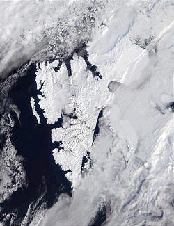
Svalbard is an archipelago in the Arctic Ocean roughly centered on 78° north latitude and 20° east longitude. The archipelago is the northernmost part of the Kingdom of Norway. The three main islands in the group consist of Spitsbergen, Nordaustlandet and Edgeøya. There are also a number of smaller islands, such as Barents Island (Barentsøya), Kvitøya, Prins Karls Forland, Kongsøya, Bear Island, Svenskøya, Wilhelm Island and other smaller islands or skerries.

Spitsbergen is the largest and the only permanently populated island of the Svalbard archipelago in northern Norway.
Smeerenburg was a whaling settlement on Amsterdam Island in northwest Svalbard. It was founded by the Danish and Dutch in 1619 as one of Europe's northernmost outposts. With the local bowhead whale population soon decimated and whaling developed into a pelagic industry, Smeerenburg was abandoned around 1660.
The polar archipelago of Svalbard was first discovered by Willem Barentsz in 1596, although there is disputed evidence of use by Pomors or Norsemen. Whaling for bowhead whales started in 1611, dominated by English and Dutch companies, though other countries participated. At that time there was no agreement about sovereignty. Whaling stations, the largest being Smeerenburg, were built during the 17th century, but gradually whaling decreased. Hunting was carried out from the 17th century by Pomors, but from the 19th century it became more dominated by Norwegians.
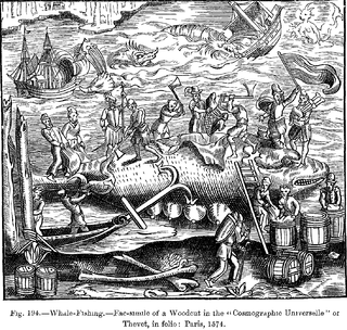
This article discusses the history of whaling from prehistoric times up to the commencement of the International Whaling Commission (IWC) moratorium on commercial whaling in 1986. Whaling has been an important subsistence and economic activity in multiple regions throughout human history. Commercial whaling dramatically reduced in importance during the 19th century due to the development of alternatives to whale oil for lighting, and the collapse in whale populations. Nevertheless, some nations continue to hunt whales even today.
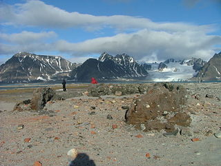
Nordvest-Spitsbergen National Park is located on the Norwegian arctic archipelago of Svalbard and includes parts of north-west Spitsbergen and nearby islands such as Danes Island and Moffen. It contains, among other things, warm springs and remains of volcanoes in Bockfjorden.

Walter E. Wellman was an American journalist, explorer, and aeronaut.

Danes Island is an island in Norway's Svalbard archipelago in the Arctic Ocean with an area of 40.6 km2 (15.7 sq mi). It lies just off the northwest coast of Spitsbergen, the largest island in the archipelago, near to Magdalenefjorden. Just to the north lies Amsterdam Island. Most of Svalbard's islands, including Danes Island, are uninhabited; only Spitsbergen, Bjørnøya and Hopen have settlements.

The America was a non-rigid airship built by Louis Mutin Godard in France in 1906 for the journalist Walter Wellman's attempt to reach the North Pole by air. Wellman first conceived of using a balloon to fly to the pole during a failed polar attempt by boat and sledge from Svalbard in 1894. He then visited Paris to review the state of balloon technology but left disappointed by the lack of acceptable steering and propulsion capability. A decade later while at the 1905 Portsmouth Peace Conference he learned of recent innovations in French dirigible design and believed a solution might be at hand for his Arctic aerial plan. After receiving the backing of newspaper publisher Victor F. Lawson, the Wellman Chicago Record-Herald Polar Expedition was announced, and Wellman traveled to Paris in search of a suitable design and manufacturer. In the meantime a public company was established to raise the $US 250,000 required for the expedition and airship.
Fairhaven is an area of Norway. Generally speaking, it is the area between Amsterdam Island and Danes Island and the mainland, while specifically it refers to the sound between Danes Island and the mainland, in particular the strait between Moseøya and Danes Island. The modern name for this area is Smeerenburgfjorden.

Ytre Norskøya is an island on the northwest coast of Spitsbergen, part of the Svalbard archipelago.
Magdalenefjorden is an 8 km long and up to 5 km wide fjord between Reuschhalvøya and Hoelhalvøya, Albert I Land, on the west coast of Spitsbergen, the largest island in the Svalbard archipelago. It is large enough to accommodate even the largest of cruise ships which are even able to turn through 180 degrees in the fjord. On the south shore of the fjord is the bay Gullybukta.
Amsterdam Island is a small island off the northwest coast of West-Spitsbergen. It is separated from Danes Island by the strait Danskegattet. Its total area is 16.8 km2. Its highest point is Hiertabreen, at 472 meters above sea level. The percentage of the island covered in ice is 11.5%.
Kobbefjorden is a small fjord on the west coast of Danes Island, on the northwestern coast of Spitsbergen, the largest island of the Svalbard archipelago. The fjord is about two miles (3.5 km) long and 1-1.2 miles (1.5–2 km) wide. It offers one of the best anchorages on Spitsbergen's northwest coast, "being sheltered from most winds and ice-free for much of the year." At the head of the fjord is a valley, Kobbefjorddalen, which leads to the east coast of Danes Island. Kobbefjorden's southwesternmost point is Luftskipodden. Sir Martin Conway, on his visit to Spitsbergen in 1896–97, described the fjord as having "ice-smoothed hills of [the] hardest rock."

Farthest North describes the most northerly latitude reached by explorers, before the first successful expedition to the North Pole rendered the expression obsolete. The Arctic polar regions are much more accessible than those of the Antarctic, as continental land masses extend to high latitudes and sea voyages to the regions are relatively short.
Hamburgbukta is a one-kilometer-long bay on the western side of Hoelhalvøya, Albert I Land, Spitsbergen in the Svalbard archipelago.
Jean Vrolicq was a mariner from St-Jean-de-Luz in the first half of the 17th century. He served in the Danish, Dutch, and French whaling industries from 1619 to 1636, and later became a privateer.

Engelskbukta is a broad, open bay mid-way up the west coast of the Norwegian island of Jan Mayen. It lies between Kapp Rudsen and Kvalrossen, comprising Kvalrossbukta and Tømmerbukta. Presumably this is where the English resorted to in 1616, when they sent their first whaling ships to the island. The Dutch whalers called it Noordbaai and used it for one of their two main whaling stations. In 1632 two Basque whaling ships plundered the station, causing the Dutch to send a wintering party of seven men in 1633–34. All perished.
The archaeology of Svalbard is the study of human activity in the northerly Arctic Ocean archipelago's past. The geography, environment and climate of Svalbard have resulted in exceptional preservation conditions. Archaeological fieldwork on Svalbard is both expensive and physically exhausting, but new technology and infrastructure has allowed easier access. This easier access has also resulted in more damage caused by tourists.
