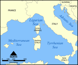
The Ligurian Sea is an arm of the Mediterranean Sea, between the Italian Riviera (Liguria) and the island of Corsica. The sea is theorized to be named after the ancient Ligures people.

Becicherecu-Mic is a commune in Romania, in Timiș County, Banat, near the city of Timișoara. It is composed of a single village, Becicherecu Mic. It also included Dudeștii Noi village until 2004, when it was split off to form a separate commune.

Louvaras is a village in the Troödos Mountains of Cyprus. The village is 28 kilometers north of Limassol. Of interest are the frescos in the small medieval church of St Mamas, built in 1455 in the centre of the village. The hamlet of Athrakos is part of the municipality.

Ágasegyháza is a village and municipality in Bács-Kiskun county, in the Southern Great Plain region of southern Hungary.

Suchedniów(listen) is a town in Skarżysko County, Świętokrzyskie Voivodeship, Poland, with 9,067 inhabitants (2004). It is the seat of the urban-rural district Gmina Suchedniów.

Matalebreras is a municipality located in the province of Soria, Castile and León, Spain. According to the 2004 census (INE), the municipality had a population of 118 inhabitants.

Hồng Ngự is a rural district of Đồng Tháp Province in the Mekong Delta region of Vietnam. As of 2009 the district had a population of 150,050. The district covers an area of 209.74 km². The district capital lies at Thường Thới Tiền Commune.
Văn Quan is a rural district of Lạng Sơn Province in the Northeast region of Vietnam. As of 2003 the district had a population of 57,050. The district covers an area of 549 km². The district capital lies at Văn Quan.

Kirano is a town and commune in Madagascar. It belongs to the district of Ambalavao, which is a part of Haute Matsiatra Region. The population of the commune was estimated to be approximately 13,000 in 2001 commune census.
Zielona is a village in the administrative district of Gmina Gródek, within Białystok County, Podlaskie Voivodeship, in north-eastern Poland, close to the border with Belarus. It lies approximately 13 kilometres (8 mi) south-east of Gródek and 46 km (29 mi) east of the regional capital Białystok.
Zelki Dąbrowe is a village in the administrative district of Gmina Karniewo, within Maków County, Masovian Voivodeship, in east-central Poland. It lies approximately 5 kilometres (3 mi) south-west of Maków Mazowiecki and 69 km (43 mi) north of Warsaw.
Grużajny is a village in the administrative district of Gmina Godkowo, within Elbląg County, Warmian-Masurian Voivodeship, in northern Poland. It lies approximately 29 kilometres (18 mi) east of Elbląg and 53 km (33 mi) north-west of the regional capital Olsztyn.
Vrátkov is a village and municipality in Kolín District in the Central Bohemian Region of the Czech Republic.
Oued Ellil is a town and commune in the Manouba Governorate, Tunisia. As of 2004 it had a population of 47,614.
Ostrovnoy, Ostrovnaya, or Ostrovnoye is the name of several inhabited localities in Russia:
Lemmikküla is a village in Lääne-Nigula Parish, Lääne County, in western Estonia.

Diplock Glacier is a narrow straight glacier, 10 miles (16 km) long, flowing eastward from Detroit Plateau, on Trinity Peninsula in Graham Land, into Prince Gustav Channel 5 miles (8 km) south of Alectoria Island. It is situated south of Marla Glacier and north of Zavera Snowfield. The feature was mapped from surveys by the Falkland Islands Dependencies Survey (1960–61), and was named by the UK Antarctic Place-Names Committee for Bramah Joseph Diplock, a British engineer who made considerable advances in the design of chain-track tractors (1885–1913).

Gunnestad Glacier is a glacier 13 nautical miles (24 km) long, flowing north between Mount Widerøe and Mount Walnum in the Sør Rondane Mountains of Antarctica. It was mapped by Norwegian cartographers in 1957 from air photos taken by U.S. Navy Operation Highjump, 1946–47, and named for Lieutenant Alf Gunnestad, a pilot with the Norwegian expedition under Lars Christensen, 1933–34.
Pantoja is a village in the province of Toledo and autonomous community of Castile-La Mancha, Spain.
Sucheveny is a commune (selsoviet) in Hlyboka Raion, Chernivtsi Oblast, Ukraine. It is composed of four villages: Petrychanka Prosokyryany, Prosika and Sucheveny.


