The Alpine region of Switzerland, conventionally referred to as the Swiss Alps, represents a major natural feature of the country and is, along with the Swiss Plateau and the Swiss portion of the Jura Mountains, one of its three main physiographic regions. The Swiss Alps extend over both the Western Alps and the Eastern Alps, encompassing an area sometimes called Central Alps. While the northern ranges from the Bernese Alps to the Appenzell Alps are entirely in Switzerland, the southern ranges from the Mont Blanc massif to the Bernina massif are shared with other countries such as France, Italy, Austria and Liechtenstein.

Norway is a country located in Northern Europe in the northern and western parts of the Scandinavian Peninsula. The majority of the country borders water, including the Skagerrak inlet to the south, the North Sea to the southwest, the North Atlantic Ocean to the west, and the Barents Sea to the north. It has a land border with Sweden to the east; to the northeast it has a shorter border with Finland and an even shorter border with Russia.

Surnadal is a municipality in Møre og Romsdal county, Norway. It is part of the Nordmøre region. The administrative centre is the village of Skei. Other villages in Surnadal include Glærem, Mo, Stangvik, Surnadalsøra, Sylte, Todalsøra, and Åsskard.

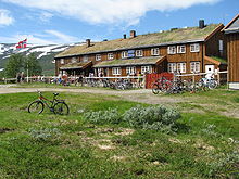
is a municipality in Trøndelag county, Norway. It is part of the Dovre region. The administrative centre of the municipality is the village of Oppdal. Other villages in the municipality include Lønset, Vognillan, Fagerhaug, and Holan. The Oppdal Airport, Fagerhaug is located in the northeastern part of the municipality.
Galdhøpiggen is the highest mountain in Norway, Scandinavia, and Northern Europe. The 2,469-metre-tall (8,100 ft) mountain is located in Lom Municipality in Innlandet county, Norway. It is in the Jotunheimen mountains within Jotunheimen National Park. The mountain sits about 25 kilometres (16 mi) southwest of the village of Fossbergom and about 45 kilometres (28 mi) northeast of the village of Øvre Årdal. The mountain is surrounded by several other notable mountains including Keilhaus topp to the east; Store Styggehøe to the southeast; Svellnosbreahesten, Midtre Tverråtinden, and Store Tverråtinden to the south; Storjuvtinden and Skardstinden to the west; Veslpiggen, Storgrovtinden, and Storgrovhøe to the northwest; and Galdhøi and Juvvasshøi to the northeast.

Rocky Mountain National Park is a national park of the United States located approximately 55 mi (89 km) northwest of Denver in north-central Colorado, within the Front Range of the Rocky Mountains. The park is situated between the towns of Estes Park to the east and Grand Lake to the west. The eastern and western slopes of the Continental Divide run directly through the center of the park with the headwaters of the Colorado River located in the park's northwestern region. The main features of the park include mountains, alpine lakes and a wide variety of wildlife within various climates and environments, from wooded forests to mountain tundra.

Kebnekaise is the highest mountain in Sweden. The Kebnekaise massif, which is part of the Scandinavian mountain range, has two main peaks. The glaciated southern peak used to be the highest at 2,120 metres (6,960 ft) above sea level, but has shrunk by 24 meters during the last 50 years, making the northern icefree peak at 2,096.8 metres (6,879 ft) the highest. Kebnekaise lies in Swedish Lapland, about 150 kilometres (93 mi) north of the Arctic Circle and west of Kiruna near the Kungsleden hiking trail between Abisko and Hemavan.

Mount Timpanogos, often referred to as Timp, is the second-highest mountain in Utah's Wasatch Range. Timpanogos rises to an elevation of 11,752 ft (3,582 m) above sea level in the Uinta-Wasatch-Cache National Forest. With 5,270 ft (1,610 m) of topographic prominence, Timpanogos is the 47th-most prominent mountain in the contiguous United States.

Dovrefjell–Sunndalsfjella National Park is a National Park in Norway. It was established in 2002 to replace and enlarge the former Dovrefjell National Park which had been established in 1974. The park occupies 1,693 square kilometres (654 sq mi) and encompasses areas in three Norwegian counties: Innlandet, Trøndelag, and Møre og Romsdal and includes large parts of the mountain range of Dovrefjell along with the Sunndalsfjella mountains. Together with the National Park, there are eight landscape protected areas and two biotope protected areas that were established adjacent to the park in 2002, comprising a total protected area of 4,366 square kilometres (1,686 sq mi). The park itself lies within the municipalities of Dovre and Lesja, Oppdal municipality, and Sunndal and Molde municipalities.

Jotunheimen is a mountainous area of roughly 3,500 square kilometres (1,400 sq mi) in southern Norway and is part of the long range known as the Scandinavian Mountains. The 29 highest mountains in Norway are all located in the Jotunheimen mountains, including the 2,469-metre (8,100 ft) tall mountain Galdhøpiggen. The Jotunheimen mountains straddle the border between Innlandet and Vestland counties.

Glacier National Park is part of a system of 43 parks and park reserves across Canada, and one of seven national parks in British Columbia. Established in 1886, the park encompasses 1,349 km2 (521 sq mi), and includes a portion of the Selkirk Mountains which are part of the larger grouping of mountains, the Columbia Mountains. It also contains the Rogers Pass National Historic Site.

Innerdalstårnet or Dalatårnet is a 1,452-metre (4,764 ft) tall mountain on the south side of the Innerdalen valley in Sunndal Municipality in Møre og Romsdal county, Norway. It is located about 15 kilometres (9.3 mi) southeast of the village of Ålvundeid. The mountain is also known as the Matterhorn of Norway for its characteristic pyramidal shape.
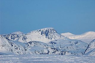
Snota is a prominent mountain in the Trollheimen mountain range in the municipality of Surnadal in Møre og Romsdal county, Norway. It is also the highest mountain in the municipality of Surnadal. It lies west of the mountain Trollhetta and north of the mountain Neådalssnota.

Gjevillvatnet is a lake in the municipality of Oppdal in Trøndelag county, Norway. It is located in the Trollheimen mountain range, about 5 kilometres (3.1 mi) south of the mountain Blåhøa and about 5 kilometres (3.1 mi) northwest of the village of Vognillan.

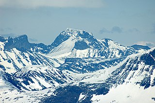
Trollhøtta or Trollhetta is a mountain on the border of Trøndelag and Møre og Romsdal counties in Norway. The 1,616-metre (5,302 ft) tall mountain is located on the border of the municipalities of Surnadal and Rindal. It is part of the Trollheimen mountain range, just east of the lake Gråsjøen and the mountains Snota and Neådalssnota. To the south, across the valley Svartådalen, you see the mountains Geithetta and Svarthetta.

Såtbakkollen is a 1,632-metre (5,354 ft) tall mountain in Sunndal Municipality in Møre og Romsdal county, Norway. It is located in the Trollheimen mountain range, just north of the Sunndalen valley. It forms the southern end of the "Tårn massif", which also includes Tåga, Tårnfjellet, and the quite famous Innerdalstårnet. Other mountains nearby include Navardalsnebba, Trolla, and Skarfjellet.
Innerdalen is a valley in Sunndal Municipality in Møre og Romsdal county, Norway. In 1967, the valley was established as Norway's first nature reserve. The valley and nature reserve begins at the village of Ålvundeidet by the Norwegian National Road 70 in the west and stretches approximately 25 kilometres (16 mi) to the east to Innerdalsporten. It lies within the Trollheimen mountain range.

Ångardsvatnet is a lake in the municipality of Oppdal in Trøndelag county, Norway. The 3.24-square-kilometre (1.25 sq mi) lake lies in the Storlidalen valley, about 13 kilometres (8.1 mi) northwest of the village of Lønset and about 35 kilometres (22 mi) west of the village of Oppdal. The lake is about 4.8 kilometres (3.0 mi) long and about 950 metres (3,120 ft) wide. It is surrounded by the Trollheimen mountain range including the mountains Gråfjellet, Kråkvasstind, and Lorthøa to the south and Bårdsgardskammen and Okla to the north. The lake Gjevillvatnet lies in the next valley to the north of Ångardsvatnet.

Kotla is the name of a valley in Northern Bagh the name of the main village of this valley is Kotla,on the basis of which the entire valley was named Kotla Valley. Kotla is a Village and tourist resort in Bagh District, Azad Kashmir, Pakistan. Kotla is 6,560 feet (2,000 m) above sea level. Kotla contains pine trees that are hundreds of years old. It takes approximately 1 hour to drive from Bagh to Kotla.

Kabardino-Balkarski Nature Reserve is a Russian 'zapovednik' on main ridge of the north Caucasus Mountains. It contains all of the mountains in Europe over 5,000 meters besides Mt. Elbrus and Mt. Kazbek, and contains the most glaciers. The ridge at the reserve forms the famous "Bezengi wall" consisting of the peaks Gestola, Katyn-Tau, Janga, Eastern Jangi-Tau and Shkhara. There are 256 glaciers in the reserve's boundaries. The reserve is situated in the Chereksky District of Kabardino-Balkar Republic; it was created in 1976, and covers an area of 82,507 ha (318.56 sq mi).