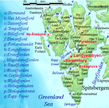
Svalbard, also known as Spitsbergen or Spitzbergen, is a Norwegian archipelago in the Arctic Ocean. North of mainland Europe, it lies about midway between the northern coast of Norway and the North Pole. The islands of the group range from 74° to 81° north latitude, and from 10° to 35° east longitude. The largest island is Spitsbergen, followed in size by Nordaustlandet and Edgeøya. The largest settlement is Longyearbyen on the west coast of Spitsbergen.
Svalbard is an archipelago in the Arctic Ocean roughly centered on 78° north latitude and 20° east longitude. The archipelago is the northernmost part of the Kingdom of Norway. The three main islands in the group consist of Spitsbergen, Nordaustlandet and Edgeøya. There are also a number of smaller islands, such as Barents Island (Barentsøya), Kvitøya, Prins Karls Forland, Kongsøya, Bear Island, Svenskøya, Wilhelm Island and other smaller islands or skerries.

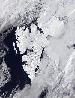
Spitsbergen is the largest and the only permanently populated island of the Svalbard archipelago in northern Norway.
The polar archipelago of Svalbard was first discovered by Willem Barentsz in 1596, although there is disputed evidence of use by Pomors or Norsemen. Whaling for bowhead whales started in 1611, dominated by English and Dutch companies, though other countries participated. At that time there was no agreement about sovereignty. Whaling stations, the largest being Smeerenburg, were built during the 17th century, but gradually whaling decreased. Hunting was carried out from the 17th century by Pomors, but from the 19th century it became more dominated by Norwegians.

Edgeøya, anglicised as Edge Island, is a Norwegian island located in southeast of the Svalbard archipelago; with an area of 5,073 square kilometres (1,960 sq mi), it is the third-largest island in this archipelago. An Arctic island, it forms part of the Søraust-Svalbard Nature Reserve, home to polar bears and reindeer. An ice field covers its eastern side. The island takes its name from Thomas Edge, an English merchant and whaler. It is seldom visited today and development of tourist facilities is forbidden by law because of its nature reserve status.

Danes Island is an island in Norway's Svalbard archipelago in the Arctic Ocean with an area of 40.6 km2 (15.7 sq mi). It lies just off the northwest coast of Spitsbergen, the largest island in the archipelago, near to Magdalenefjorden. Just to the north lies Amsterdam Island. Most of Svalbard's islands, including Danes Island, are uninhabited; only Spitsbergen, Bjørnøya and Hopen have settlements.
Wijdefjord is the longest fjord in Norway's Svalbard archipelago. Wijdefjord is located in the northern portion of the island of Spitsbergen, which lies in the Arctic Ocean about midway between Norway and the North Pole, and is the largest island in the archipelago. The fjord is 108 km (67 mi) long. Opening on Spitsbergen's north coast, it runs roughly southwards into the interior, separating Andrée Land in the west from Margaretas Land in the east. The southern half of the fjord is part of Indre Wijdefjorden National Park.

Nordre Isfjorden National Park lies on Spitsbergen Island in the Svalbard archipelago, Norway. It lies across the Isfjorden north of Barentsburg. The park was opened in 2003.
Jonas Poole was an early 17th-century English explorer and sealer, and was significant in the history of whaling.
Bellsund is a 20-kilometer (12 mi) long sound on the west coast of Spitsbergen, part of the Svalbard archipelago of Norway. It is separated from Van Mijenfjorden by the islands of Akseløya and Mariaholmen. Bellsund is located south of Nordenskiöld Land and north of Wedel Jarlsberg Land.
Magdalenefjorden is an 8 km long and up to 5 km wide fjord between Reuschhalvøya and Hoelhalvøya, Albert I Land, on the west coast of Spitsbergen, the largest island in the Svalbard archipelago. It is large enough to accommodate even the largest of cruise ships which are even able to turn through 180 degrees in the fjord. On the south shore of the fjord is the bay Gullybukta.

Krossfjorden is a 30 km long fjord on the west coast of Spitsbergen, which is the largest and only permanently populated island of the Svalbard archipelago in Norway. To the north, the fjord branches into Lillehöökfjorden, Möllerfjorden and Kollerfjorden. To the south it is separated from Kongsfjorden by a line from Collinsodden on Mitrahalvøya east to Kapp Guissez.
Billefjorden is the central fjord of the three branching from the innermost part of the Isfjorden to the northeast, in Svalbard, Norway. It is 30 km long and 5–8 km wide. Billefjorden lies between Dickson Land to the northwest and Bünsow Land in the southeast. Located on its northwestern shore is the former Russian coal mining community of Pyramiden. To the northeast is Nordenskiöldbreen. At its northeastern extreme is Adolf Bay.
Adventfjorden is a 7 km long and 4 km wide bay running south-eastwards from the southern side of Isfjorden, on the west coast of Spitsbergen in Svalbard. The name represents a corruption of Adventure Bay - probably named after the Hull-built whaleship Adventure, which operated in Isfjorden in 1656. The fjord was originally known as Klass Billen Bay. At the head of Adventfjorden is Adventdalen.
Grønfjorden is a 16 km long fjord, separated from Isfjorden to the north by Festningsodden in the west and Heerodden in the east. It lies within the western portion of Nordenskiöld Land. On its eastern shore is the mining community of Barentsburg, the second largest settlement on Spitsbergen.
Kobbefjorden is a small fjord on the west coast of Danes Island, on the northwestern coast of Spitsbergen, the largest island of the Svalbard archipelago. The fjord is about two miles (3.5 km) long and 1-1.2 miles (1.5–2 km) wide. It offers one of the best anchorages on Spitsbergen's northwest coast, "being sheltered from most winds and ice-free for much of the year." At the head of the fjord is a valley, Kobbefjorddalen, which leads to the east coast of Danes Island. Kobbefjorden's southwesternmost point is Luftskipodden. Sir Martin Conway, on his visit to Spitsbergen in 1896–97, described the fjord as having "ice-smoothed hills of [the] hardest rock."

Adventdalen is a 30-kilometre (19 mi) valley on the island Spitsbergen in Svalbard, Norway. The river that runs through the valley, Adventdalselva, flows into Adventfjorden just outside Longyearbyen. Adventfjorden is an arm of Isfjorden.

Indre Wijdefjorden National Park is located in a steep fjord landscape in northern Spitsbergen in Svalbard, Norway. It covers the inner part of Wijdefjorden—the longest fjord on Svalbard. The national park was established on 9 September 2005 and covers 1,127 km2 (435 sq mi), of which 745 km2 (288 sq mi) is on land and 382 km2 (147 sq mi) is sea. The marine environment changes vastly from the mouth of the fjord, through a still, cold, water basin, becoming deeper before reaching the glacier Mittag-Lefflerbreen at the inner-most sections of the fjord.
Sefströmbreen is a glacier in James I Land at Spitsbergen, Svalbard. It is debouching into Ekmanfjorden at the northern side of Isfjorden. The glacier is named after Nils Gabriel Sefström. During a surge in 1896 the glacier deposited large moraine ridges in the inner part of the fjord, and these can be seen at the islands of Coraholmen and Flintholmen. Sefströmbreen is included in the Nordre Isfjorden National Park.

Daudmannsøyra Important Bird Area is a 1000 ha tract of land at Daudmannsøyra, a coastal plain on the western side of Spitsbergen, the largest island of Norway’s arctic Svalbard archipelago. It lies in south-western Oscar II Land on the northern side of the entrance to the inlet of Isfjorden. It is flat with boggy terrain studded with freshwater ponds. It was identified as an Important Bird Area (IBA) by BirdLife International because it supports populations of pink-footed and barnacle geese.