
Svalbard, previously known as Spitsbergen or Spitzbergen, is a Norwegian archipelago in the Arctic Ocean. North of mainland Europe, it lies about midway between the northern coast of Norway and the North Pole. The islands of the group range from 74° to 81° north latitude, and from 10° to 35° east longitude. The largest island is Spitsbergen, followed in size by Nordaustlandet and Edgeøya. The largest settlement is Longyearbyen on the west coast of Spitsbergen.

Spitsbergen is the largest and the only permanently populated island of the Svalbard archipelago in northern Norway.

Bear Island is the southernmost island of the Norwegian Svalbard archipelago. The island is located at the limits of the Norwegian and Barents Seas, approximately halfway between Spitsbergen and the North Cape. Bear Island was discovered by Dutch explorers Willem Barentsz and Jacob van Heemskerck on 10 June 1596. It was named after a polar bear that was seen swimming nearby. The island was considered terra nullius until the Spitsbergen Treaty of 1920 placed it under Norwegian sovereignty.

The Scullin Monolith is a crescent-shaped rock fronting the sea 6 km (3.7 mi) west of the similar Murray Monolith, and 8 km (5.0 mi) from Torlyn Mountain, in Mac. Robertson Land, Antarctica. It is a steep massif of metasedimentary gneiss and granitic origin, with the adjacent coastline consisting of 40 m high ice cliffs. The monolith rises steeply to extend from 435 m high Mikkelsen Peak westward in a crescent that forms Douglas Bay.
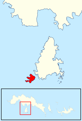
Nordvest-Spitsbergen National Park is located on the Norwegian arctic archipelago of Svalbard and includes parts of north-west Spitsbergen and nearby islands such as Danes Island and Moffen. It contains, among other things, warm springs and remains of volcanoes in Bockfjorden.

Isfjorden is the second longest fjord in the Norwegian archipelago of Svalbard. It lies on the west side of Spitsbergen, an island in the Arctic Ocean about midway between Norway and the North Pole, and the largest in the archipelago. The mountain of Alkhornet stands on the northern side of the entrance to the fjord, as does the coastal plain of Daudmannsøyra. A portion of Isfjorden is included in the national parks of Norway as Nordre Isfjorden Land National Park. Around the fjord lie many of the largest settlements in Svalbard: Barentsburg, Longyearbyen and Pyramiden.

Varangerhalvøya National Park lies on the Varanger Peninsula in Troms og Finnmark county, Norway. It is located in the municipalities of Båtsfjord, Nesseby, Vadsø, and Vardø, in the northeasternmost part of Norway. The peninsula was earlier the largest area within the Arctic climate zone in mainland Norway, but with the 1991-2020 normals, much of the area is boreal rather than arctic. Much of the area is still alpine tundra.

Nordaust-Svalbard Nature Reserve is located in the north-eastern part of the Svalbard archipelago in Norway. The nature reserve covers all of Nordaustlandet, Kong Karls Land, Kvitøya, Sjuøyane, Storøya, Lågøya, Wilhelm Island, Wahlbergøya and a small section of the north-east corner of Spitsbergen. The reserve is 55,354 square kilometres (21,372 sq mi), of which 18,663 square kilometres (7,206 sq mi) is on land and 36,691 square kilometres (14,166 sq mi) is on water—making it the largest preserved area in Norway. It includes the largest glacier in Norway, Austfonna, as well as Vestfonna and parts of Olav V Land. The reserve has been protected since 1 July 1973 and borders in the south to Søraust-Svalbard Nature Reserve.

Søraust-Svalbard Nature Reserve is located in the south-eastern part of the Svalbard archipelago in Norway. The nature reserve covers all of Edgeøya and Barentsøya in addition to a number of smaller islands, including Thousand Islands, Ryke Yseøyane and Halvmåneøya. The reserve is 21,825 square kilometres (8,427 sq mi), of which 6,400 square kilometres (2,500 sq mi) is on land and 15,426 square kilometres (5,956 sq mi) is on water—making it the second-largest preserved area in Norway. The reserve has been protected since 1 July 1973 and borders the Nordaust-Svalbard Nature Reserve to the north.
Svalbard is an Arctic, wilderness archipelago comprising the northernmost part of Norway. It is mostly uninhabited, with only about 3,000 people, yet covers an area of 61,020 square kilometres (23,560 sq mi).

Grey Island is 1 km (0.62 mi) south of Michelsen Island and 2 km (1.2 mi) west of the southern part of Fredriksen Island, in the South Orkney Islands of Antarctica. It was first charted and named Holmen Graa on a map by the Norwegian whaler Captain Petter Sorlle, who made a running survey of the South Orkney Islands in 1912–13. The anglicised form appears on the chart by Discovery Investigations personnel on the Discovery II who surveyed the islands in 1933.
Moe Island is an island 2 km (1.2 mi) long in the South Orkney Islands off Antarctica, separated from the south-west end of Signy Island by Fyr Channel. It was charted by Captain Petter Sørlle in 1912–13, and named after M. Thoralf Moe of Sandefjord, Norway, a contemporary whaling captain who worked in this area. The northernmost point of the island is Spaull Point, named by United Kingdom Antarctic Place-Names Committee (UK-APC) after Vaughan W. Spaull, British Antarctic Survey (BAS) biologist on Signy Island, 1969.
Nordenskiöld Land is the land area between Isfjorden and Van Mijenfjorden on Spitsbergen, Svalbard. The area is named after Finnish-Swedish explorer and geologist Nils Adolf Erik Nordenskiöld. The coastal region of Nordenskiöld Land (Nordenskiøldkysten) has been identified as an Important Bird Area (IBA) by BirdLife International because it supports breeding populations of barnacle geese and common eiders.

Kongsfjorden Bird Sanctuary is a 140 ha bird reserve at Svalbard, Norway, established in 1973. It includes islands and islets in Kongsfjorden, Haakon VII Land. It lies at the inner end of the fjord and consists of about ten islands, mainly covered with grassy vegetation and having small freshwater ponds. The fjord is surrounded by steep mountains, cliffs, glaciers and tundra. The reserve has been recognised as a wetland of international importance by designation under the Ramsar Convention. It has also been identified as an Important Bird Area (IBA) by BirdLife International. It supports breeding populations of pink-footed and barnacle geese, common and king eiders, long-tailed ducks, purple sandpipers, red phalaropes, glaucous gulls, long-tailed jaegers and snow buntings. Ivory gulls have been recorded.

Trygghamna is a bay in Oscar II Land at Spitsbergen, Svalbard. It is about six kilometer long, located at the northern side of Isfjorden, east of Protektorfjellet, and separated from Ymerbukta by the mountain chain Värmlandryggen.

Ingeborgfjellet is a mountain in Nordenskiöld Land in Spitsbergen, Svalbard. It has a height of 715 m with a secondary peak of 620 m. It is included in the Nordenskiöld Land National Park, and has an important bird cliff. Ingeborgfjellet is located north of Bellsund and west of the glacier Fridtjovbreen. It forms a characteristic ridge and is an easily recognized landmark viewed from sea.

Daudmannsøyra Important Bird Area is a 1000 ha tract of land at Daudmannsøyra, a coastal plain on the western side of Spitsbergen, the largest island of Norway’s arctic Svalbard archipelago. It lies in south-western Oscar II Land on the northern side of the entrance to the inlet of Isfjorden. It is flat with boggy terrain studded with freshwater ponds. It was identified as an Important Bird Area (IBA) by BirdLife International because it supports populations of pink-footed and barnacle geese.
The Fuglefjella Important Bird Area is a 500 ha tract of sea-cliffs in Spitsbergen, the largest island of Norway’s arctic Svalbard archipelago. The cliffs rise from sea level to an elevation of 470 m on the southern side of the inlet of Isfjorden, some 10 km west of the territory's principal human settlement of Longyearbyen. It was identified as an Important Bird Area (IBA) by BirdLife International because it supports about 20,000 breeding pairs of several species of seabirds.

The wildlife of Norway includes the diverse flora and fauna of Norway. The habitats include high mountains, tundras, rivers, lakes, wetlands, sea coast and some lower cultivated land in the south. Mainland Norway has a long coastline, protected by skerries and much dissected by fjords, and the mostly-icebound archipelago of Svalbard lies further north. The flora is very varied and a large range of mammals, birds, fish and invertebrate species live here, as well as a few species of reptiles and amphibians.
