Related Research Articles

Wahlenbergfjorden, sometimes known in English as Waalenburg Bay, is a fjord on the southwest coast of the Arctic island of Nordaustlandet, in Norway's Svalbard archipelago. At 46 kilometres (29 mi) in length, and 15 km (9.3 mi) wide, it is the fifth longest fjord in the archipelago, and the longest on the island. The fjord separates Gustav V Land in the north from Gustav Adolf Land in the south, at geographical co-ordinates 79°40′N20°00′E. Its mouth faces Spitsbergen across Hinlopen Strait, the strait separating the two islands.

Kongsfjorden is an inlet on the west coast of Spitsbergen, an island which is part of the Svalbard archipelago in the Arctic Ocean. The inlet is 26 km (16 mi) long and ranges in width from 6 to 14 km. Two glaciers, Kronebreen and Kongsvegen, head the fjord.

Billefjorden is the central fjord of the three branching from the innermost part of the Isfjorden to the northeast, in Svalbard, Norway. It is 30 km long and 5–8 km wide. Billefjorden lies between Dickson Land to the northwest and Bünsow Land in the southeast. Located on its northwestern shore is the former Russian coal mining community of Pyramiden. To the northeast is Nordenskiöldbreen. At its northeastern extreme is Adolf Bay.
Indre Wijdefjorden National Park is located in a steep fjord landscape in northern Spitsbergen in Svalbard, Norway. It covers the inner part of Wijdefjorden—the longest fjord on Svalbard. The national park was established on 9 September 2005 and covers 1,127 km2 (435 sq mi), of which 745 km2 (288 sq mi) is on land and 382 km2 (147 sq mi) is sea. The marine environment changes vastly from the mouth of the fjord, through a still, cold, water basin, becoming deeper before reaching the glacier Mittag-Lefflerbreen at the inner-most sections of the fjord.

Austfjorden is a fjord in Spitsbergen, Svalbard in Arctic Norway. The fjord, measuring 32 kilometres is located in the east of the Indre Wijdefjorden National Park.
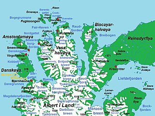
Liefdefjorden is a fjord in Haakon VII Land on Spitsbergen, Svalbard. It has a length of about 30 km (19 mi). Former names of the fjord include Baye d'Amour, Kjærlighedsbugten, Porto detto l'Amato, Liefde Bay and Love Bay. Monacobreen debouches into the fjord. At the northern side of the outer part of the fjord is the peninsula Reinsdyrflya. Liefde is Dutch for "love" and the fjord is possible named after a ship "de Liefde".
Vestfjorden is the inner, western branch of Wijdefjorden, between Andrée Land and the northern part of Dickson Land in Spitsbergen, Svalbard in Arctic Norway. It is 12 km long and 5 km wide at the inlet between Kapp Petermann, Ræstadholmen and Krosspynten. Continues on land as Vestfjorddalen to the south and later southwest. Silty rivers comes from Landingsdalen, Yggbreen and Angelbreen on the west, as well as Vestfjorddalen in the south, giving the fjord a reddish look in contrast to the green colour of Wijdefjorden.
Möllerfjorden is the 9 kilometer long Eastern fjord branch of Krossfjorden located at the northwestern side of Spitsbergen, Svalbard. The fjord is named after astronomer Didrik Magnus Axel Möller. Möllerfjorden is separated from Lilliehöökfjorden by the peninsula and mountain ridge Kong Haakons Halvøy.

Lilliehöökfjorden is a 14 kilometer long fjord branch of Krossfjorden in Albert I Land at the northwestern side of Spitsbergen, Svalbard. The fjord is named after Gustaf Bertil Lilliehöök.
St. Jonsfjorden is a fjord in Oscar II Land at Spitsbergen, Svalbard. It has a length of 21 kilometer, and opens westwards into the strait of Forlandsundet. Several glaciers debouche into the fjord, including Gaffelbreen and Konowbreen from the north, a merge of Osbornebreen, Devikbreen, Vintervegen, Paulbreen and Bukkebreen at the bottom, and Vegardbreen, Charlesbreen and Bullbreen from the south.
Klinckowströmfjorden is the eastern branch of Raudfjorden at Spitsbergen, Svalbard, on the divide between Albert I Land and Haakon VII Land. It is named after Swedish zoologist Axel Klinckowström. The glacier Raudfjordbreen debouches into the fjord. The peninsula Buchananhalvøya separates Klinckowströmfjorden from the western fjord branch Ayerfjorden. The mountain Ben Nevis is located southeast of the fjord.

Sorgfjorden is a fjord at the northeastern coast of Spitsbergen, Svalbard. It cuts into Ny-Friesland, from the northern part of Hinlopen Strait. It is also called Treurenberg Bay.
Palanderbukta is a fjord or bay in Gustav Adolf Land at Nordaustlandet, Svalbard, a southern bay of Wahlenbergfjorden. The bay is named after Swedish naval officer Louis Palander.
Buchananhalvøya is a peninsula in Albert I Land at Spitsbergen, Svalbard. It is located at the head of Raudfjorden, where the fjord branches into Ayerfjorden to the west and Klinckowströmfjorden to the east of the peninsula. It is named after John Young Buchanan. The mountain Buchanantoppen is located at the southern part of the peninsula, with Chauveaubreen to the west and Raudfjordbreen at the eastern side.
Sefströmbreen is a glacier in James I Land at Spitsbergen, Svalbard. It is debouching into Ekmanfjorden at the northern side of Isfjorden. The glacier is named after Nils Gabriel Sefström. During a surge in 1896 the glacier deposited large moraine ridges in the inner part of the fjord, and these can be seen at the islands of Coraholmen and Flintholmen. Sefströmbreen is included in the Nordre Isfjorden National Park.
Fuglefjorden is a fjord in Albert I Land at Spitsbergen, Svalbard. It is located on the northern side of the peninsula Vasahalvøya, and has a length of three nautical miles. The island of Fugløya divides the fjord into two branches. The eastern branch has several islets, skerries and shoals.
Fugløya is an island in Albert I Land at Spitsbergen, Svalbard. It has a size of about 2.5 square kilometers, and is located off the peninsula Vasahalvøya, in the mouth of Fuglefjorden, and divides the fjord into two branches.
Vasahalvøya is a peninsula in Albert I Land at Spitsbergen, Svalbard. The peninsula is named after Gustav Vasa. It is located between the fjords of Smeerenburgfjorden and Raudfjorden. The peninsula is filled with ruggy and pointed mountains and glacier filled valleys. The highest peak is Stortinden.
Bjørnfjorden is a fjord in Albert I Land at Spitsbergen, Svalbard. The fjord is located between Reuschhalvøya and Vasahalvøya, and is an inner branch of Smeerenburgfjorden. Smeerenburgbreen debouches into the fjord. At the south side of the fjord are Scheibukta and St. Laurentiusbukta.
Oxfordhalvøya is a peninsula in Wahlenbergfjorden at the southwestern side of Nordaustlandet, Svalbard. It is located between Bodleybukta and Etonbreen at the head of the fjord. The bay Kløverbladbukta cuts into the peninsula, and its highest point is Carfaxhaugen at 103 m.a.s.l. The river of Oxfordelva flows from the lake of Brånevatnet through Oxfordhalvøya, and debouches into Bodleybukta.
References
- ↑ "Bockfjorden (Svalbard)". Norwegian Polar Institute . Retrieved 29 June 2013.
- ↑ Arctic Pilot: Sailing directions Svalbard–Jan Mayen. Vol. 7. Stavanger: The Norwegian Hydrographic Service and The Norwegian Polar Institute. 1988. p. 291. ISBN 82-90653-06-9.
79°28′08″N13°19′43″E / 79.4690°N 13.3287°E
| | This article about a fjord in Spitsbergen is a stub. You can help Wikipedia by expanding it. |