External links
- Setesdal Vesthei - Ryfylkeheiane The board of Norwegian national parks (in Norwegian)
59°10′26″N7°20′32″E / 59.1738°N 7.3423°E
| | This Norway-related article is a stub. You can help Wikipedia by expanding it. |
| Setesdal Vesthei- Ryfylkeheiane | |
|---|---|
IUCN category IV (habitat/species management area) | |
| Location | Aust-Agder, Vest-Agder, Rogaland, Norway |
| Nearest city | Kristiansand, Stavanger, |
| Area | 2 448 km² |
| Established | 2000 |
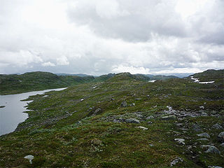
Setesdal Vesthei Ryfylkeheiane is a protected area in Norway.
59°10′26″N7°20′32″E / 59.1738°N 7.3423°E
| | This Norway-related article is a stub. You can help Wikipedia by expanding it. |

Bygland is a municipality in Agder county, Norway. It is located in the traditional district of Setesdal. The administrative centre of the municipality is the village of Bygland. Other villages in the municipality include Åraksbø, Austad, Byglandsfjord, Grendi, Langeid, Lauvdal, Litveit, Longerak, Moi, Ose, Sandnes, Skåmedal, and Tveit. The Norwegian National Road 9 runs through the municipality, following the river Otra where most of the population of Bygland lives.

Valle is a municipality in Agder county, Norway. It is located in the traditional district of Setesdal. The administrative centre of the municipality is the village of Valle. Other villages in Valle include Besteland, Brokke, Homme, Hovet, Rygnestad, Rysstad, and Uppstad.
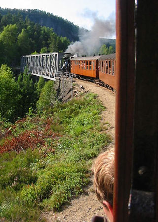
The Setesdal Line was a railway between Kristiansand and Byglandsfjord in southern Norway, 78 km (48 mi) long. It was built with a narrow gauge of 1,067 mm, and opened to Hægeland 26 November 1895, and to Byglandsfjord 27 November 1896. Stations along the line included Mosby, Vennesla, Grovene (Grovane), Iveland and Hægeland.
Jarlsberg was a former countship that forms a part of today's Vestfold county in Norway.

Bunad is a Norwegian umbrella term. In a broader sense, the term encompasses household, householding equipment, and livestock as well as both traditional rural clothes and modern 20th-century folk costumes. In its narrowest sense, the word bunad refers only to clothes designed in the early 20th century that are loosely based on traditional costumes.
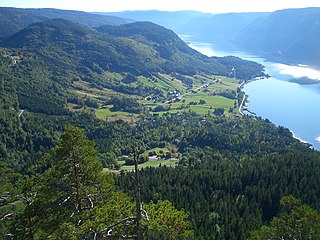
Setesdal is a valley and a traditional district in Agder County in southern Norway. It consists of the municipalities of Bykle, Valle, Bygland, Iveland, and Evje og Hornnes.

Southern Norway is the geographical region (landsdel) along the Skagerrak coast of southern Norway. The region is an informal description since it does not have any governmental function. It roughly corresponds to the old petty kingdom of Agder as well as the two former counties of Vest-Agder and Aust-Agder. From New Year 2020, the two counties have been merged into one county, Agder. The total combined area of Vest-Agder and Aust-Agder counties is 16,493 square kilometres (6,368 sq mi). The name is relatively new, having first been used in Norway around 1900.
Evjemoen was a Norwegian military camp in use from 1912 to 2002. The camp lies south of the village of Evje in Evje og Hornnes municipality in Agder county. From 1953 to 1995, Evjemoen was used as a training area for the Infanteriets øvingsavdeling II (IØ2). The camp was retired in December 2002.
The Bispevegen passes between Valle in Setesdal on the western side of the mountains and Fyresdal on the eastern side. The Bispevegen is a medieval east-west track over the high plateau that priests and bishops used to get between the counties of Agder and Telemark. Every year a march called "Bispevegmarsjen" starts at Kleivgrend in Fyresdal.
The Battle of Vinjesvingen was a battle of the Norwegian campaign and took place in May 1940 in the Telemark county, Norway. It became one of the two last strongholds of Norwegian resistance in southern Norway during World War II, the other being Hegra Fortress.
Kilefjorden is a lake on in Agder county, Norway. The lake is located on the border of the municipalities of Evje og Hornnes, Iveland, and Vennesla. The lake is part of the river Otra. The lake is located about 6 kilometres (3.7 mi) west of the village of Birketveit in Iveland, about 2.5 kilometres (1.6 mi) north of the village of Hægeland in Vennesla, and about 15 kilometres (9.3 mi) south of the village of Hornnes in Evje og Hornnes.

Kirsten Marie Bråten Berg is a Norwegian traditional folk singer, silversmith and government scholar. She is currently living in Valle in the Setesdal area of southern Norway. She trained as a silversmith at the Torleiv H. Bjørgums Vocational College in Setesdal and then set up her own workshop there, in Nomeland.

Evje is a former municipality in the old Aust-Agder county in Norway. The 177-square-kilometre (68 sq mi) municipality existed from 1877 until 1960. It was located in what is now the eastern part of the present-day municipality of Evje og Hornnes in the Setesdal valley of Agder county. The administrative centre was the village of Evje where the Evje Church is located. The lake Høvringsvatnet is located about 10 kilometres (6.2 mi) northeast of the village.
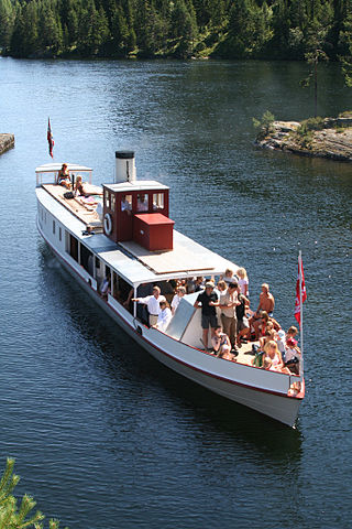
SS Bjoren is a wood-fuelled steamboat that travels the route between Bygland-Byglandsfjord, Bygland and Bygland-Ose on the lake Byglandsfjorden in the municipality of Bygland in the Setesdal valley. She runs on Sundays in July.
Setesdalsheiene is the collective term for the mountains to the west and east of the Setesdalen valley in Agder county in Southern Norway. The river Otra flows through the valley between the mountains. This area is primarily located in the municipalities of Bykle, Valle, Bygland, Evje og Hornnes, Sirdal, Kvinesdal, and Åseral. The vast Hardangervidda plateau lies to the north and the Ryfylkeheiene mountains lie to the west.
Stev is a form of Norwegian folk song consisting of four line lyric stanzas. The English version of the word is stave, meaning the stressed syllable in a metric verse.

Norwegian County Road 419 (Fv419) is a Norwegian county road which runs between the villages of Hannåsmoen and Klepp in Evje og Hornnes municipality in Agder county, Norway. The 1.8-kilometre (1.1 mi) long road includes a bridge over the river Otra. It is one of five bridges over the river Otra in the municipality. The western end of the road connects with the Norwegian National Road 9 which runs north–south into the Setesdalen valley.

Johannes Skar was a Norwegian educator and folklorist.

Norwegian National Road 9 is often called the Setesdal Road and it is the main thoroughfare through the Setesdalen valley. It runs from the city of Kristiansand in the southern coast of Norway, through the Torridal and Setesdal valleys in Agder county to Haukeligrend in Vestfold og Telemark county in the north where it meets the European route E134 highway. The highway goes through the villages of Mosby, Homstean, Skarpengland, Hægeland, Hornesund, Hornnes, Evje, Byglandsfjord, Bygland, Ose, Rysstad, Valle, Flatland, Rygnestad, Bykle, Hovden, Bjåen, and Haukeli.