
Svalbard is an archipelago in the Arctic Ocean roughly centered on
78° north latitude and 20° east longitude. The archipelago is the northernmost part of the Kingdom of Norway. The three main islands in the group consist of Spitsbergen, Nordaustlandet and Edgeøya. There are also a number of smaller islands, such as Barents Island (Barentsøya), Kvitøya, Prins Karls Forland, Kongsøya, Bear Island, Svenskøya, Wilhelm Island and other smaller islands or skerries.
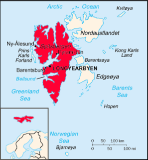
Spitsbergen is the largest and only permanently populated island of the Svalbard archipelago in northern Norway. Constituting the westernmost bulk of the archipelago, it borders the Arctic Ocean, the Norwegian Sea, and the Greenland Sea. Spitsbergen covers an area of 37,673 km2 (14,546 sq mi), making it the largest island in Norway and the 36th-largest in the world. The administrative centre is Longyearbyen. Other settlements, in addition to research outposts, are the Russian mining community of Barentsburg, the research community of Ny-Ålesund, and the mining outpost of Sveagruva. Spitsbergen was covered in 21,977 km2 (8,485 sq mi) of ice in 1999, which was approximately 58.5% of the island's total area.

Danes Island is an island in Norway's Svalbard archipelago in the Arctic Ocean. It lies just off the northwest coast of Spitsbergen, the largest island in the archipelago, near to Magdalenefjorden. Just to the north lies Amsterdam Island. Like many of Svalbard's islands, Danes Island is uninhabited. The island has an area of 40.6 km2 (15.7 sq mi).
Isfjorden is the second longest fjord in the Norwegian archipelago of Svalbard. It lies on the west side of Spitsbergen, an island in the Arctic Ocean about midway between Norway and the North Pole, and the largest in the archipelago. The mountain of Alkhornet stands on the northern side of the entrance to the fjord, as does the coastal plain of Daudmannsøyra. A portion of Isfjorden is included in the national parks of Norway as Nordre Isfjorden Land National Park. Around the fjord lie many of the largest settlements in Svalbard: Barentsburg, Longyearbyen and Pyramiden.
Van Mijenfjorden is the third-longest fjord in Norway's Svalbard archipelago. It lies in the southern portion of Spitsbergen island, south of Nordenskiöld Land and north of Nathorst Land. The fjord is 83 km (52 mi) long, being separated from Bellsund further out by Akseløya and Mariaholmen. The settlement of Sveagruva lies on the fjord's north bank.

Wahlenbergfjorden, sometimes known in English as Waalenburg Bay, is a fjord on the southwest coast of the Arctic island of Nordaustlandet, in Norway's Svalbard archipelago. At 46 kilometres (29 mi) in length, and 15 km (9.3 mi) wide, it is the fifth longest fjord in the archipelago, and the longest on the island. The fjord lies between Gustav V Land and Gustav Adolf Land, at geographical co-ordinates 79°40′N 20°00′E. Its mouth faces Spitsbergen across Hinlopen Strait, the strait separating the two islands.

Woodfjord is a fjord on the north shore of Spitsbergen island in the Svalbard archipelago. It is the fourth longest fjord in the Svalbard archipelago with the mouth facing north adjacent to Wijdefjord, and goes 64 km (40 mi) into the island, west of Andrée Land.

Kongsfjorden is an inlet on the west coast of Spitsbergen, an island which is part of the Svalbard archipelago in the Arctic Ocean. The inlet is 26 km (16 mi) long and ranges in width from 6 to 14 km. Two glaciers, Kronebreen and Kongsvegen, head the fjord.

Nordre Isfjorden National Park lies on Spitsbergen Island in the Svalbard archipelago, Norway. It lies across the Isfjorden north of Barentsburg. The park was opened in 2003.
Bellsund is a 20-kilometer (12 mi) long sound on the west coast of Spitsbergen, part of the Svalbard archipelago of Norway. It is separated from Van Mijenfjorden by the islands of Akseløya and Mariaholmen. Bellsund is located south of Nordenskiöld Land and north of Wedel Jarlsberg Land.
Magdalenefjorden is an 8 km long and up to 5 km wide fjord between Reuschhalvøya and Hoelhalvøya, Albert I Land, on the west coast of Spitsbergen, the largest island in the Svalbard archipelago. It is large enough to accommodate even the largest of cruise ships which are even able to turn through 180 degrees in the fjord. On the south shore of the fjord is the bay Gullybukta.

Krossfjorden is a 30 km long fjord on the west coast of Spitsbergen, which is the largest and only permanently populated island of the Svalbard archipelago in Norway. To the north, the fjord branches into Lillehöökfjorden, Möllerfjorden and Kollerfjorden. To the south it is separated from Kongsfjorden by a line from Collinsodden on Mitrahalvøya east to Kapp Guissez.
Moffen is a small, low island north of the mouth of Wijdefjorden, on the northern coast of Spitsbergen, the largest island of the Svalbard archipelago. The island lies just north of 80° so has become a popular target for vessels touring the archipelago but landing or entering the inner waters is strictly forbidden for fear of disturbing the wildlife as the island is an important haul-out area for Walrus and a nesting site for birds. The island was first labelled on a map by Hendrick Doncker, of Amsterdam, in 1655.
Kobbefjorden is a small fjord on the west coast of Danes Island, on the northwestern coast of Spitsbergen, the largest island of the Svalbard archipelago. The fjord is about two miles (3.5 km) long and 1-1.2 miles (1.5–2 km) wide. It offers one of the best anchorages on Spitsbergen's northwest coast, "being sheltered from most winds and ice-free for much of the year." At the head of the fjord is a valley, Kobbefjorddalen, which leads to the east coast of Danes Island. Kobbefjorden's southwesternmost point is Luftskipodden. Sir Martin Conway, on his visit to Spitsbergen in 1896-97, described the fjord as having "ice-smoothed hills of [the] hardest rock."
Svalbard is an Arctic, wilderness series of islands comprising the northernmost part of the Norwegian territories. It is mostly uninhabited, with only about 3,000 people, yet covers an area of 61,020 square kilometres (23,560 sq mi).

Vestfjorden is the inner, western branch of Wijdefjorden, between Andrée Land and the northern part of Dickson Land in Spitsbergen, Svalbard in Arctic Norway. It is 12 km long and 5 km wide at the inlet between Kapp Petermann, Ræstadholmen and Krosspynten. Continues on land as Vestfjorddalen to the south and later southwest. Silty rivers comes from Landingsdalen, Yggbreen and Angelbreen on the west, as well as Vestfjorddalen in the south, giving the fjord a reddish look in contrast to the green colour of Wijdefjorden.
Fuglefjorden is a fjord in Albert I Land at Spitsbergen, Svalbard. It is located on the northern side of the peninsula Vasahalvøya, and has a length of three nautical miles. The island of Fugløya divides the fjord into two branches. The eastern branch has several islets, skerries and shoals.
Bjørnfjorden is a fjord in Albert I Land at Spitsbergen, Svalbard. The fjord is located between Reuschhalvøya and Vasahalvøya, and is an inner branch of Smeerenburgfjorden. Smeerenburgbreen debouches into the fjord. At the south side of the fjord are Scheibukta and St. Laurentiusbukta.
Smeerenburgfjorden is a fjord in Albert I Land at Spitsbergen, Svalbard. It has a length of about twenty kilometers and a width of about four kilometers. The fjord is named after the old whaling settlement Smeerenburg, which was situated at the southern part of Amsterdam Island. The fjord is located between the peninsulas of Vasahalvøya and Reuschhalvøya, and connects westwards through the straits of Danskegattet and Sørgattet. The Smeerenburgbreen glacier debouches into the head of the fjord.


