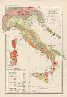
The geology of Italy includes mountain ranges such as the Alps and the Apennines formed from the uplift of igneous and primarily marine sedimentary rocks all formed since the Paleozoic. [1] Some active volcanoes are located in Insular Italy.
The geology of Italy includes mountain ranges such as the Alps and the Apennines formed from the uplift of igneous and primarily marine sedimentary rocks all formed since the Paleozoic. [1] Some active volcanoes are located in Insular Italy.
The oldest rocks in Italy may include oceanic crust subducted during the Caledonian orogeny and 440 million year old Ordovician granites. Only detrital zircons in the Alps dates to the Precambrian. [2]
These granites are located offshore of Venice, found in the Agip Assunta well and deformed, transforming into orthogneiss during the Hercynian orogeny. Overall, Italian Paleozoic rocks commonly show evidence of the Hercynian orogeny in the Alps, Sardinia, the Apuan Alps of Tuscany, and the Peloritani mountains of Sicily and Calabria.
The Hercynian orogeny produced a large thrust belt, thickened the crust and led to polyphaser metamorphism yielding rocks such as gneiss, phyllite and amphibolite. Metamorphic facies range from high-pressure kyanite to low-pressure andalusite. [3]
The Western Alps at Mont Blanc and Monte Rosa, the Southern Alps at Braveno, Brixen, Cima d'Asta, Doss del Sabion and the Barbagia and Gallura granites in Sardinia are all examples of Carboniferous and Permian granite pluton and batholith intrusions. Ignimbrite eruptions had an important role at the same time in forming parts of the central Southern Alps. Sedimentary rocks from before the Permian have remained intact and unmetamorphosed (or only having experienced low-grade metamorphism) in the Paleocarnian charn of the eastern Southern Alps. The metamorphic grade increases to the west, reaching amphibolite grade in the Orobic Alps and granulite grade in the Ivrea-Verbano Zone. Most of the basement rocks in the Dolomites are phyllite or gneiss at greenschist grade. Within the Dioritic-Kinzigitic unit, biotite and sillimanite-rich gneiss outcrop in Calabria.
At the same time in the Permian and Carboniferous, the opening of the west branch of the Tethys Ocean reoriented sections of Italy atop the Adriatic Plate and created the Ligure-Piemontese ocean basin, leading to widespread deposition of carbonates, evaporites and red beds. [4] Units such as the Valgardena Sandstone emplaced during a westward marine transgression in areas later uplifted as the Alps. These sandstones were succeeded by sabkha, the lagoonal Bellerophon Formation, volcanic rocks, the Werfen Formation and Servino Formation. [5]
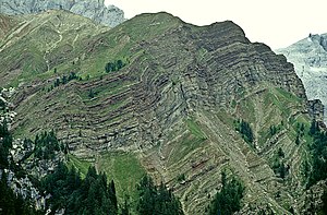
Even in the 19th century, geologists recognized Ladinian and Carnian age carbonate platforms in the Dolomites that likely formed as coral atolls. Throughout the early Triassic, the Zorzino Limestone, Rhaetian Choncodon Dolomite, Riva di Solto Shale and Zu Limestone filled the Lombard Basin. Up to two kilometers of carbonates assembled in the late Triassic as the Dolomia Principale. Meanwhile, the Lagonegro Basin accumulated limestone, chert and marl into the Jurassic. Complex tectonics produced horst and graben features and some lowlands deposited evaporites, such as the Burano Anhydrite—now a significant unit in the Apennine Mountains.
Jurassic tectonic conditions differed somewhat from the Triassic, resulting in new basin formation and a carbonate depositional environment akin to the current day Florida-Bahamas platform. Southern Alps basins such as the Lombard Basin and the Belluno Basin gathered marl and limestone, while turbidite and nodular limestone was more common in the Vajont Limestone, Fonzaso Formation and Selcifero Lombardo. In addition to wide shelf environments like the Bahamas, seamounts like the Trento Swell or the Sicilian Iblean and Saccense zones, some basins such as the Piemontese Basin, the Lagonegro Basin and the Ligurian-western Tuscan Ligure Basin were situated above ophiolite and ended up with abundant radiolarite fossils in limestone.
During the Cretaceous, global high sea levels and local tectonic conditions produced a greater share of basins than platform environments (although the Campano-Lucana, Friuli, Apulia and Latium-Abruzzi platforms persisted). More pelagic, open water sediments like marl joined breccia and underwater debris flows. Triassic conditions persisted in only one location in Sardinia where up to one kilometer of carbonates finished depositing in the Cretaceous, atop deformed Cambrian-Carboniferous metamorphic basement rock.
Changing interaction between the European Plate and the Adriatic Plate resulted in tectonic compression along the Adriatic Plate's northern margin, kicking off the formation of the Alps and the Apennines. In the late Cretaceous, foredeeps filled with flysch and molasse sediments shed off the rising mountains. Examples include the Bergamo Flysch within the Lombard Basin of the Southern Alps. [6]
The Mesozoic was largely quiescent in terms of magmatism, but some igneous activity did take place. Pietra Verde sandstones from the Ladinian in the Southern Alps contain calc-alkaline rock while granite, shoshonite and monzonite intruded the Dolomites region into the Carnian. In fact, subsurface rocks in the Po Valley, the Lagonegro Basin, west Trentino, the Venetian foothills, Sicily, Lombary and the northern Apennines show signs of volcaniclastic sediments and pillow lava from the time period.
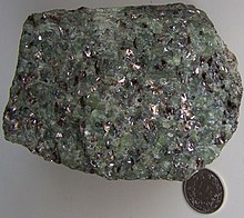
Although the oceanic crust of the Tethys Ocean has been recycled into the mantle, sections of it remain as ophiolite with peridotite, gabbro, prasinite, serpentinite and pillow lava of Jurassic to Cretaceous age in Liguria, Tuscany, Val d'Aosta and Piemonte. [7] Petrological research indicates that ophiolites in the Alps are metamorphosed, while those in the Apennines are not. The Ragusa Basin in the Iblean Plateau of Sicily had magmatism in the Jurassic, together with the Trapanese Basin, followed by Cretaceous activity in the Syracuse area. [8]
During the Paleocene, the Eurasia-Africa convergent margin driving the Alpine orogeny accompanied the closure of Alpine Tethys ocean basin. As a result, magmatism emplaced in the Periadriatic region lasting into the Oligocene: Basalt dyke intrusions (Dolomites) and volcaniclastic rocks (Lessini Mountains), alongside various batholiths (acid rocks like trachyte, tonalite, syenite,...) can be found. The Alpine tectonics affected the magmatic bodies during the uplift: the Insubric Lineament dividing the Southern Alps, for example, sheared the Bregaglia batholith.
Sedimentary processes were affected from the orogeny in form of turbiditic deposits accumulating in nearby basins. In the North-east, Eocene age flysch shed off the Dinaric Alps can be found in the present-day foothills of Friuli region, while shallow water deposition (shale and carbonates) persisted in areas further away from the thrust belt. Paleontological evidences include the fish fossils of Bolca quarry ( close to Verona).
In the Eocene, the Apennine orogeny started evolving independently from the Alps as a result of a new west-dipping subduction and continental collision between Corsica-Sardinia block and Adria microplate. Following the eastward migrating subduction zone, sediments of the Adriatic margin and Ionian Basin accreted onto the Apennine area as a tectonic nappe stacking from the west. As the Adria microplate migrated to the northeast with an anti-clockwise rotation, Apennine foredeeps migrated to the east with continued flysch deposition in younging basins from west to east (Macigno, Cervarola, Marnoso-Arenacea...). In the Northern Apennines, the Liguride units (oceanic sediments and ophiolites) were deformed and later (Oligo-Miocene) thrusted upon Tuscan and Umbria-Marche Units (passive margin pelagic basins). In Central-Southern Italy, carbonate platforms (Lazio-Abruzzi, Apulia...) persisted alongside turbiditic basins (Lagonegro...) up until late Miocene. In the Southern Apennines, like the Liguride Units, flysch units with ophiolite were incorporated in the orogenic arc (Cilento Flysch, Flysch Rosso and Frido Flysch). The deformational history of these units is recorded by the alternating shale, sandstone and conglomerate. In Sicily the Maghreb-related Numidian Flysch from Miocene contains quartz and arenite sands likely deposited by a river delta from Africa and overlain by the coarser Goroglione Flysch.
During the Miocene, the ongoing uplift affected Alps as well as the Paleo-Apenninic chain and backarc to foredeep basins continued developing. In the Southern Alps, Gonfolite Lombarda and Molassa Bellunese flysch started filling the Po basin. Around the Apennines and Sicily, late Miocene evaporites were left by the Messinian salinity crisis (for example, Gessosso-Solfifera Formation). [9] The opening of backarc basins like the Thyrrenian Sea caused the Calabro-Peloritan block to be separated from Sardinia, moving further south-east and finally included in the southern apenninic arc. Uplift continues today and since the Pleistocene, Calabrian sedimentary rocks have uplifted more than one kilometre (0.62 mi). [10]
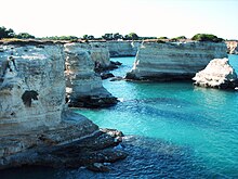
Pliocene-Quaternary volcanism in Italy occurred with the onset of extensional tectonics of backarc basins like the Tyrrhenian Sea: seamounts and island arc volcanism developed as well as on-land magmatism in Tuscany, Lazio and Campania, often aligned with NE-SW trend followed by the main normal faults of the Apenninic chain. For example, the islands of Elba is an exhumed granitic batolith over thinned continental crust, while Stromboli is a stratovolcano originated atop newly formed oceanic crust. The most recent volcanic island is Ferdinandea near Sicily, once emerged with the 1891 offshore eruption but quickly eroded below the water, remaining as the Graham Bank. Historically active volcanoes are sometimes very explosive like Vesuvius, while others like Mount Etna tend toward less explosive basaltic eruptions. [11]
Petroleum exploration in Italy began in the late 19th century and resulted in the discovery of the Caviaga gas field close to Milan in 1944. Apennine folding has created structural traps in Pliocene sand reservoirs in the Bradanic Trough, Adriatic Sea and beneath the Po Plain. In between Brescia and Milan, the stratigraphic traps are formed at the base of Pliocene transgressive rocks and then migrated into Neogene clastic rocks that were experiencing more intense tectonic activity. In some places, organic matter in Miocene flysch may have been the original source of hydrocarbon. Off of eastern Calabria (Crotone), offshore of Trapani in western Sicily and in Gagliano, northeast Sicily are flysch-derived gas condensate reservoirs.
Liassic and Triassic age carbonates and reservoirs offshore in the south Adriatic or onshore at Irpinia are hosted in Triassic dolomites. Extremely deep production more than five kilometers deep takes place east of Milan in the Malossa Field. The eastern Sicilian Gela and Ragusa oil fields are also particularly deep.
In spite of extensive extraction after World War II, Italy still retains oil and gas resources. Production rose from 13.8 million cubic metres (490 million cubic feet) of gas in 1984 and 2.2 million tonnes (2.4 million short tons) of oil to 17.4 billion cubic metres (610 billion cubic feet) and 4.3 million tonnes (4.7 million short tons) of oil by 1991, and new reserves were sound in Italy between 1992 and 1993.
Italy has extensive lignite coal from the Eocene, concentrated in Sardinia. However, extraction is limited by thin seams and complicated tectonics. Graphite anthracite is known in Carboniferous Val d'Aosta rocks and the Permian rocks of Sardinia. Both Calabria and central Italy have peat deposits from the Paleogene.
Because of the extent of mining throughout Italy's history, from Roman times to the present, many of the country's generally small mineral deposits have already been depleted. The country has small deposits of lead, sulfur, copper, zinc, silver, fluorite, barite, strontium, aluminum, gold, beryl, molybdenum, tin, uranium, iron, cobalt, chromium, titanium, mercury and astatine. Quartz, salt, feldspar, asbestos, talc, magnesite, graphite, leucite, bentonite and perlite are all extracted for industrial purposes. Historically, Italy had silver-zinc-lead mines in Monte Neve, Raibl (in the Eastern Alps), and Sardinia, mercury in north Amiata, Tuscany, fluorite and antimony in Sardinia and pyrite in Tuscany. Elba, Cogne in the Val d'Aosta valley and the Nurra Province of Sardinia all had historical iron mining. Sardinia also produced bauxite, the Western Alps asbestos and talc, Liguria and Sardinia manganese, nickel in Piemonte and copper in Val d'Aosta.
Sicily remains active as a producer of sulfur and potassium salts and aluminum production has shifted into leucitic lavas in the center of the country. [12]

The Alps form part of a Cenozoic orogenic belt of mountain chains, called the Alpide belt, that stretches through southern Europe and Asia from the Atlantic all the way to the Himalayas. This belt of mountain chains was formed during the Alpine orogeny. A gap in these mountain chains in central Europe separates the Alps from the Carpathians to the east. Orogeny took place continuously and tectonic subsidence has produced the gaps in between.

A foreland basin is a structural basin that develops adjacent and parallel to a mountain belt. Foreland basins form because the immense mass created by crustal thickening associated with the evolution of a mountain belt causes the lithosphere to bend, by a process known as lithospheric flexure. The width and depth of the foreland basin is determined by the flexural rigidity of the underlying lithosphere, and the characteristics of the mountain belt. The foreland basin receives sediment that is eroded off the adjacent mountain belt, filling with thick sedimentary successions that thin away from the mountain belt. Foreland basins represent an endmember basin type, the other being rift basins. Space for sediments is provided by loading and downflexure to form foreland basins, in contrast to rift basins, where accommodation space is generated by lithospheric extension.

The Western Carpathians are a mountain range and geomorphological province that forms the western part of the Carpathian Mountains.

The geology of the Iberian Peninsula consists of the study of the rock formations on the Iberian Peninsula, which includes Spain, Portugal, Andorra, and Gibraltar. The peninsula contains rocks from every geological period from the Ediacaran to the Quaternary, and many types of rock are represented. World-class mineral deposits are also found there.

The Western Carpathians are an arc-shaped mountain range, the northern branch of the Alpine-Himalayan fold and thrust system called the Alpide belt, which evolved during the Alpine orogeny. In particular, their pre-Cenozoic evolution is very similar to that of the Eastern Alps, and they constitute a transition between the Eastern Alps and the Eastern Carpathians.

The Pyrenees are a 430-kilometre-long, roughly east–west striking, intracontinental mountain chain that divide France, Spain, and Andorra. The belt has an extended, polycyclic geological evolution dating back to the Precambrian. The chain's present configuration is due to the collision between the microcontinent Iberia and the southwestern promontory of the European Plate. The two continents were approaching each other since the onset of the Upper Cretaceous (Albian/Cenomanian) about 100 million years ago and were consequently colliding during the Paleogene (Eocene/Oligocene) 55 to 25 million years ago. After its uplift, the chain experienced intense erosion and isostatic readjustments. A cross-section through the chain shows an asymmetric flower-like structure with steeper dips on the French side. The Pyrenees are not solely the result of compressional forces, but also show an important sinistral shearing.

The main points that are discussed in the geology of Iran include the study of the geological and structural units or zones; stratigraphy; magmatism and igneous rocks; ophiolite series and ultramafic rocks; and orogenic events in Iran.

The geology of Germany is heavily influenced by several phases of orogeny in the Paleozoic and the Cenozoic, by sedimentation in shelf seas and epicontinental seas and on plains in the Permian and Mesozoic as well as by the Quaternary glaciations.
The geology of Sicily records the collision of the Eurasian and the African plates during westward-dipping subduction of the African slab since late Oligocene. Major tectonic units are the Hyblean foreland, the Gela foredeep, the Apenninic-Maghrebian orogen, and the Calabrian Arc. The orogen represents a fold-thrust belt that folds Mesozoic carbonates, while a major volcanic unit is found in an eastern portion of the island. The collision of Africa and Eurasia is a retreating subduction system, such that the descending Africa is falling away from Eurasia, and Eurasia extends and fills the space as the African plate falls into the mantle, resulting in volcanic activity in Sicily and the formation of Tyrrhenian slab to the north.

The geology of Lebanon remains poorly studied prior to the Jurassic. The country is heavily dominated by limestone, sandstone, other sedimentary rocks, and basalt, defined by its tectonic history. In Lebanon, 70% of exposed rocks are limestone karst.
The geology of Morocco formed beginning up to two billion years ago, in the Paleoproterozoic and potentially even earlier. It was affected by the Pan-African orogeny, although the later Hercynian orogeny produced fewer changes and left the Maseta Domain, a large area of remnant Paleozoic massifs. During the Paleozoic, extensive sedimentary deposits preserved marine fossils. Throughout the Mesozoic, the rifting apart of Pangaea to form the Atlantic Ocean created basins and fault blocks, which were blanketed in terrestrial and marine sediments—particularly as a major marine transgression flooded much of the region. In the Cenozoic, a microcontinent covered in sedimentary rocks from the Triassic and Cretaceous collided with northern Morocco, forming the Rif region. Morocco has extensive phosphate and salt reserves, as well as resources such as lead, zinc, copper and silver.

The geology of Bosnia & Herzegovina is the study of rocks, minerals, water, landforms and geologic history in the country. The oldest rocks exposed at or near the surface date to the Paleozoic and the Precambrian geologic history of the region remains poorly understood. Complex assemblages of flysch, ophiolite, mélange and igneous plutons together with thick sedimentary units are a defining characteristic of the Dinaric Alps, also known as the Dinaride Mountains, which dominate much of the country's landscape.
The geology of Belgium encompasses rocks, minerals and tectonic events stretching back more than 500 million years. Belgium covers an area of about 30,507 square kilometers and was instrumental in the development of geology. The extensive outcrops in Belgium became the standard reference points in stratigraphy as early as the mid-19th century. Some of them are internationally recognized features related to the Carboniferous and the Devonian periods. These rocks were folded by two mountain building events: the Hercynian orogeny and Caledonian Orogeny. Paleozoic basement rocks cover much of the country and are overlain by Mesozoic and Cenozoic sediments.

The geology of Kyrgyzstan began to form during the Proterozoic. The country has experienced long-running uplift events, forming the Tian Shan mountains and large, sediment filled basins.

The geology of Uzbekistan consists of two microcontinents and the remnants of oceanic crust, which fused together into a tectonically complex but resource rich land mass during the Paleozoic, before becoming draped in thick, primarily marine sedimentary units.
The geology of Romania is structurally complex, with evidence of past crustal movements and the incorporation of different blocks or platforms to the edge of Europe, driving recent mountain building of the Carpathian Mountains. Romania is a country located at the crossroads of Central, Eastern, and Southeastern Europe. It borders the Black Sea to the southeast, Bulgaria to the south, Ukraine to the north, Hungary to the west, Serbia to the southwest, and Moldova to the east.

The geology of Croatia has some Precambrian rocks mostly covered by younger sedimentary rocks and deformed or superimposed by tectonic activity.
The geology of Greece is highly structurally complex due to its position at the junction between the European and African tectonic plates.
The geology of the Czech Republic is very tectonically complex, split between the Western Carpathian Mountains and the Bohemian Massif.

The geology of Peru includes ancient Proterozoic rocks, Paleozoic and Mesozoic volcanic and sedimentary rocks, and numerous basins and the Andes Mountains formed in the Cenozoic.