Related Research Articles

Cyprus is an island in the Eastern Basin of the Mediterranean Sea. It is the third largest island in the Mediterranean, after the Italian islands of Sicily and Sardinia, and the 80th largest island in the world by area. It is located south of the Anatolia peninsula, yet it belongs to the Cyprus arc. Cyprus may be included in Europe or West Asia as the island is close to Southeast Europe and the Middle East. Cyprus also had lengthy periods of mainly Greek and intermittent Anatolian, Levantine, Byzantine, Turkish and Western European influence.

An ophiolite is a section of Earth's oceanic crust and the underlying upper mantle that has been uplifted and exposed above sea level and often emplaced onto continental crustal rocks.

Dunite, also known as olivinite, is an intrusive igneous rock of ultramafic composition and with phaneritic (coarse-grained) texture. The mineral assemblage is greater than 90% olivine, with minor amounts of other minerals such as pyroxene, chromite, magnetite, and pyrope. Dunite is the olivine-rich endmember of the peridotite group of mantle-derived rocks.

The Kyrenia Mountains is a long, narrow mountain range that runs for approximately 160 km (100 mi) along the northern coast of the island of Cyprus. It is primarily made of limestone, with some marble. Its highest peak is Mount Selvili, at 1,024 m (3,360 ft). Pentadaktylos (also spelt Pentadactylos; Greek: Πενταδάκτυλος; Turkish: Beşparmak is another name for the Kyrenia Mountains, though Britannica refers to Pentadaktylos as the "western portion" of the latter, or the part west of Melounta. Pentadaktylos is so-named after one of its most distinguishing features, a peak that resembles five fingers.
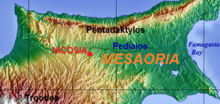
The Mesaoria is a broad, sweeping plain which makes up the north centre of the island of Cyprus.
The London-Brabant Massif or London-Brabant Platform is, in the tectonic structure of Europe, a structural high or massif that stretches from the Rhineland in western Germany across northern Belgium and the North Sea to the sites of East Anglia and the middle Thames in southern England.

The Lizard complex, Cornwall is generally accepted to represent a preserved example of an exposed ophiolite complex in the United Kingdom. The rocks found in The Lizard area are analogous to those found in such famous areas as the Troodos Mountains, Cyprus and the Semail Ophiolite, Oman.

Harzburgite, an ultramafic, igneous rock, is a variety of peridotite consisting mostly of the two minerals olivine and low-calcium (Ca) pyroxene (enstatite); it is named for occurrences in the Harz Mountains of Germany. It commonly contains a few percent chromium-rich spinel as an accessory mineral. Garnet-bearing harzburgite is much less common, found most commonly as xenoliths in kimberlite.
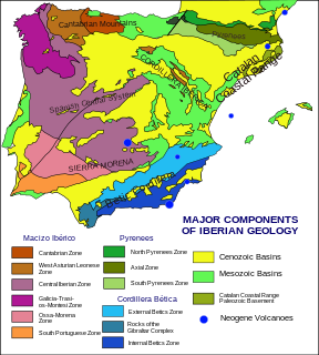
The geology of the Iberian Peninsula consists of the study of the rock formations on the Iberian Peninsula, which includes Spain, Portugal, Andorra, and Gibraltar. The peninsula contains rocks from every geological period from the Ediacaran to the Quaternary, and many types of rock are represented. World-class mineral deposits are also found there.
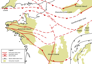
The Armorican Massif is a geologic massif that covers a large area in the northwest of France, including Brittany, the western part of Normandy and the Pays de la Loire. It is important because it is connected to Dover on the British side of the English Channel and there has been tilting back and forth that has controlled the geography on both sides.
The Massif Central is one of the two large basement massifs in France, the other being the Armorican Massif. The Massif Central's geological evolution started in the late Neoproterozoic and continues to this day. It has been shaped mainly by the Caledonian orogeny and the Variscan orogeny. The Alpine orogeny has also left its imprints, probably causing the important Cenozoic volcanism. The Massif Central has a very long geological history, underlined by zircon ages dating back into the Archaean 3 billion years ago. Structurally it consists mainly of stacked metamorphic basement nappes.
The Troodos Ophiolite on the island of Cyprus represents a Late Cretaceous spreading axis that has since been uplifted due to its positioning on the overriding Anatolian plate at the Cyprus arc and ongoing subduction to the south of the Eratosthenes Seamount.
The geology of Cyprus is part of the regional geology of Europe. Cyprus lies on the southern border of the Eurasian Plate and on the southern margin of the Anatolian Plate. The southern margin of the Anatolian Plate is in collision with the African Plate, which has created the uplift of the Cyprus arc and Cyprus itself.

The geology of Madagascar comprises a variety of rocks of Precambrian age which make up the larger part of the east and centre of the island. They are intruded by basalts and rhyolites of Mesozoic to Cenozoic age. In contrast, the western part of the island is formed from sedimentary rocks of Carboniferous to Quaternary age. Archean rocks occur from the northeast portion of the island down to the south in the Ranotsara shear zone. Rocks in the northern portion of Madagascar are greenstone belts, from the Archean or Paleoproterozoic age.

The geology of Germany is heavily influenced by several phases of orogeny in the Paleozoic and the Cenozoic, by sedimentation in shelf seas and epicontinental seas and on plains in the Permian and Mesozoic as well as by the Quaternary glaciations.
The geology of Georgia is the study of rocks, minerals, water, landforms and geologic history in Georgia. The country is dominated by the Caucasus Mountains at the junction of the Eurasian Plate and the Afro-Arabian Plate, and rock units from the Mesozoic and Cenozoic are particularly prevalent. For much of its geologic history, until the uplift of the Caucasus, Georgia was submerged by marine transgression events. Geologic research for 150 years by Georgian and Russian geologists has shed significant light on the region and since the 1970s has been augmented with the understanding of plate tectonics.

The geology of Bosnia & Herzegovina is the study of rocks, minerals, water, landforms and geologic history in the country. The oldest rocks exposed at or near the surface date to the Paleozoic and the Precambrian geologic history of the region remains poorly understood. Complex assemblages of flysch, ophiolite, mélange and igneous plutons together with thick sedimentary units are a defining characteristic of the Dinaric Alps, also known as the Dinaride Mountains, which dominate much of the country's landscape.
The geology of Belgium encompasses rocks, minerals and tectonic events stretching back more than 500 million years. Belgium covers an area of about 30507 square kilometers and was very instrumental in the development of geology. For instance, the extensive outcrops in Belgium became the standard reference points in stratigraphy in as early as the mid-19th century. Some of them are internationally recognized features related to the Carboniferous and the Devonian. These rocks were folded by two orogeny mountain building events --the Hercynian orogeny, and Caledonian Orogeny. Paleozoic basement rocks cover much of the country and are overlain by Mesozoic and Cenozoic sediments.

The geology of Uzbekistan consists of two microcontinents and the remnants of oceanic crust, which fused together into a tectonically complex but resource rich land mass during the Paleozoic, before becoming draped in thick, primarily marine sedimentary units.
The geology of Greece is highly structurally complex due to its position at the junction between the European and African tectonic plates.
References
- ↑ Moores, E.M.; Fairbridge, Rhodes W. (1997). Encyclopedia of European & Asian Regional Geology. Springer. p. 161-165.
| | This Northern Cyprus-related article is a stub. You can help Wikipedia by expanding it. |