
Sedimentary rocks are types of rock that are formed by the accumulation or deposition of mineral or organic particles at Earth's surface, followed by cementation. Sedimentation is the collective name for processes that cause these particles to settle in place. The particles that form a sedimentary rock are called sediment, and may be composed of geological detritus (minerals) or biological detritus. The geological detritus originated from weathering and erosion of existing rocks, or from the solidification of molten lava blobs erupted by volcanoes. The geological detritus is transported to the place of deposition by water, wind, ice or mass movement, which are called agents of denudation. Biological detritus was formed by bodies and parts of dead aquatic organisms, as well as their fecal mass, suspended in water and slowly piling up on the floor of water bodies. Sedimentation may also occur as dissolved minerals precipitate from water solution.

The geology of the Zion and Kolob canyons area includes nine known exposed formations, all visible in Zion National Park in the U.S. state of Utah. Together, these formations represent about 150 million years of mostly Mesozoic-aged sedimentation in that part of North America. Part of a super-sequence of rock units called the Grand Staircase, the formations exposed in the Zion and Kolob area were deposited in several different environments that range from the warm shallow seas of the Kaibab and Moenkopi formations, streams and lakes of the Chinle, Moenave, and Kayenta formations to the large deserts of the Navajo and Temple Cap formations and dry near shore environments of the Carmel Formation.

The Los Angeles Basin is a sedimentary basin located in Southern California, in a region known as the Peninsular Ranges. The basin is also connected to an anomalous group of east-west trending chains of mountains collectively known as the Transverse Ranges. The present basin is a coastal lowland area, whose floor is marked by elongate low ridges and groups of hills that is located on the edge of the Pacific Plate. The Los Angeles Basin, along with the Santa Barbara Channel, the Ventura Basin, the San Fernando Valley, and the San Gabriel Basin, lies within the greater Southern California region. The majority of the jurisdictional land area of the city of Los Angeles physically lies within this basin.

The exposed geology of the Capitol Reef area presents a record of mostly Mesozoic-aged sedimentation in an area of North America in and around Capitol Reef National Park, on the Colorado Plateau in southeastern Utah.

The geology of the Australian Capital Territory includes rocks dating from the Ordovician around 480 million years ago, whilst most rocks are from the Silurian. During the Ordovician period the region—along with most of eastern Australia—was part of the ocean floor. The area contains the Pittman Formation consisting largely of quartz-rich sandstone, siltstone and shale; the Adaminaby Beds and the Acton Shale.

Clastic rocks are composed of fragments, or clasts, of pre-existing minerals and rock. A clast is a fragment of geological detritus, chunks, and smaller grains of rock broken off other rocks by physical weathering. Geologists use the term clastic to refer to sedimentary rocks and particles in sediment transport, whether in suspension or as bed load, and in sediment deposits.

The Roxbury Conglomerate, also informally known as Roxbury puddingstone, is a name for a rock formation that forms the bedrock underlying most of Roxbury, Massachusetts, now part of the city of Boston. The bedrock formation extends well beyond the limits of Roxbury, underlying part or all of Quincy, Canton, Milton, Dorchester, Dedham, Jamaica Plain, Brighton, Brookline, Newton, Needham, and Dover. It is named for exposures in Roxbury, in the Boston area. It is the Rock of the Commonwealth in Massachusetts.
The Cadomian Orogeny was a tectonic event or series of events in the late Neoproterozoic, about 650–550 Ma, which probably included the formation of mountains. This occurred on the margin of the Gondwana continent, involving one or more collisions of island arcs and accretion of other material at a subduction zone. The precise events, and geographical position, are uncertain, but are thought to involve the terranes of Avalonia, Armorica and Iberia. Rocks deformed in the orogeny are found in several areas of Europe, including northern France, the English Midlands, southern Germany, Bohemia, southern Poland and the southwest Iberian Peninsula. The name comes from Cadomus, the Latin name for Caen, northern France. L Bertrand gave the orogeny its name in 1921, naming it after Cadomus the Gaulish name for Caen in Normandy. He defined the end as being marked by Lower Palaeozoic red beds.
The Mount Pleasant Caldera is a large eroded Late Devonian volcanic caldera complex, located in the northern Appalachian Mountains of southwestern New Brunswick, Canada. It is one of few noticeable pre-Cenozoic calderas, and its formation is associated to a period of crustal thinning that followed the Acadian orogeny in the northern Appalachian Mountains. It sits relatively near to the coastline.
This glossary of geology is a list of definitions of terms and concepts relevant to geology, its sub-disciplines, and related fields. For other terms related to the Earth sciences, see Glossary of geography terms.
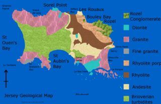
The geology of Jersey is characterised by the Late Proterozoic Brioverian volcanics, the Cadomian Orogeny, and only small signs of later deposits from the Cambrian and Quaternary periods. The kind of rocks go from conglomerate to shale, volcanic, intrusive and plutonic igneous rocks of many compositions, and metamorphic rocks as well, thus including most major types.

The geology of Tasmania is complex, with the world's biggest exposure of diabase, or dolerite. The rock record contains representatives of each period of the Neoproterozoic, Paleozoic, Mesozoic and Cenozoic eras. It is one of the few southern hemisphere areas that were glaciated during the Pleistocene with glacial landforms in the higher parts. The west coast region hosts significant mineralisation and numerous active and historic mines.

The Hebridean Terrane is one of the terranes that form part of the Caledonian orogenic belt in northwest Scotland. Its boundary with the neighbouring Northern Highland Terrane is formed by the Moine Thrust Belt. The basement is formed by Archaean and Paleoproterozoic gneisses of the Lewisian complex, unconformably overlain by the Neoproterozoic Torridonian sediments, which in turn are unconformably overlain by a sequence of Cambro–Ordovician sediments. It formed part of the Laurentian foreland during the Caledonian continental collision.
Fujian is a south eastern coastal province of China. The eastern half of the province is largely covered by Jurassic Period acid volcanic rocks and Cretaceous tuffaceous sandstone. However, there are rocks of a variety of ages including the oldest around 1800 Ma. The deposits from the Triassic are predominantly on land, whereas the older ones are marine sediments.
The Wentnor Group is a group of rocks associated with the Longmyndian Supergroup of Precambrian age in present-day Wales, U.K.
The Stretton Group is a group of rocks associated with the Longmyndian Supergroup of Ediacaran age, in Shropshire, England. The rocks are located within the tract between two elements of the Welsh Borderland Fault System, the Church Stretton Fault and the Pontesford-Linley Lineament.

The geology of the Isle of Skye in Scotland is highly varied and the island's landscape reflects changes in the underlying nature of the rocks. A wide range of rock types are exposed on the island, sedimentary, metamorphic and igneous, ranging in age from the Archaean through to the Quaternary.

The Dox Formation, also known as the Dox Sandstone, is a Mesoproterozoic rock formation that outcrops in the eastern Grand Canyon, Coconino County, Arizona. The Dox Formation comprises the bulk of the Unkar Group, the older subdivision of the Grand Canyon Supergroup. The Unkar Group is about 1,600 to 2,200 m thick and composed of, in ascending order, the Bass Formation, Hakatai Shale, Shinumo Quartzite, Dox Formation, and Cardenas Basalt. The Unkar Group is overlain in ascending order by the Nankoweap Formation, about 113 to 150 m thick; the Chuar Group, about 1,900 m (6,200 ft) thick; and the Sixtymile Formation, about 60 m (200 ft) thick. The entire Grand Canyon Supergroup overlies deeply eroded granites, gneisses, pegmatites, and schists that comprise Vishnu Basement Rocks.
The geology of Northumberland in northeast England includes a mix of sedimentary, intrusive and extrusive igneous rocks from the Palaeozoic and Cenozoic eras. Devonian age volcanic rocks and a granite pluton form the Cheviot massif. The geology of the rest of the county is characterised largely by a thick sequence of sedimentary rocks of Carboniferous age. These are intruded by both Permian and Palaeogene dykes and sills and the whole is overlain by unconsolidated sediments from the last ice age and the post-glacial period. The Whin Sill makes a significant impact on Northumberland's character and the former working of the Northumberland Coalfield significantly influenced the development of the county's economy. The county's geology contributes to a series of significant landscape features around which the Northumberland National Park was designated.
Ilocos-Central Luzon Basin is a sedimentary basin and stratigraphic formation in the Ilocos Region and Central Luzon Region, Philippines. It is one of the 16 major sedimentary basins in the country and stretches from the vicinity of the Manila metropolitan area in the south to Ilocos Norte in the north.