A town council, city council or municipal council is a form of local government for small municipalities.

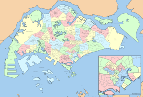
Ang Mo Kio (IPA:/ɑːŋmoʊkjoʊ/ is a planning area and residential town situated in the Central Region of Singapore. Located approximately 11 km north of the Downtown Core district, Ang Mo Kio is the 3rd most populated planning area in the North-East region and ranks 8th in terms of population in the country overall. The planning area is located at the south-western corner of the North-East region, bordered by the planning areas of Yishun to the north, Sengkang to the north-east, Serangoon to the east, Bishan to the south and the Central Water Catchment to the west.

The Housing & Development Board, is a statutory board under the Ministry of National Development responsible for the public housing in Singapore. Established in 1960 as a result of efforts in the late 1950s to set up an authority to take over the Singapore Improvement Trust's (SIT) public housing responsibilities, the HDB focused on the construction of emergency housing and the resettlement of kampong residents into public housing in the first few years of its existence.

Kallang (IPA:/kɑːlɑːŋ/ is a planning area and residential zone located in the Central Region of Singapore.

Bukit Panjang is a planning area and residential town located in the West Region of Singapore. A portion of this town is situated on a low-lying elongated hill. The planning area is bounded by Bukit Batok to the west, Choa Chu Kang to the northwest, Sungei Kadut to the north, the Central Water Catchment to the east, and Bukit Timah to the south. Bukit Panjang New Town is located at the northern portion of the planning area. Bukit Panjang has an average elevation of 36m/118 ft.

Bedok is a planning area and residential town located in the geographical region of Tanah Merah along the south-eastern coast of the East Region of Singapore. Bedok is bounded by five other planning areas: Paya Lebar to the north, Hougang to the northwest, Tampines to the northeast and east, Geylang to the west and Marine Parade to the southwest. It also shares a maritime boundary with the Singapore Strait to the south and southeast.
Bukit Merah, also known as Redhill, is a planning area and new town situated in the southernmost part of the Central Region of Singapore. The planning area borders Tanglin to the north, Queenstown to the west and the Downtown Core, Outram and Singapore River planning areas of the Central Area to the east. It also shares a maritime boundary with the Southern Islands planning area to the south. Bukit Merah is linked to Sentosa Island via Sentosa Gateway, Sentosa Broadwalk, Sentosa Express and the Cable Car.

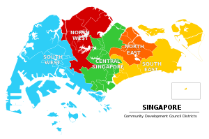
The Community Development Council is a government-led organisation to organise grassroot organisations and community programmes into smaller, local units as a bridge between the government and the community in Singapore. It encourages volunteerism from wider community, and organises community and social assistance programs with the help of a monetary grant from the government. They are governed by the Community Development Council Rules 1997.

Sengkang is a planning area and residential town located in the North-East Region of Singapore. The town is the second most populous in the region, being home to 249,370 residents in 2020. Sengkang shares boundaries with Seletar and Punggol in the north, Pasir Ris and Paya Lebar in the east, Hougang and Serangoon to the south, as well as Yishun and Ang Mo Kio to the west.

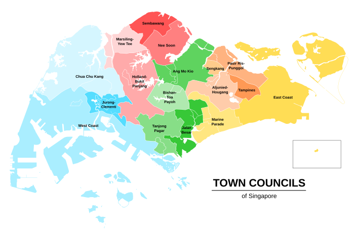
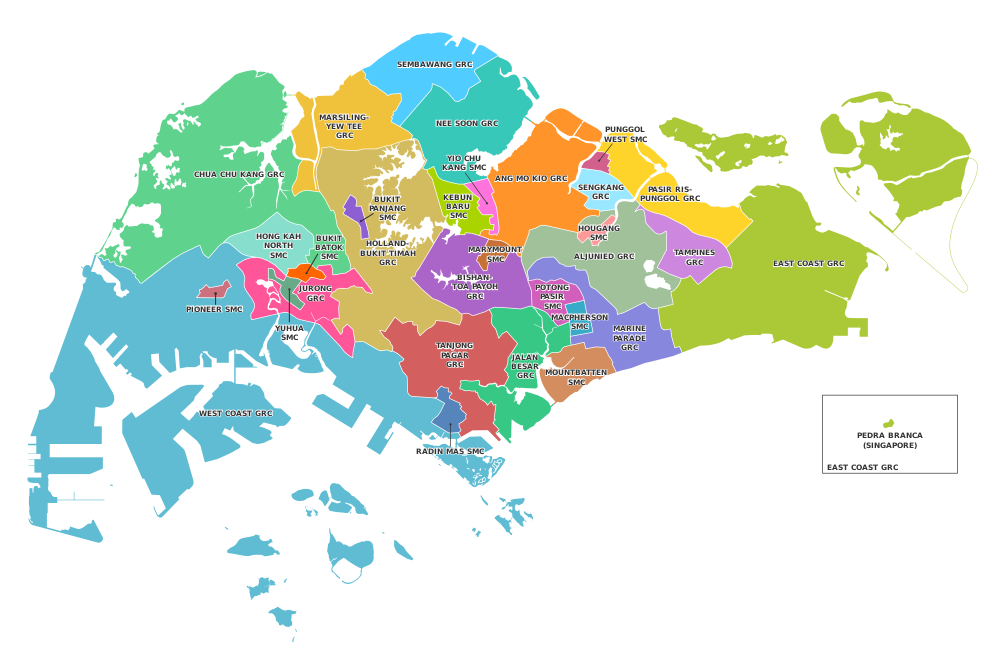
The Pasir Ris–Punggol Group Representation Constituency is a five-member Group Representation Constituency (GRC) in the north-eastern region of Singapore. The constituency currently consists of Pasir Ris and parts of the Punggol town area. The GRC comprises 5 constituencies: Pasir Ris Central, Pasir Ris East, Pasir Ris West, Punggol Shore as well as Punggol Coast managed by Pasir Ris—Punggol Town Council. The current MPs are Sharael Taha, Desmond Tan, Teo Chee Hean, Yeo Wan Ling and Janil Puthucheary from the People's Action Party (PAP).

A group representation constituency (GRC) is a type of electoral division or constituency in Singapore in which teams of candidates, instead of individual candidates, compete to be elected into Parliament as the Members of Parliament (MPs) for the constituency. Synonymous to the party block voting (PBV) or the general ticket used in other countries, the Government stated that the GRC scheme was primarily implemented to enshrine minority representation in Parliament: at least one of the MPs in a GRC must be a member of the Malay, Indian or another minority community of Singapore. In addition, it was economical for town councils, which manage public housing estates, to handle larger constituencies.
Teo Ho Pin is a Singaporean former politician who served as Mayor of North West District between 2001 and 2020.
Whampoa Single Member Constituency was a single member constituency (SMC) located in the eastern region of Singapore. The constituency covers the main area of Whampoa.

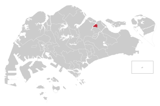
The Kebun Baru Single Member Constituency is a single member constituency in Ang Mo Kio, Singapore. It is managed by Ang Mo Kio Town Council. The current Member of Parliament for the constituency is People's Action Party (PAP) Henry Kwek.

General elections were held in Singapore on Friday, 11 September 2015 to elect 89 members of Parliament. The outgoing Parliament had been dissolved and the general election called by President Tony Tan on 25 August, on the advice of Prime Minister Lee Hsien Loong. The elections were for the 13th Parliament since independence in 1965, using the first-past-the-post electoral system.

General elections were held in Singapore on Friday, 10 July 2020 to elect 93 members to the Parliament of Singapore across 31 constituencies. Parliament was dissolved and the general election called by President Halimah Yacob on 23 June, on the advice of Prime Minister Lee Hsien Loong. It elected members of parliament to the 14th Parliament of Singapore since Singapore's independence in 1965, using the first-past-the-post electoral system.

The Sengkang Group Representation Constituency is a four-member Group Representation Constituency (GRC) in the north-eastern region of Singapore. It consists of Punggol East SMC, Sengkang West SMC and what was previously the Sengkang Central ward of the Pasir Ris–Punggol GRC. Sengkang GRC consists of four divisions: Anchorvale, Rivervale, Buangkok, and Compassvale managed by Sengkang Town Council. The current Members of Parliament are He Ting Ru, Jamus Lim and Louis Chua from the Workers' Party (WP) after the resignation of Raeesah Khan.
The Punggol West Single Member Constituency (SMC) is a Single Member Constituency located in the north-eastern area of Singapore formed in 2020. It is managed by Pasir Ris — Punggol Town Council. The current Member of Parliament (MP) is Sun Xueling of the People's Action Party (PAP).
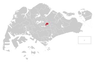
The Marymount Single Member Constituency is a single member constituency (SMC) located in the central area of Singapore formed in 2020. It is managed by Bishan-Toa Payoh Town Council. The current Member of Parliament (MP) is Gan Siow Huang of the People's Action Party (PAP).