Related Research Articles

Yishun, formerly known as Nee Soon, is a residential town located in the northeastern corner of the North Region of Singapore, bordering Simpang and Sembawang to the north, Mandai to the west, the Central Water Catchment to its southwest, Ang Mo Kio to its south, as well as Seletar and Sengkang to its east.
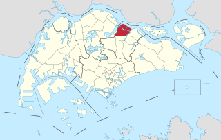
Seletar is an area located in the north-east of Singapore. Its name can also refer to the Seletar Planning Area, situated in the North-East Region of Singapore. The place name was derived from the Malay subgroup who were indigenous to the area, the Orang Seletar. It shares boundaries with the planning areas of Sengkang to the south, Punggol to the east, Yishun and Simpang to the west, as well as the Straits of Johor to the north.
Kranji is a suburb in northwestern Singapore, bounded by Sungei Kadut to the north, Turf Club to the east, as well as Lim Chu Kang and the Western Water Catchment to the west.

Kranji Reservoir is a reservoir in the northern part of Singapore, near the Straits of Johor. It was a former freshwater river that flowed out into the sea that was dammed at its mouth to form a freshwater reservoir. It can also be classified as an estuary. The dam has a road bridging the two banks, and now prevents the sea from coming in, and is home to a marsh. The former Kranji River has three main tributaries - Sungei Peng Siang, Sungei Kangkar and Sungei Tengah.
Lower Seletar Reservoir is a reservoir located in the northern part of Singapore, to the east of Yishun New Town. The reservoir has a surface area of 3.6 km², and a capacity of 9.5 million m³. The mean depth of the reservoir is 2 m, with a maximum depth of 5.5 m. The shoreline length is 14.3 km.
JTC Corporation (JTC), formerly the Jurong Town Corporation, is a statutory board under the Ministry of Trade and Industry that champions sustainable industrial development. It masterplans clean, green and smart estates to create attractive destinations for Singapore's talent and communities. The agency also drives innovations in the building and infrastructure sector.
Water supply and sanitation in Singapore is characterised by a number of challenging environments that have been achieved in a relatively small country with geographical limitations. Despite these challengess, access to water in Singapore is considered universal, affordable, efficient and of high quality.

Upper Seletar Reservoir is Singapore's third impounding reservoir, after MacRitchie Reservoir and Peirce Reservoir. It is located within the Central Water Catchment area of Singapore island.
The Public Utilities Board (PUB) is a statutory board under the Ministry of Sustainability and the Environment of the Government of Singapore responsible for ensuring a sustainable and efficient water supply in Singapore.
Singapore has about 65 species of mammals, 390 species of birds, 110 species of reptiles, 30 species of amphibians, more than 300 butterfly species, 127 dragonfly species, and over 2,000 recorded species of marine wildlife.
Pasir Laba Camp is an installation of the Singapore Armed Forces. It is composed primarily of Army tenant units, apart from tri-service SAF Warrant Officer School. It is considered the home of the Warrant Officer and Specialist Corps, just as SAFTI Military Institute is the home of the Officer Corps.

The Western Water Catchment is a planning area located in the West Region of Singapore. The planning area borders Tuas and Pioneer to its south, Sungei Kadut, Choa Chu Kang and Tengah to its east, Jurong West to its southeast, Lim Chu Kang to its north and the Straits of Johor to its west.

Rochor River is a canalised river in Kallang of the Central Region in Singapore. The river is about 0.8 km in length.

Serangoon Harbour is a harbour in Singapore located between the mainland island of Singapore and Pulau Ubin.

The Battle of Kranji was the second stage of the Empire of Japan's plan for the invasion of Singapore during the Second World War. On 9 February 1942 the Imperial Japanese Army assaulted the north-western front of Singapore, capital of the Straits Settlements.
Choa Chu Kang Road is a road in Singapore presently in two sections.

Sungei Kadut is an industrial estate and planning area located in the North Region of Singapore. It is bounded by Bukit Panjang and Choa Chu Kang to the south, Mandai to the east, as well as Lim Chu Kang and the Western Water Catchment to the west. Its northern boundary is defined by the Straits of Johor.
References

| Sovereign states |
|
|---|---|
| States with limited recognition | |
| Dependencies and other territories | |