Related Research Articles

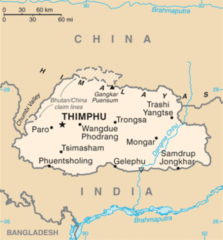
Bhutan is a sovereign country at the crossroads of East Asia and South Asia, located towards the eastern extreme of the Himalayas mountain range. It is fairly evenly sandwiched between the sovereign territory of two nations: first, the People's Republic of China (PRC) on the north and northwest. There are approximately 477 kilometres (296 mi) of border with the country's Tibet Autonomous Region (TAR), or simply Tibet. The second nation is the Republic of India on the south, southwest, and east; there are approximately 659 kilometres (409 mi) with the states of Arunachal Pradesh, Assam, West Bengal, and Sikkim, in clockwise order from the kingdom. Bhutan's total borders amount to approximately 1,139 kilometres (708 mi). The Indian state of Sikkim to the west, the India to the south, and the Assam state of India to the southeast are other close neighbours; the former two are separated by only very small stretches of Indian territory.
Manas may refer to:

Mongar District is one of the 20 dzongkhags (districts) comprising Bhutan. Mongar is the fastest-developing dzongkhag in eastern Bhutan. A regional hospital has been constructed and the region is bustling with many economic activities. Mongar is noted for its lemon grass, a plant that can be used to produce an essential oil. It also has a hydroelectric power-plant on the Kuri Chhu river. Mongar is notable for having the longest work time in all the dzongkhags of Bhutan.
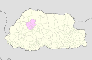
Punakha District is one of the 20 dzongkhags (districts) comprising Bhutan. It is bordered by Thimphu, Gasa, and Wangdue Phodrang Districts. The dominant language in the district is Dzongkha, the national language.
Mangde Chhu or Tongsa river flows in central Bhutan traversing roughly north–south. The river rises in Wangdue Phodrang district, near Gangkhar Puensum, Bhutan's highest peak at 7,546 metres (24,757 ft). Bhutan's main east–west highway crosses the Mangde Chhu about 8 kilometres (5 mi) west of Trongsa. South of Trongsa, the river drains the eastern slopes of the Black Mountains (Bhutan), and forms the eastern boundaries of Black Mountain National Park and Royal Manas National Park. Another highway follows the river south from Trongsa to Shemgang. The highway leaves the river at Tingtinbi, and eventually reaches the Indian border at Gelegphug. South of Tingtinbi, the Mangde is joined by the Bumthang River from the east, and is known as the Tongasa. Shortly before entering India in Assam, the Manas River flows into the river from the east, and the river exits Bhutan near Manas.
Bumthang River is a river in Bhutan. It joins the Tongsa Chhu or Mangde Chhu in southern Bhutan and the combined stream flows into the Manas River.

The Torsa River rises from the Chumbi Valley in Tibet, China, where it is known as Machu. Its course continues into Bhutan, India, and Bangladesh before joining the Brahmaputra River into the Bay of Bengal.

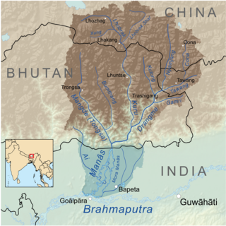
The Manas River, known in Bhutan as the Drangme Chhu, is a transboundary river in the Himalayan foothills between southern Bhutan, India, and China. It is the largest of Bhutan's four major river systems, with the other three being the Amo Chu or Torsa River, the Wang Chu or Raidak, and the Puna Tshang Chu or Sankosh. It is met by three other major streams before it again debouches into India in western Assam. The river flows for a total length of 400 kilometres (250 mi), including through Tibet for 24 km (15 mi), Bhutan for 272 kilometres (169 mi), and Assam for 104 kilometres (65 mi) before it joins the mighty Brahmaputra River at Jogighopa. A major tributary of the Manas, the Aie River, joins it in Assam at Bangpari.

The Raidāk River, also called Wang Chhu or Wong Chhu in Bhutan, is a trans-boundary river originating in Bhutan that is a tributary of the River Brahmaputra. It flows through Bhutan, India and Bangladesh. It is one of the main rivers in Alipurduar District, West Bengal, India.
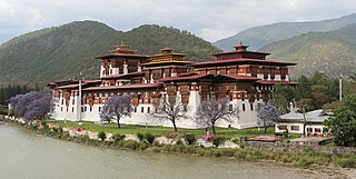
The Punakha Dzong, also known as Pungthang Dewa chhenbi Phodrang, is the administrative centre of Punakha District in Punakha, Bhutan. Constructed by Ngawang Namgyal, 1st Zhabdrung Rinpoche, in 1637–38, it is the second oldest and second-largest dzong in Bhutan and one of its most majestic structures. The dzong houses the sacred relics of the southern Drukpa Lineage of the Kagyu school of Tibetan Buddhism, including the Rangjung Kharsapani and the sacred remains of Ngawang Namgyal and the tertön Pema Lingpa.
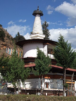
Jangtsa Dumgtseg Lhakhang[zlum brtshegs lha khang] is a Buddhist temple in western Bhutan. The temple is notable as it is in the form of a chorten, very rare in Bhutan. It is located on the edge of a hill between the Paro valley and the Dopchari valley, across the bridge from Paro. The Buddhist iconography depicted in the Chorten is considered a unique repository of the Drukpa Kagyu school.

Lhuentse Dzong is a dzong and Buddhist monastery in Lhuentse District in eastern Bhutan. It lies on the eastern side of the Kuri Chhu and is perched on a spur at the end of a narrow valley.

The Kuri Chhu, also known as the Lhozhag Xung Qu or Norbu Lag Qu, is a major river of eastern Bhutan, that has formed a scenic valley with high peaks and steep hills. Kuri Chhu is a tributary of the Manas River system, which is the largest river of Bhutan and a major tributary of the Brahmaputra River that drains most of eastern Bhutan.

The Paro Chhu is a river of western Bhutan. It is a tributary of the Wong Chhu, which is known as the Raidak in its lower reaches.

The Ha Chhu is a river in west-central Bhutan, it is a tributary of the Raidak River.
The Tang Chuu is a tributary of the Mo Chhu in western Bhutan.
This is a list of the extreme points of Bhutan.
The glaciers in Bhutan, which covers about 3 percent of the total surface area, are responsible for feeding all rivers of Bhutan except the Amochu and Nyere Amachu.
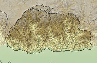
The mountains of Bhutan are some of the most prominent natural geographic features of the kingdom. Located on the southern end of the Eastern Himalaya, Bhutan has one of the most rugged mountain terrains in the world, whose elevations range from 160 metres (520 ft) to more than 7,000 metres (23,000 ft) above sea level, in some cases within distances of less than 100 kilometres (62 mi) of each other. Bhutan's highest peak, at 7,570 metres (24,840 ft) above sea level, is north-central Gangkhar Puensum, close to the border with Tibet; the third highest peak, Jomolhari, overlooking the Chumbi Valley in the west, is 7,314 metres (23,996 ft) above sea level; nineteen other peaks exceed 7,000 metres (23,000 ft). Weather is extreme in the mountains: the high peaks have perpetual snow, and the lesser mountains and hewn gorges have high winds all year round, making them barren brown wind tunnels in summer, and frozen wastelands in winter. The blizzards generated in the north each winter often drift southward into the central highlands.

Tawang Chu is the main river of the Tawang district in Arunachal Pradesh, India. The entire district may be regarded as the basin of the Tawang Chu river. In addition, two south-flowing rivers from Tibet, viz., the Tsona Chu and Nyamjang Chu, join the river within the district. The combined river flows west into Bhutan, where it progresses to the Manas River and flows into the Assam state of India.
References
- 1 2 3 4 Tibet Handbook. Footprint Handbooks. 1999. p. 872. ISBN 9781900949330 . Retrieved 2010-05-10.
- 1 2 3 4 5 6 7 8 9 10 11 12 "Physiological Survey". River System of Bhutan. FAO Corporate Document Repository. Retrieved 2010-05-09.
- ↑ "Rivers and Lakes". Archived from the original on 2008-06-08. Retrieved 2010-05-09.
- ↑ "Potential Development Challenges in the Rivers of Bhutan" (PDF). Retrieved 2010-05-09.[ dead link ]
- ↑ Assessment Report, Department of Energy of Bhutan Archived 2012-06-06 at the Wayback Machine
- 1 2 "Geonet Names Server". National Geospatial Intelligence Agency. Retrieved 2010-05-10.
| Authority control databases: National |
|---|