Torsa River

Last updated

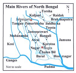
Torsa River
Machu, Amo Chhu
Torsa in coochbehar.JPG
Torsa River near Cooch Behar
BD Map Rivers of North Bengal2.jpg
Location
Country China, Bhutan, India, Bangladesh
Cities Phuntsholing, Jaigaon, Hasimara, Cooch Behar
Physical characteristics
Mouth Brahmaputra River
Length358 km (222 mi)
Basin features
Tributaries 
  left Kaljani

The Torsa River (also spelt Torsha and also known as Kambu Maqu, Machu and Amo Chhu) rises from the Chumbi Valley in Tibet, China, where it is known as Machu. Its course continues into Bhutan, India, and Bangladesh before joining the Brahmaputra River into the Bay of Bengal.

Contents

Course

From Tibet, the Torsa flows into Bhutan, where it is known as the Amo Chu. It has a length of 358 kilometres (222 mi) before entering India, of which 113 kilometres (70 mi) are in Tibet and 145 kilometres (90 mi) in Bhutan. After entering West Bengal in India, it is known as the Torsa. In Bangladesh too, it is known by the same name. [1] It is also known as Chumbi, Am-Chu, and Jaldhaka. [2]

Afterwards, the river flows past the border towns of Phuntsholing (in Bhutan) and Jaigaon, and Hasimara (in India) and past the tea estate of Dalsingpara and the Jaldapara National Park. Ghargharia river meets with Torsa in the Tufanganj subdivision, near Deocharai and Balarampur. Torsa meets with Kaljani and then flows into Bangladesh by the name of Kaljani and meets with Brahmaputra in BD. A distributary known as the Buri Torsa meets Jaldhaka.[ citation needed ]

Ghargharia river meets with the Torsa in the Tufanganj subdivision, near Deocharai and the Balarampur Torsa meets with the Kaljani and then flows into Bangladesh by the name of the Kaljani and meets with the Jamuna there.[ clarification needed ]

Major towns and cities

The major towns along the river's banks are:

Hydro projects

Floods

The Torsha River, along with the Jaldhaka River and Teesta River, has created major flooding multiple times in Bangladesh during the monsoon season between June and September. [3]

Related Research Articles

<span class="mw-page-title-main">Cooch Behar district</span> District in West Bengal, India

Cooch Behar district is a district of the Indian state of West Bengal.

<span class="mw-page-title-main">Alipurduar</span> City in West Bengal, India

Alipurduar is a city and a municipality in the Indian state of West Bengal. It is the headquarters of the Alipurduar district. Situated on the east bank of Kaljani River in the foothills of the Himalayas, the city is a gateway to Bhutan and the northeastern states of India. Alipurduar was a sub-divisional town of Jalpaiguri district until 2014 when it was created a separate district.

<span class="mw-page-title-main">Jaldhaka River</span> River in *India *Bhutan *Bangladesh

E

<span class="mw-page-title-main">Jaigaon</span> Census Town in West Bengal, India

Jaigaon is a census town in Alipurduar subdivision under Kalchini Block of Alipurduar district in the state of West Bengal, India. It is located on the country's border with Bhutan, and Bhutan Gate separates the two countries. Phuentsholing is the Bhutan's nearest city to Jaigaon. Bhutan does not have domestic roads linking all its towns, so it uses roads passing through Jaigaon to reach destinations such as Samtse, Gomtu, Nganglam and Samdrup Jongkhar.

<span class="mw-page-title-main">Hasimara</span> Town in West Bengal, India

Hasimara is a town in Alipurduar district of West Bengal state, India near the border with Bhutan. It is located at 26° 45' N latitude and 89° 21' E longitude at an altitude of 109 metres above sea level and has a population of about 40,000.

<span class="mw-page-title-main">Yatung</span> Town in Tibet, China

Yatung or Yadong, also known as Shasima , is the principal town in the Chumbi Valley or Yadong County in the Tibet Autonomous Region of China. It is also its administrative headquarters.

Madhu Tea Garden is a village in the Kalchini CD block in the Alipurduar subdivision of the Alipurduar district in West Bengal, India

<span class="mw-page-title-main">Jayanti, Alipurduar</span> Hills-cum-Village in West Bengal, India

Jayanti is a village in the Kumargram CD block in the Alipurduar subdivision of the Alipurduar district in West Bengal, India. It is one of the most famous tourist destinations of Dooars. Jayanti shares a border between India and Bhutan.

Bji Gewog is a gewog of Haa District, Bhutan. It is the northernmost gewog of the Haa District, bordering China's Chumbi Valley. The gewog has mostly mountainous terrain, with rivers flowing into Amo Chu in the west and the Ha Chu in the east. China claims a large part of the gewog as its territory and has recently started building roads and villages in the border areas.

<span class="mw-page-title-main">Tufanganj I</span> Community development block in West Bengal, India

Tufanganj I is a community development block that forms an administrative division in the Tufanganj subdivision of the Cooch Behar district in the Indian state of West Bengal.

<span class="mw-page-title-main">Torsa Strict Nature Reserve</span> Nature reserve in Bhutan

The Torsa Strict Nature Reserve (officially Jigme Khesar Strict Nature Reserve) in Bhutan covers 609.51 square kilometres in Haa District, occupying most of its area. Founded along with other national parks in 1993 by decision of the royal government, It borders Sikkim and Tibet to the west and is connected to Jigme Dorji National Park via a "biological corridor." Torsa SNR contains the westernmost temperate forests of Bhutan, from broadleaf forests to alpine meadows and the small lakes of Sinchulungpa, at altitudes ranging from 1,400 metres (4,600 ft) to 4,800 metres (15,700 ft). Like Phibsoo Wildlife Sanctuary, Torsa SNR has no resident human population.

<span class="mw-page-title-main">Bhutan–India border</span> International border

The Bhutan–India border is the open international border separating the Kingdom of Bhutan from the Republic of India. The border is 699 km long, and adjoins the Indian states of Assam, Arunachal Pradesh, West Bengal, and Sikkim.

Raimatang is a village in the Kalchini CD block in the Alipurduar subdivision of the Alipurduar district in West Bengal, India. It is about 45 kilometres (28 mi) away from Alipurduar and is a tourist destination. It is part of Buxa Tiger Reserve.It is one of the important picnic spots in Alipurduar district.

<span class="mw-page-title-main">Gipmochi</span> Mountain in India/Bhutan

Gipmochi is a mountain in the Lower Himalayas in south central Asia. Rising to a height of 14,523 feet (4,427 m), the mountain sits on the border between the northern Indian state of Sikkim and Bhutan. China claims Gipmochi as the China–India–Bhutan tri-junction point. Bhutan and India, however, claim that the tri-junction is 6.5 km to the north, at Batang La.

<span class="mw-page-title-main">Kaljani River</span>

Kaljani River is a tributary of Torsha river, originated in Bhutan at the foothills of the Himalayas and it flows from north to south via Bhutan & India and converges with Torsha river that again converges with Brahmaputra river which converges with Padma river that merges with Bay of Bengal. Kaljani river and its tributaries are attractions of the Dooars[] Major tributaries of Kaljani are Dima, Nonai, etc. The major portion of the river flows through the Indian state West Bengal. In 1993, towns like Alipurduar, Hamiltanganj on its bank was flooded when retaining wall of dam leaked and thrashed while letting the river enter in town killing hundreds of people and animals.

<span class="mw-page-title-main">Doklam</span> Disputed area between China and Bhutan

Doklam, called Donglang by China, is an area in Bhutan with a high plateau and a valley, lying between China's Chumbi Valley to the north, Bhutan's Ha District to the east and India's Sikkim state to the west. It has been depicted as part of Bhutan in the Bhutanese maps since 1961, but it is also claimed by China. The dispute has not been resolved despite several rounds of border negotiations between Bhutan and China. The area is of strategic importance to all three countries.

Jashodanga is a village in the Alipurduar II CD block in the Alipurduar subdivision of the Alipurduar district in the state of West Bengal, India.

<span class="mw-page-title-main">Rinchengang</span> Town in Yadong, China

Rinchengang (Tibetan: རིན་ཆེན་སྒང, Wylie: rin chen sgang, THL: rin chen gang, ZYPY: Rinqêngang) or Renqinggang (Chinese: 仁青岗村; pinyin: Rén qīng gǎng cūn) is a town in the Chumbi Valley and the headquarters of the Xia Yadong Township of Yadong County, Tibet region of China. It is in the valley of Amo Chu where the route from Sikkim's Jelep La pass meets Amo Chu. It is also close to the Bhutan–China border, which is currently in dispute. In December 2018, Rinchengang village had a population of around 550 people. The inhabitants are engaged in animal grazing or work as forest rangers. Some also carry supplies to Chinese border troops.

References

  1. Bandopadhyay, Dilip Kumar, Bharater Nadi (Rivers of India), 2002, (in Bengali), p. 78, Bharati Book Stall, 6B Ramanath Mazumdar Street, Kolkata.
  2. "Torsa River". banglapedia.org. Retrieved 11 May 2022.
  3. "Several thousand houses inundated in Kurigram". 28 August 2021.

Further reading

26°16′44″N89°34′48″E / 26.279°N 89.580°E / 26.279; 89.580