
Bumthang River (also known as Murchangphy Chhu) is a river in Bhutan. It joins the Tongsa Chhu or Mangde Chhu in southern Bhutan and the combined stream flows into the Manas River. [1]
Bumthang River (also known as Murchangphy Chhu) is a river in Bhutan. It joins the Tongsa Chhu or Mangde Chhu in southern Bhutan and the combined stream flows into the Manas River. [1]

The Kingdom of Bhutan is a sovereign nation, located towards the eastern extreme of the Himalayas mountain range. It is fairly evenly sandwiched between the sovereign territory of two nations: first, the People's Republic of China on the north and northwest. There are approximately 477 kilometres of border with that nation's Tibet Autonomous Region. The second nation is the Republic of India on the south, southwest, and east; there are approximately 659 kilometres with the states of Arunachal Pradesh, Assam, West Bengal, and Sikkim, in clockwise order from the kingdom. Bhutan's total borders amount to 1,139 kilometres. The Republic of Nepal to the west, the People's Republic of Bangladesh to the south, and the Union of Myanmar to the southeast are other close neighbours; the former two are separated by only very small stretches of Indian territory.

Wangdue Phodrang District is a dzongkhag (district) of central Bhutan. This is also the name of the dzong which dominates the district, and the name of the small market town outside the gates of the dzong—it is the capital of Wangdue Phodrang District). The name is said to have been given by the Shabdrung Ngawang Namgyal who was searching for the best location for a dzong to prevent incursions from the south. The word "wangdue" means unification of Country, and "Phodrang" means Palace in Dzongkha.
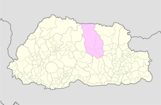
Bumthang District is one of the 20 dzongkhag (districts) comprising Bhutan. It is the most historic dzongkhag if the number of ancient temples and sacred sites is counted. Bumthang consists of the four mountain valleys of Ura, Chumey, Tang and Choekhor ("Bumthang"), although occasionally the entire district is referred to as Bumthang Valley.

Mongar District is one of the 20 dzongkhags (districts) comprising Bhutan. Mongar is the fastest-developing dzongkhag in eastern Bhutan. A regional hospital has been constructed and the region is bustling with many economic activities. Mongar is noted for its lemon grass, a plant that can be used to produce an essential oil. It also has a hydroelectric power-plant on the Kuri Chhu river.
Articles related to Bhutan include:
Mangde Chhu or Tongsa river flows in central Bhutan traversing roughly north-south. The river rises in Wangdue Phodrang district, near Gangkhar Puensum, Bhutan's highest peak at 7,546 metres (24,757 ft). Bhutan's main east-west highway crosses the Mangde Chhu about 8 kilometres (5 mi) west of Trongsa. South of Trongsa, the river drains the eastern slopes of the Black Mountains (Bhutan), and forms the eastern boundaries of Black Mountain National Park and Royal Manas National Park. Another highway follows the river south from Trongsa to Shemgang. The highway leaves the river at Tingtinbi, and eventually reaches the Indian border at Gelegphug. South of Tingtinbi, the Mangde is joined by the Bumthang River from the east, and is known as the Tongasa. Shortly before entering India in Assam, the Manas River flows into the river from the east, and the river exits Bhutan near Manas.
Trashigang, or Tashigang, is a town in eastern Bhutan and the district capital of the Trashigang Dzongkhag (district).

Bumthang Valley is the main inhabited valley in the Bumthang district of Bhutan.

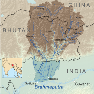
The Manas River is a transboundary river in the Himalayan foothills between southern Bhutan and India. It is named after Manasa, the serpent god in Hindu mythology. It is the largest river system of Bhutan, among its four major river systems; the other three are Amo Chu or Torsa river, Wong Chu or Raidak, Puna Tshang Chu or Sankosh. It is met by three other major streams before it again debouches into India in western Assam. The total length of the river is 400 kilometres (250 mi), flows through Tibet, China for 24 km (15 mi), flows in Bhutan for 272 kilometres (169 mi) and then flows through Assam for 104 kilometres (65 mi) before it joins the mighty Brahmaputra River at Jogighopa. Another major tributary of the Manas, the Aie River joins it in Assam at Bangpari.

The Raidāk River, also called Wang Chhu or Wong Chhu in Bhutan, is a tributary of the River Brahmaputra, and a trans-boundary river. It flows through Bhutan, India and Bangladesh.
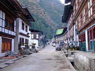
Zugne is a village in Bumthang District in central Bhutan, located south of Jakar and east of Gyetsa on the Chume River in the Chume Valley. The village is noted for its weavers with scarves tied to their heads in the Bumthang style. They weave woolen yatras on pedal looms and also make belts. It has two notable workshops along the main road, the Thogmela and the Khampa Gonpo which make brightly colored textiles.

The Kuri Chhu, also known as the Lhozhag Xung Qu or Norbu Lag Qu, is a major river of eastern Bhutan, that has formed a scenic valley with high peaks and steep hills. Kuri Chhu is a tributary of the Manas River system, which is the largest river of Bhutan and a major tributary of the Brahmaputra River that drains most of eastern Bhutan.

The Paro Chhu is a river of western Bhutan. It is a tributary of the Wong Chhu, which is known as the Raidak in its lower reaches.
The Tang Chuu is a tributary of the Mo Chhu in western Bhutan.

This is a list of the extreme points of Bhutan.

Wangchuck Centennial National Park in northern Bhutan is the kingdom's largest national park, spanning 4,914 square kilometres (1,897 sq mi) over five districts, occupying significant portions of northern Bumthang, Lhuntse, and Wangdue Phodrang Districts. It borders Tibet to the north and is bound by tributaries of the Wong Chhu (Raidāk) basin to the west. Wangchuck Centennial directly abuts Jigme Dorji National Park, Bumdeling Wildlife Sanctuary, and Phrumsengla National Park in northern Bhutan, and is further connected to Jigme Singye Wangchuck National Park in central Bhutan via biological corridors. Thus, most of northern Bhutan is part of these protected areas.
The glaciers of Bhutan, which covered about 10 percent of the total surface area in the 1980s, are an important renewable source of water for Bhutan's rivers. Fed by fresh snow each winter and slow melting in the summer, the glaciers bring millions of litres of fresh water to Bhutan and downriver areas each year. Glacial melt also adds to monsoon-swollen rivers which may be a contributing factor to flooding. Where glacial movement temporary blocks riverflows, downstream areas may be threatened by glacial lake outburst flood ("GLOFs"). Although GLOFs are not a new phenomenon in Bhutan, their frequency has risen in the past three decades. Significant GLOFs occurred in 1957, 1960, 1968 and 1994, devastating lives and property downstream. According to the Bhutan Department of Energy however, the majority of rivers in Bhutan are more susceptible to fluctuation with changing rainfall patterns than to flooding directly attributable to glacier or snow melt.

The valleys of Bhutan are carved into the Himalaya by Bhutan's rivers, fed by glacial melt and monsoon rains. As Bhutan is landlocked in the mountainous eastern Himalaya, much of its population is concentrated in valleys and lowlands, separated by rugged southward spurs of the Inner Himalaya. Despite modernization and development of transport in Bhutan, including a national highway system, travel from one valley to the next remains difficult. Western valleys are bound to the east by the Black Mountains in central Bhutan, which form a watershed between two major river systems, the Mo Chhu and the Drangme Chhu. Central valleys are separated from the east by the Donga Range. The more isolated mountain valleys protect several tiny, distinct cultural and linguistic groups. Reflecting this isolation, most valleys have their own local protector deities.
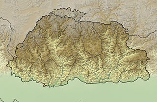
The mountains of Bhutan are some of the most prominent natural geographic features of the kingdom. Located on the southern end of the Eastern Himalaya, Bhutan has one of the most rugged mountain terrains in the world, whose elevations range from 160 metres (520 ft) to more than 7,000 metres (23,000 ft) above sea level, in some cases within distances of less than 100 kilometres (62 mi) of each other. Bhutan's highest peak, at 7,570 metres (24,840 ft) above sea level, is north-central Gangkhar Puensum, close to the border with China; the third highest peak, Jomolhari, overlooking the Chumbi Valley in the west, is 7,314 metres (23,996 ft) above sea level; nineteen other peaks exceed 7,000 metres (23,000 ft). Weather is extreme in the mountains: the high peaks have perpetual snow, and the lesser mountains and hewn gorges have high winds all year round, making them barren brown wind tunnels in summer, and frozen wastelands in winter. The blizzards generated in the north each winter often drift southward into the central highlands.
| Authority control |
|
|---|
Coordinates: 27°01′07″N90°50′25″E / 27.0187°N 90.8404°E