Hooghly River

Last updated

Hooghly River
Bhagirathi
HooghlyRiverOverBally gobeirne.jpg
The River Hooghly flowing through Bally , Howrah
Location
Country India
State West Bengal
DistrictsMurshidabad, Nadia, Purba Bardhaman, Hooghly, Howrah, North 24 Parganas, Kolkata, South 24 Parganas, East Midnapore
Physical characteristics
Source Ganga
Mouth Bay of Bengal
  location
Sunderbans in West Bengal
Length260 kilometres
Depth 
  maximum117 m
Basin features
Bridges Vidyasagar Setu (Second Hooghly Bridge)
Rabindra Setu (Howrah Bridge)
Nivedita Setu
Vivekananda Setu (Bally bridge)
Sampreeti Bridge
Jubilee Bridge
Ishwar Gupta Setu
Gourango Setu
New Bhagirathi Bridge
Ramendra Sundar Tribedi Setu
Jangipur Bhagirathi Bridge

The Hooghly River (Anglicized alternatively spelt as Hoogli or Hugli) or popularly called Ganga [1] or Kati-Ganga in the Puranas, is a river that rises close to Giria, which lies north of Baharampur and Palashi in Murshidabad. It is the western distributary of the Ganges. [2] The main course of the Ganges then flows into Bangladesh as the Padma. [3] A man-made canal, built in the 1960s and early-1970s at Farakka, connects the Ganges, flowing through Malda, to the Hooghly (also called Bhagirathi) to bring the abundant waters of the Himalayan river to the comparatively narrow river that rises in eastern West Bengal.

Contents

The river flows through the Rarh region, comprising the lower deltaic districts of West Bengal, to meet the Bay of Bengal. The upper riparian zone of the river is called the Bhagirathi while the lower riparian zone is called the Hooghly. Major and minor rivers that drain into the Hooghly include the Ajay, Falgu, Jalangi and Churni to the north and Rupnarayan, Mayurakshi, Damodar and Haldi to the south. Major cities that stand on the banks of the Hooghly are Baharampur, Kalyani, Tribeni, Saptagram, Bandel, Hugli, Chandannagar, Srirampur, Barrackpur, Rishra, Konnagar, Uttarpara, Titagarh, Kamarhati, Agarpara, Baranagar, Howrah, Kolkata, and Uluberia. [4]

The Hooghly has religious significance as Hindus consider the river sacred. The river also plays a major role in the agriculture, industry, and climate of the state.

Course

The vast majority of the water that flows into the Hooghly River is provided by the man-made Farakka Feeder Canal, rather than the natural source of the river at Giria. The Farakka Barrage is a dam that diverts water from the Ganges into the Farakka Feeder Canal near the town of Tildanga in Murshidabad district, located 40 km upstream from Giria. This supplies the Hooghly with water as per the agreement between India and Bangladesh. The feeder canal runs parallel to the Ganges, past Dhulian, until just above Jahangirpur where the canal ends and joins the Bhagirathi river. The Bhagirathi then flows south past Jiaganj Azimganj, Murshidabad and Baharampur.

Bhagirathi River, Murshidabad Bhagirathi River.jpg
Bhagirathi River, Murshidabad

South of Baharampur and north of Palashi it used to form the border between Bardhaman District and Nadia District, but while the border has remained the same the river is now often east or west of its former bed. The river then flows south past Katwa, Nabadwip, Kalna and Jirat. At Kalna it originally formed the border between Nadia District and Hooghly District, and then further south between Hooghly District and North 24 Parganas District. It flows past Halisahar, Chinsurah, Naihati, Bhatpara, Konnagar, Serampore, and Kamarhati. Then, just before entering the twin cities of Kolkata (Calcutta) and Howrah, it turns to the southwest. At Nurpur it enters an old channel of the Ganges, and turns south to empty into the Bay of Bengal through an estuary about 20 mi (32 km) wide. [5]

Ain-i-Akbari, [6] a book by Abu'l-Fazl, describes that the river Ganga and river Sarwasati (Sarsuti) streams of lower Bengal had different flows. According to the footnotes of this book, the colour of the water of the Sarawasati was white, the colour of another stream named Jamuna was blue, and the colour of the Ganga was muddy and yellowish. From Kolkata the main flow of the Hooghly-Bhagirathi (or Ganga) used to run along the side of the Kalighat temple, Baruipur, Jaynagar Majilpur, Chhatrabhog and Hatiagarh. At that time, between Khiderpore and Sankrail [7] no flow existed. Presently, the stream between Khiderpore and Sankrail became known as KatiGanga. A channel had been dug at the time of Alibardi Khan in the middle of the 18th century. This happened with the assistance of Dutch traders, who also set up a toll point on the Hooghly river. [8] So the present reach of the Hooghly is the lower part of the historical Saraswati. Kolkata the capital of West Bengal is located on the banks of the Hoogly river.

Map of the Hooghly River delta showing Sagar Island Hooghly.jpg
Map of the Hooghly River delta showing Sagar Island

Tidal bore

Hooghly River, Serampore Hooghly River @ Serampore.jpg
Hooghly River, Serampore

The tide runs rapidly on the Hooghly, and produces a remarkable example of the fluvial phenomenon known as a tidal bore. This consists of the head-wave of the advancing tide, hemmed in where the estuary narrows suddenly into the river, and often exceeds 7 ft (2.1 m) in height. It is felt as high up as Naihati 35 km upstream of Calcutta, and frequently destroys small boats. [9] A tidal bore which overcame the banks of the river in 1876 was reported to have killed up to a hundred thousand people. [9] The difference from the lowest point of low-water in the dry season to the highest point of high-water in the rains is reported to be 20 ft 10 in (6.35 m). The greatest mean rise of tide, about 16 ft (4.9 m), takes place in March, April or May - with a declining range during the rainy season to a mean of 10 ft (3.0 m), and a minimum during freshets of 3 ft 6 in (1.07 m).

History

In its upper reaches the river is generally known as the Bhāgirathi, until it reaches Hooghly. The word Bhāgirathi literally means "caused by Bhagiratha", a Hindu mythological Solar dynasty prince who was instrumental in bringing the river Ganges from heaven to the earth, in order to release his 60,000 grand-uncles from a curse of the saint Kapila. [10]

In 1974, the Farakka Barrage began diverting water into the Hooghly during the dry season so as to reduce the silting difficulties at Kolkata's port.

Like the rest of the Ganges, the Bhāgirathi-Hooghly is considered sacred to Hindus, [11] and its water is considered holy.

Bridges and tunnels

Sunset at River Hooghly, Kolkata, West Bengal, India Sunset at Hooghly.jpg
Sunset at River Hooghly, Kolkata, West Bengal, India

The following bridges currently span the Hooghly/Bhagirathi River; listed from south to north (mouth to source), until the Farakka Feeder Canal meets the river:

The following bridges are under various stages of development:

The following tunnels are situated under the Hooghly River :-

Hooghly River Underwater metro tunnel segment Hooghly river underwater metro tunnel as seen in Narendra Modi's video (cropped).jpg
Hooghly River Underwater metro tunnel segment

Economics

A ferry operating between Howrah and Kolkata with Howrah Bridge (Rabindra Setu) in background Ferry Howrah Bridge.jpg
A ferry operating between Howrah and Kolkata with Howrah Bridge (Rabindra Setu) in background

The Bhāgirathi-Hooghly river system is an essential lifeline for the people of West Bengal. It was through this river that the East India company sailed into Bengal and established their trade settlement, Calcutta, the capital of British India. People from other countries such as the French, Dutch, Portuguese, etc. all had their trade settlements by the banks of this river.

The river provides a perennial supply of water to the plain of West Bengal for irrigation and human & industry consumption. The river is navigable and a major transport system in the region with a large traffic flow. For a long time, the Calcutta Port was the biggest port of India. Although in the past its significance had gone down, recently it has reached the 3rd position in the list of Indian Ports. The modern container port of Haldia, on the intersection of lower Hooghly and Haldi River, now carries much of the region's maritime trade. One new port will be built in the deep sea to reduce the load on Calcutta port.

Despite the river being polluted, the fish from it are important to the local economy.

Panoramic view of Kolkata from Howrah with Second Hooghly Bridge Howrah Pano 4.jpg
Panoramic view of Kolkata from Howrah with Second Hooghly Bridge

The Hooghly river valley was the most important industrial area of the state of Bengal. Despite a decline of the jute industry, the prime industry of this region, it is still one of the biggest industrial areas of India. It has a number of small cities which form the Greater Kolkata agglomeration, the second biggest Indian city and the former capital.

In September 2015, the Government of West Bengal announced that renovation of the Hooghly riverfront in Kolkata will be completed with the help of World Bank funding under the National Ganga River Basin Project Scheme. [14]

Hooghly River in arts

Ganga Arati on the banks of the Hooghly river, Howrah Howrah Arati 1.jpg
Ganga Arati on the banks of the Hooghly river, Howrah
The Hooghly River from the Harvest Fields of Bengal, c. 1905 From the Harvest Fields of Bengal.jpg
The Hooghly River from the Harvest Fields of Bengal, c. 1905
Hooghly River near Diamond Harbour Diamond Harbour on the Bank of Hoogly.jpg
Hooghly River near Diamond Harbour

Literature

Rudyard Kipling wrote an article, On the Banks of the Hugli (1888), [15] and a short story set on the Hooghli, An Unqualified Pilot (1895). [16]

Cultural events

The Silk River project aims at exploring the artistic relationship between Kolkata and London through artistic exchange from 10 locations each along the Hooghly River and the River Thames. The 10 places along the Hooghly River are Murshidabad, Krishnagar, Chandernagore, Barrackpore, Jorasanko, Bowbazar, Howrah, Kidderpore, Botanical Gardens and Batanagar. Ten scrolls, painted in the Patua tradition, depicting the 10 places will be carried along the Hooghly River. The event began at Murshidabad on 7 December 2017 and ended at the Victoria Memorial, Kolkata on 17 December. [17] [18]

Hooghly River, Calcutta by Francis Frith (taken 1850s-1870s) Hooghly River, Calcutta by Francis Frith (3).jpg
Hooghly River, Calcutta by Francis Frith (taken 1850s-1870s)

See also

Related Research Articles

<span class="mw-page-title-main">Howrah</span> Metropolis in West Bengal

Howrah is a district in the Indian state of West Bengal. Howrah District is located on the western bank of the Hooghly River. Howrah city is the head quarters of Howrah district. Large part of Howrah district is an important suburb of city of Kolkata. It is also part of the Kolkata Metropolitan Area, with development from the Kolkata Metropolitan Development Authority. It is the transportation hub and gateway to Kolkata’s oldest CBD ( Dalhousie) and West Bengal via Howrah railway station, Santragachi Railway Terminal and Howrah Bridge.

<span class="mw-page-title-main">Padma River</span> Major river in Bangladesh

The Padma is a major river in Bangladesh. It is the main distributary of the Ganges, flowing generally southeast for 356 kilometres (221 mi) to its confluence with the Meghna River near the Bay of Bengal. The city of Rajshahi is situated on the banks of the river. Since 1966, over 66,000 hectares of land has been lost to erosion of the Padma.

<span class="mw-page-title-main">Vivekananda Setu</span> Steel multi-span road cum railway bridge in West Bengal, India

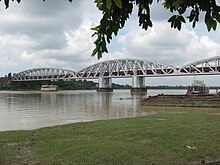
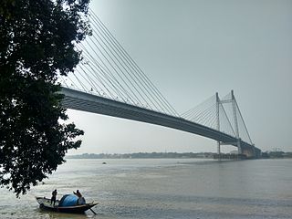
Vivekananda Setu is a bridge over the Hooghly River in West Bengal, India. It links the city of Howrah, at Bally, to Kolkata, at Dakshineswar. Completed on 1931, it is a multispan truss bridge and was built to primarily to provide direct road and rail connectivity between the Calcutta Port and the major railhead at Howrah railway station on the West bank of the Hooghly River. It is 2,887 feet (880 m) long having 9 spans in total. The famous Dakshineswar Kali Temple is situated on the banks of the Hooghly River near the bridge. The bridge is one of the four bridges linking Howrah and Kolkata. A new road bridge, the Nivedita Setu, was constructed 50 m (160 ft) downstream in 2007 due to weakening of the Vivekanada Setu caused by its ageing.

<span class="mw-page-title-main">Hugli-Chuchura</span> City in West Bengal, India

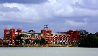
Hugli-Chuchura, also known by its former names Chinsurah or Hooghly-Chinsurah, is a city of Hooghly district and the district headquarters of Hooghly division in the Indian state of West Bengal. It is one of the densely populated cities of West Bengal. It lies on the bank of Hooghly River, 35 km north of Kolkata, the state capital. It is located in the district of Hooghly and is home to the district headquarters. Chuchura houses the Commissioner of the Burdwan Range. The District Court building of Chinsurah is the longest building in West Bengal. It is a part of Greater Kolkata covered by Kolkata Metropolitan Development Authority (KMDA).

<span class="mw-page-title-main">Jangipur, Murshidabad</span> City in West Bengal, India

Jangipur is a city and a municipality in Murshidabad district in the state of West Bengal, India. It is the headquarters of the Jangipur subdivision. It is situated on the banks of the Bhagirathi. Jangipur is an old town having reference from the historical period of Moghul emperor Jahangir when an army camp was established here.

<span class="mw-page-title-main">Geography of West Bengal</span> Overview of the geography of the Indian state

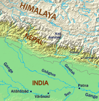
The Geography of West Bengal, a state in eastern India, is primarily defined by plains and plateaus, with the high peaks of the Himalayas in the north and the Bay of Bengal to the south.

<span class="mw-page-title-main">Bansberia</span> City in West Bengal, India

Bansberia is a city and a municipality of Hooghly district in the Indian state of West Bengal. It is about 45 km (28 mi) away from Kolkata, at the western end of the Iswar Gupta Setu (Kalyani-Bansberia) Bridge. It is a part of the area covered by Kolkata Metropolitan Development Authority (KMDA). Bans Beria railway station is 4 km from Bandel Junction on the Bandel-Katwa Line.The area covered by two police stations - Chinsurah (W.no.1-4) and Mogra (W.no.5-22). The part of both Police Stations governed by Chandannagar Police Commissionerate. Very good and innocent people live here so, The criminal reports are very few in this city. It is the "Peaceful City" of Hooghly District. Kartik Puja is the famous festival of Bansberia.

<span class="mw-page-title-main">Dhuliyan</span> Town in West Bengal, India

Dhuliyan is a municipality town in the Samserganj block of Jangipur subdivision of Murshidabad district in the state of West Bengal, India. This municipality was established in the year 1909 and comprises 21 wards. It is located between the Ganges and the Feeder canal.

<span class="mw-page-title-main">Farakka Barrage</span> Dam in West Bengal, India

Farakka Barrage is a barrage across the Ganga river located in Murshidabad district in the Indian state of West Bengal, roughly 18 kilometres (11 mi) from the border with Bangladesh near Shibganj. Farakka Barrage Township is located in Farakka in Murshidabad district. Construction of the barrage started in 1962, and was completed in 1970 at a cost of $208 million. It became operational on 21 April 1975. The barrage is about 2,304 metres (7,559 ft) long. The Feeder Canal (Farakka) from the barrage to the Bhagirathi-Hooghly River is about 42 km (26 mi) long.

<span class="mw-page-title-main">Murshidabad district</span> District in West Bengal, India

Murshidabad district is a district in the Indian state of West Bengal. Situated on the left bank of the river Ganges, the district is very fertile. Covering an area of 5,341 km2 (2,062 sq mi) and having a population 7.103 million, it is a densely populated district and the ninth most populous in India. Berhampore city is the headquarters of the district.

<span class="mw-page-title-main">Tribeni, Hooghly</span> Neighbourhood in Hooghly, West Bengal, India

Tribeni is a locality in Bansberia Municipality of Hooghly district in the Indian state of West Bengal and is currently a part of the area covered by (KMDA). It is an old holy place for the Hindus, the sanctity of which has been recognized for many centuries and had been mentioned in Pavanaduta, a Sanskrit piece of the last quarter of the 12th century. The Muslims took it over during early phases of their conquest of Bengal, also referred to as Turkish conquest in the thirteenth century. The place retains its holiness for multiple centuries, primarily due to the rivers it hosted, corroborated by records of the bathers at different timelines, who thronged during the festival of Makar Sankranti. Of the many odes written on the Ganges in various Indian languages.

<span class="mw-page-title-main">Jalangi River</span> River in West Bengal, India

Jalangi River, is a branch of the Ganges river in Murshidabad and Nadia districts in the Indian state of West Bengal. It flows into the Bhagirathi river and strengthens its lower channel, the Hooghly.

<span class="mw-page-title-main">Ganges water dispute</span>

A long-standing dispute exists between India and Bangladesh over the appropriate allocation, and development, of the water resources of the Ganges River, which flows from northern India into Bangladesh. The issue had remained a subject of conflict for almost 35 years, with several bilateral agreements and rounds of talks failing to produce results.

<span class="mw-page-title-main">Vidyasagar Setu</span> Cable-stayed toll bridge in West Bengal, India

Vidyasagar Setu, also known as the Second Hooghly Bridge, is a toll bridge over the Hooghly River in West Bengal, India, linking the cities of Kolkata and Howrah.

<span class="mw-page-title-main">Farakka (community development block)</span> Community development block in West Bengal, India

Farakka is a community development block that forms an administrative division in the Jangipur subdivision of Murshidabad district in the Indian state of West Bengal.

<span class="mw-page-title-main">Barharwa–Azimganj–Katwa loop</span> Railway line connecting Barharwa and Katwa, West Bengal

The Barharwa–Azimganj–Katwa loop is a railway line connecting Barharwa on the Sahibganj loop and Katwa. Together with the Bandel–Katwa line, which connects this line to Bandel Junction on the Howrah–Bardhaman main line, it is also known as the B.B Loop Line. This 170 kilometres (110 mi) line is under the jurisdiction of Eastern Railway. The majority of this line passes through the Purba Bardhaman and Murshidabad districts, in the Indian state of West Bengal, and lies on the west bank of the Bhagirathi river.

<span class="mw-page-title-main">National Highway 12 (India)</span> National highway in India

National Highway 12, previously NH 34, is a National Highway in India which runs entirely in West Bengal. It runs from its junction with NH 27 at Dalkhola terminating at Bakkhali.

<span class="mw-page-title-main">Farakka Feeder Canal</span> The canal associated with the Farakka Barrage

Feeder Canal is a canal associated with Farakka Barrage. It is located in Murshidabad district, West Bengal. The canal is 38.3 km long. The Ganges water from the Farakka Dam is being conveyed to Bhagirathi by way of this canal. Due to the flow of river Hooghly through the Farakka dam project, around 40,000 ft³/s of water is available daily in the Feeder connection. The Feeder canal has been designed keeping in mind the ability to carry this amount of water. However, during the dry season, less water is released. The dry season is from January to May. During the period the flow of water in the feeder canal is reduced from ca. 40,000 ft³/s to 30,000-28,000 ft³/s. If the severe drought brings down the Ganges water from its upper reaches, then less water is available in feeder canal.

River bank erosion along the Ganges in Malda and Murshidabad districts focusses on river bank erosion along the main channel of the Ganges in Malda and Mushidabad districts of West Bengal, India.

<span class="mw-page-title-main">Khagraghat Road railway station</span>

Khagraghat Road is a railway station on the Barharwa–Azimganj–Katwa loop in Baharampur city and is located in Murshidabad district in the Indian state of West Bengal. Khagraghat Road serves westside of Baharampur.

References

  1. The river is locally called Ganga because it is one of the two distributaries of the Ganges and is hence considered to be sacred. The Puranas call this arm of the Ganges, the Ganges itself. Some more modern sources, relying entirely on the scriptures, suggest that this river is the Ganga itself, 'Hoogly' being just a regional nickname. However, there is no scientific basis of this claim. 1, 2
  2. The Editors of Encyclopedia Britannica (5 August 2010). "Bhagirathi River". Britannica. Retrieved 3 June 2023.
  3. Allison, Mead A. (Summer 1998). "Geologic Framework and Environmental Status of the Ganges-Brahmaputra Delta". Journal of Coastal Research. 13 (3). Coastal Education & Research Foundation, Inc.: 826–836. JSTOR   4298836.
  4. "District". Voiceofbengal.com. Archived from the original on 11 November 2014. Retrieved 10 May 2012.
  5. "Hugli River". Encyclopædia Britannica. Archived from the original on 5 June 2016. Retrieved 8 July 2016.
  6. https://archive.org/details/ainiakbarivolum00mubgoog The Ain I Akbary Abul Fazl Allammi Vol-2, Translated by Colonel H.S.Jarrett published by The Asiatic Society of Bengal Printed at the Baptist Mission Press in 1891 Calcutta page-120.
  7. https://cclpworldwide.com/wp-content/uploads/2020/03/Hooghly-Jelar-Itihas-Sudhir-Kumar-Mitra.pdf Archived 23 March 2020 at the Wayback Machine Jelar Itihas Sudhir Kumar Mitra/ page no 792 (original book) internet page 806
  8. Chakraborty, Satyesh C. "The Story of River Port". Kolkata Port Trust. Archived from the original on 2011-07-21. Retrieved 2007-12-10.
  9. 1 2 Helen Schreider; Frank Schreider (October 1960). "From The Hair Of Siva". National Geographic . 118 (4): 445–503.
  10. Narayan, R. K. (29 August 2006). The Ramayana: A Shortened Modern Prose Version of the Indian Epic. Penguin. p. 31. ISBN   978-1-4406-2327-1.
  11. "What is the origin of holy river Ganga?". 20 March 2020. Archived from the original on 23 March 2020. Retrieved 23 March 2020.
  12. 1 2 "Three river bridges in WB to boost trade, highlight culture". The Indian Express. 6 October 2017. Archived from the original on 12 March 2018. Retrieved 12 March 2018.
  13. "Kolkata Metro: 87 years on, boring re-creates CESC feat". The Times of India. 18 April 2017. Archived from the original on 22 September 2022. Retrieved 29 September 2022.
  14. "World Bank to fund Hooghly riverfront revamp - Times of India". The Times of India . 3 September 2015. Archived from the original on 7 September 2015. Retrieved 3 September 2015.
  15. "Chapter IV - City of Dreadful Night - From Sea to Sea - Rudyard Kipling, Book, etext". Telelib.com. 1 February 2003. Archived from the original on 3 March 2016. Retrieved 25 August 2013.
  16. "An Unqualified Pilot - Land & Sea Tales - For Scouts and Guides - Rudyard Kipling, Book, etext". Telelib.com. 1 March 2003. Archived from the original on 5 April 2016. Retrieved 25 August 2013.
  17. Chatterjee, Chandreyee (10 November 2016). "Exploring the River Connect". No. Kolkata. ABP. The Telegraph. Archived from the original on 15 January 2018. Retrieved 21 July 2017.
  18. Basu, Anasuya (21 July 2017). "River Walk to Boost Ties". No. Kolkata. ABP. The Telegraph. Archived from the original on 15 January 2018. Retrieved 21 July 2017.

21°55′N88°05′E / 21.917°N 88.083°E / 21.917; 88.083