Bangladesh is a densely populated, low-lying, mainly riverine country located in South Asia with a coastline of 580 km (360 mi) on the northern littoral of the Bay of Bengal. The delta plain of the Ganges (Padma), Brahmaputra (Jamuna), and Meghna Rivers and their tributaries occupy 79 percent of the country. Four uplifted blocks occupy 9 percent and steep hill ranges up to approximately 1,000 metres (3,300 ft) high occupy 12 percent in the southeast and in the northeast. Straddling the Tropic of Cancer, Bangladesh has a tropical monsoon climate characterised by heavy seasonal rainfall, high temperatures, and high humidity. Natural disasters such as floods and cyclones accompanied by storm surges periodically affect the country. Most of the country is intensively farmed, with rice the main crop, grown in three seasons. Rapid urbanisation is taking place with associated industrial and commercial development. Exports of garments and shrimp plus remittances from Bangladeshis working abroad provide the country's three main sources of foreign exchange income.

The Brahmaputra is a trans-boundary river which flows through Southwestern China, Northeastern India, and Bangladesh. It is known as Brahmaputra or Luit in Assamese, Yarlung Tsangpo in Tibetan, the Siang/Dihang River in Arunachali, and Jamuna River in Bengali. By itself, it is the 9th largest river in the world by discharge, and the 15th longest.
Gaibandha is a district in northern Bangladesh, located within the Rangpur Division. Covering an area of 2,179.27 square kilometers, it had a population of 2,562,232 as of the 2022 census. The district's administrative headquarters and largest urban center is Gaibandha town. Originally established as a subdivision in 1875 under the name Bhabanigonj, it was renamed Gaibandha in the same year. On February 15, 1984, Gaibandha was officially upgraded to district status. The district is known for its agricultural production, particularly rice, jute, and vegetables, and is situated at the confluence of several major rivers, including the Jamuna, Teesta, and Brahmaputra.

Bangaon is a city and a municipality in North 24 Parganas district in the state of West Bengal, India. It is the headquarters of the Bangaon subdivision.

The Jaldhaka River (Pron:/ˌdʒælˈdɑːkə/), also known as Dichu, is a tributary of the Brahmaputra and a trans-boundary river flowing through India, Bhutan and Bangladesh with a length of 233 kilometres. It originates from the Bitang Lake at Kupup, Gangtok District, Sikkim, near the Jelep La pass below Dongkya Mountain Range. It flows through Pakyong District of Sikkim, India and then passes through forests of Samtse District of Bhutan where it flows for around 40 kilometres and than re-enters India at Bindu, Kalimpong district. Further it passes through Neora Valley National Park, Chapramari Wildlife Sanctuary and Gorumara National Park in West Bengal along with cities and towns, like Paren, Gairibas, Jhalong, Dhupguri, Falakata, Mathabhanga and flows through Kalimpong, Jalpaiguri and Cooch Behar districts in West Bengal, India before entering Bangladesh at Mogolhat, Lalmonirhat District of Rangpur Division. It is known as Dharla River in Bangladesh and flows through towns like Kolaghat, Phulbari and Kurigram City and Passes southwards until the Dharla debouches into the Brahmaputra River at Bagua Anantpur of Kurigram District. Due to the river's wandering over several international borders, only a small length of the river lies in Bangladesh and Bhutan and most of its path lies in India. In some places, this river is also known as Mansai river and Singhimari river.

Kainakary is a village in Kuttanad Taluk in Alappuzha District of the Indian state of Kerala.
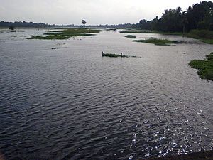
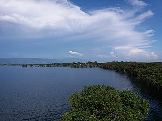
Bangladesh, being situated on the Brahmaputra River Delta is a land of many rivers, and as a result is very prone to flooding. Due to being part of such a basin and being less than 5 meters above mean sea level, Bangladesh faces the cumulative effects of floods due to water flashing from nearby hills, the accumulation of the inflow of water from upstream catchments, and locally heavy rainfall enhanced by drainage congestion. Bangladesh faces this problem almost every year. Coastal flooding, combined with the bursting of river banks is common, and severely affects the landscape and society of Bangladesh. 80% of Bangladesh is floodplain, and it has an extensive sea coastline, rendering the nation very much at risk of periodic widespread damage. Whilst more permanent defenses, strengthened with reinforced concrete, are being built, many embankments are composed purely of soil and turf and made by local farmers. Flooding normally occurs during the monsoon season from June to September. The convectional rainfall of the monsoon is added to by relief rainfall caused by the Himalayas. Meltwater from the Himalayas is also a significant input.

Rajanpur is a district of Dera Ghazi Khan Division in the Pakistani province of Punjab, with its administrative headquarters the city of Rajanpur. District of Rajanpur was formerly part of Dera Ghazi Khan District and was created on 1 July 1982. According to the 2023 Pakistani census, the district had a population of 2,323,980.

Uttar Pradesh is India's fourth largest state by land area, and most populous state, located in the north-central part of the country. It spreads over a large area, and the plains of the state are quite distinctly different from the high mountains in the north. The climate of this state can also vary widely - primarily due to it being far from the moderating effect of the sea and the occasional cold air arising due to western disturbances.it has been seen that in uttar pradesh there is very hot climate wright now

Madarganj is an Upazila in Jamalpur District, in the Division of Mymensingh, Bangladesh.The area is known for its rich cultural heritage, natural beauty, and agricultural productivity.

Daulatpur is an upazila of Manikganj District in the Division of Dhaka, Bangladesh.

The Dharla River is a tributary of the Brahmaputra which is a trans-boundary river flowing through India, Bhutan and Bangladesh. It originates from Kupup/Bitang lake lying in Pangolakha Wildlife Sanctuary of East Sikkim in the Himalayas where it is known as the Jaldhaka River. It then flows through East Sikkim, India then goes to Samtse District, Bhutan and returns to India again at Kalimpong district. From there, it flows through Jalpaiguri and Cooch Behar districts of West Bengal, India, one of the seven main rivers to do so. Here the river enters Bangladesh through the Lalmonirhat District and flows as the Dharla River until it empties into the Brahmaputra River near the Kurigram District. Near Patgram Upazila, it again flows easterly back into India. It then moves south and enters Bangladesh again through Phulbari Upazila of Kurigram District and continues a slow meandering course.
The Bangali River is one of the main rivers in northern Bangladesh. As of 2007, the river is in the news because of the possibility that it might merge with the Jamuna River, which could lead to major changes in the geography of the region.

Gaighata is a community development block that forms an administrative division in Bangaon subdivision of North 24 Parganas district in the Indian state of West Bengal.
A haor is a wetland ecosystem in the north eastern part of Bangladesh which physically is a bowl or saucer shaped shallow depression, also known as a backswamp. During monsoons haors receive surface runoff water from rivers and canals to become vast stretches of turbulent water.

Ganges is a nature documentary series for television on the natural history of the River Ganges in India and Bangladesh. It showcases the variety of animals and habitats that are to be found along the river's 2,510 km (1,557 mi) reach, as well as the cultures, traditions and religions of the large human population that it supports. For Hindus, the Ganges is a sacred river and a place of pilgrimage, and it holds a deep influence on their religion and culture as well as being their lifeblood. Over the course of three episodes, the series is presented as a journey from the source of the river in the high Himalaya to its delta at the Bay of Bengal.
Barun Biswas was a Bengali school teacher and a social activist in Sutia, West Bengal, India. In 2000, he co-founded "Sutia Gonodhorshon Pratibad Mancha", an organisation which protested against a local criminal gang, who were using gang-rape to terrorise the people of Sutia. Biswas was murdered on 5 July 2012. In 2013, a Bengali film Proloy was made, based on his life and fight.

Kharua Rajapur is a village in Kalupur gram panchayat in Bangaon CD Block in Bangaon subdivision of North 24 Parganas district in the Indian state of West Bengal.
2000 India–Bangladesh floods, also known as the flood of 2000 occurred in the districts of West Bengal, India and the India-Bangladesh border districts of Khulna Division in 2000. In the sudden flood, people left their houses and took shelter in refuge camps.

Beginning in May 2022, deadly floods hit northeastern India and Bangladesh. Over 9 million people in both countries have been affected, and around 300 people were killed.