This article relies largely or entirely on a single source .(June 2024) |
| Shilabati River | |
|---|---|
 Sunset on the Shilabati in December | |
 | |
| Location | |
| Country | India |
| State | West Bengal |
| City | Purulia |
| Physical characteristics | |
| Source | |
| • location | Near Chak Gopalpur, Hura Block, Purulia District |
| • coordinates | 23°14′11″N86°38′41″E / 23.2363°N 86.6448°E |
| Mouth | |
• location | Rupnarayan River |
• coordinates | 22°40′17″N87°46′41″E / 22.6714°N 87.7781°E |
| Basin features | |
| Tributaries | |
| • left | Jaipanda River near Amlasuli |
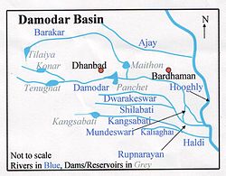
Shilabati River (also known as Shilai) originates near Chak Gopalpur village of Hura block in the Purulia district of the Indian state of West Bengal. [1] It flows in an almost southeasterly direction through the districts of Bankura and Paschim Medinipur. The Shilabati joins the Dwarakeswar from the right near Ghatal and afterwards is known as Rupnarayan. It finally joins the Hooghly River, which empties into the Bay of Bengal. [2]

