Related Research Articles

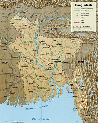
Bangladesh is a densely populated, low-lying, mainly riverine country located in South Asia with a coastline of 580 km (360 mi) on the northern littoral of the Bay of Bengal. The delta plain of the Ganges (Padma), Brahmaputra (Jamuna), and Meghna Rivers and their tributaries occupy 79 percent of the country. Four uplifted blocks occupy 9 percent and steep hill ranges up to approximately 1,000 metres (3,300 ft) high occupy 12 percent in the southeast and in the northeast. Straddling the Tropic of Cancer, Bangladesh has a tropical monsoon climate characterised by heavy seasonal rainfall, high temperatures, and high humidity. Natural disasters such as floods and cyclones accompanied by storm surges periodically affect the country. Most of the country is intensively farmed, with rice the main crop, grown in three seasons. Rapid urbanisation is taking place with associated industrial and commercial development. Exports of garments and shrimp plus remittances from Bangladeshis working abroad provide the country's three main sources of foreign exchange income.

The Arctic Archipelago, also known as the Canadian Arctic Archipelago, is an archipelago lying to the north of the Canadian continental mainland, excluding Greenland and Iceland.
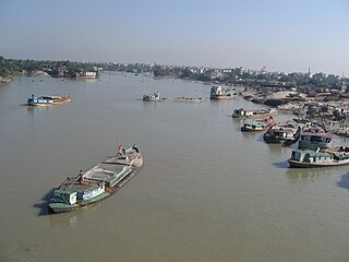
The Meghna is one of the major rivers in Bangladesh, one of the three that form the Ganges Delta, the largest delta on earth, which fans out to the Bay of Bengal. A part of the Surma-Meghna River System, the Meghna is formed inside Bangladesh in Kishoreganj District above the town of Bhairab Bazar by the joining of the Surma and the Kushiyara, both of which originate in the hilly regions of eastern India as the Barak River. The Meghna meets its major tributary, the Padma, in Chandpur District. Other major tributaries of the Meghna include the Dhaleshwari, the Gumti, and the Feni. The Meghna empties into the Bay of Bengal in Bhola District via four principal mouths, named Tetulia (Ilsha), Shahbazpur, Hatia, and Bamni.
The Bura Gauranga River and sea channel are located in the Patuakhali district of Barisal Division in south-central Bangladesh.
Batak Rabit is a small town in Hilir Perak District, Perak, Malaysia. The town is located near Teluk Intan town. It was named after Batak mercenaries that comes from the Batak District in Sumatra that was brought by Raja Laut during a Selangor civil war had their ears and noses grossly bangled that hung out.

Susunia is a hill of southern West Bengal, India. It is known for its holy spring, flora and the rock faces on which many mountaineers of the region started their journey. It is also a reserve for medicinal plants. Susunia is a part of the Eastern Ghats and is situated at the north-western part of Bankura District.

Lalmohan is an upazila of Bhola District in the Division of Barisal, Bangladesh.

Tazumuddin is an upazila of Bhola District in the Division of Barisal, Bangladesh.

Lohajang is an upazila of Munshiganj District in the Division of Dhaka, Bangladesh.

Mymensingh Sadar is an upazila of Mymensingh District in the Division of Mymensingh, Bangladesh. Most of the area of this sadar upazila is now under the Mymensingh City Corporation.

Baliakandi is an Upazila of Rajbari District in the Division of Dhaka, Bangladesh.
Turag River is the upper tributary of the Buriganga, a major river in Bangladesh. The Turag originates from the Bangshi River, the latter an important tributary of the Dhaleshwari River, flows through Gazipur and joins the Buriganga at Mirpur in Dhaka District. It is navigable by boat all year round.

Shitalakshya River is a distributary of the Brahmaputra. A portion of its upper course is known as Banar River or Banor River. In the Shitalakshya's initial stages, it flows in a southwest direction and then east of the city of Narayanganj in central Bangladesh until it merges with the Dhaleswari near Kalagachhiya. The river is about 110 kilometres (68 mi) long and at it widest, near Narayanganj, it is 300 metres (980 ft) across. Its flow, measured at Demra, has reached 74 cubic metres per second (2,600 cu ft/s). It remains navigable year round. The Shitalakshya flows through Gazipur district forming its border with Narsingdi for some distance and then through Narayanganj District.

The Bangshi is an important river in central Bangladesh. It originates in Jamalpur, from the course of the old Brahmaputra and flows past the Madhupur tract. It flows through Tangail and meets the Tongi in Ghazipur. It passes near Jatiyo Smriti Soudho in Savar and falls into the Dhaleshwari. About 238 kilometres (148 mi) long, it is not navigable for most of the year except when swelled by the monsoon rains. Louhajang River is a tributary of the Bangshi. Dhamrai on the banks of the Bangshi is famous for its muslin weaving.

Louhajang River is located in central Bangladesh. It branches off from the Jamuna near Gabsain at Bhuapur, Tangail District. Thereafter it bifurcates before the two parts meet up again. It flows past Tangail city, Karotia and Jamurki before joining the Bangshi. The Louhajang is linked with the Dhaleshwari.

Someshwari River, known as Simsang River in the Indian state of Meghalaya, originates from Nokrek Range and flows into Bangladesh.
The Kangsha is a river in the northern parts of Mymensingh and Netrakona districts of Bangladesh. The Someshwari is one of the rivers that join it from the north.
Noapara, Noāpāra, Naopāra, Nāopāra, Noyapāra, Naoāpāra, Nowapara, or Nawāpāra is the name of 33 places in Bangladesh:

The Balu River, located in Bangladesh, is a tributary of the Shitalakshya River. The 44-km long Balu passes through the wetlands of Beel Belai and Dhaka before its confluence with the Shitalakshya at Demra.
The Hurasagar River, or Hoorsagar, is a major river of Bangladesh that formerly flowed into the Ganges, but now joins the Jamuna. It receives water from the Baral, the Phuljhar.
References
- ↑ Masud Hasan Chowdhury (2012). "Bishkhali River". In Sirajul Islam and Ahmed A. Jamal (ed.). Banglapedia: National Encyclopedia of Bangladesh (Second ed.). Asiatic Society of Bangladesh.
21°59′N90°00′E / 21.983°N 90.000°E