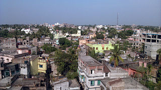
Rampurhat is a city and a municipality in Birbhum district in the Indian state of West Bengal. It is the headquarters of the Rampurhat subdivision. According to Census 2011 Rampurhat is the third most populous city in Birbhum district and 82nd most populous city in West Bengal. Rampurhat is a rapidly growing township It is near the West Bengal / Jharkhand border. Rampuhat is an important city of Birbhum district as it has dynamic connectivity with the other places of West Bengal and neighboring states via state highways, national highway and rail route. Rampurhat Junction is one of the busiest railway stations in eastern India.
Burdwan Division is one of the 5 administrative division in the Indian state of West Bengal. The headquarters of the Burdwan division is situated at Chinsurah while the largest city in this division is Asansol. This division is known for its huge reserve of coal, mainly in the districts of Paschim Bardhaman and Birbhum.
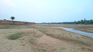
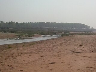
The Mayurakshi is a major river in Jharkhand and West Bengal, India, with a long history of devastating floods.
Nalhati is a town and a municipality in Rampurhat subdivision of Birbhum District in the Indian state of West Bengal near the West Bengal / Jharkhand border. This town is named after the Shakti peeth Nalhateshwari temple, which according to the mythologies is situated where the "nala" i.e. throat of goddess Shakti had fallen. It is one of the 51 Shakti Peethas in India. Nalhati Municipality was established in 2000.
The Bakreshwar River is a tributary of the Mayurakshi River. It originates in Santhal Parganas division of Jharkhand. It then flows through Birbhum district and meets the Kopai River. The combined waters flow into the Mayurakshi River in Murshidabad district.
The Hinglo River is a tributary of the Ajay River in the Indian states of Jharkhand and West Bengal.

The Dwarka River is a tributary of Bhagirathi.
Mayureswar is a village and gram panchayat in Mayureswar II CD Block in Rampurhat subdivision of Birbhum district in the Indian state of West Bengal.
Hansan is a village and a gram panchayat in Rampurhat II CD Block in Rampurhat subdivision of Birbhum district in the Indian state of West Bengal
Paikar is a village in the Murarai II community development block in the Rampurhat subdivision of Birbhum district in the Indian state of West Bengal.
Chakmandala is a village in Rampurhat I CD Block in Rampurhat subdivision of Birbhum district in the Indian state of West Bengal
Basoa is a village in Rampurhat II CD Block in Rampurhat subdivision of Birbhum district in the Indian state of West Bengal
Satpalsa is a village in Mayureswar II CD Block in Rampurhat subdivision of Birbhum district in the Indian state of West Bengal.
Lokpara is a village in Mayureswar II CD block in Rampurhat subdivision of Birbhum district.
Madian is a village in Mayureswar I CD block in Rampurhat subdivision of Birbhum district.
Barua Gopalpur is a census town in Murarai I CD block in Rampurhat subdivision of Birbhum district.
Ambhua is a census town in Murarai I CD block in Rampurhat subdivision of Birbhum district.
Kashimnagar is a census town in Murarai II CD block in Rampurhat subdivision of Birbhum district.
Bishnupur is a census town in Rampurhat II CD block in Rampurhat subdivision of Birbhum district.
Fatehpur is a census town and a neighbourhood of Mallarpur town in Mayureswar I CD block of Rampurhat subdivision in Birbhum district.

