Usri Falls

Last updated

Usri Falls
Ushri falls.JPG
Ushri falls
Jharkhand relief map.svg
Red pog.svg
Usri Falls
Usri Falls
Location Giridih district, Jharkhand, India
Coordinates 24°5′47″N86°22′14″E / 24.09639°N 86.37056°E / 24.09639; 86.37056
Elevation288 metres (945 ft)
Total height12 metres (39 ft)
Number of drops3
WatercourseUsri River

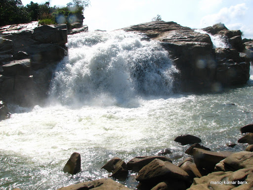
Usri Falls is a waterfall located in Giridih district in the Indian state of Jharkhand. It is a popular tourist and picnic spot. [1] [2] [3] Ushree means a "beautiful source".

Contents

Geography

Usri Falls
Cities, towns and locations in the Giridih district in North Chotanagpur Division
M: municipality, CT: census town, R: rural/ urban centre, H: historical/ religious/ tourist centre
Owing to space constraints in the small map, the actual locations in a larger map may vary slightly

Location

Usri Falls is located 13 kilometres (8.1 mi) east of the Giridih town on the road to Tundi. [3] Taxis, tongas and auto-rickshaws are available. [1] [4] [5]

Note: The map alongside presents some of the notable locations in the district. All places marked in the map are linked in the larger full screen map.

Description

The Usri River, a tributary of the Barakar River, flows down a steep gorge. The Usri Falls drop some 12 metres (39 ft) in three separate streams. It is surrounded by dense forest. [4]

The character of the gneissic complex of this region is well exposed. Some of the rocks have been split up into blocks of huge dimension whose polished and clean surfaces have been chequered by veins of various hues. The profile of the river bed changes after passing through the falls. The lower portion is mostly flat, slightly undulating, which gives way to gorge like form. [6] The government has taken several steps to develop the area as a prominent tourist spot along with Khandoli Dam and Parasnath. [7] [8]

See also

Related Research Articles

<span class="mw-page-title-main">Victoria Falls</span> Waterfall on the Zambezi River in Zambia and Zimbabwe

Victoria Falls is a waterfall on the Zambezi River in southern Africa, which provides habitat for several unique species of plants and animals. It is located on the border between Zambia and Zimbabwe and is one of the world's largest waterfalls, with a width of 1,708 m (5,604 ft).

<span class="mw-page-title-main">Tourism in India</span>

Tourism in India is 4.6% of the country's gross domestic product (GDP). Unlike other sectors, tourism is not a priority sector for the Government of India. Forbes magazine ranked India as the 7th most beautiful country in 'The 50 Most Beautiful Countries In The World' rankings. The World Travel and Tourism Council calculated that tourism generated 13.2 lakh crore (US$170 billion) or 5.8% of India's GDP and supported 32.1 million jobs in 2021. Even though, these numbers were lower than the pre-pandemic figures; the country's economy witnessed a significant growth in 2021 after the massive downturn during 2020. The sector is predicted to grow at an annual rate of 7.8% to 33.8 lakh crore (US$420 billion) by 2031. India has established itself as the 5th largest global travel healthcare destination with an estimated market size of around $9 billion in 2019, out of the total global travel healthcare industry of $44.8 billion(2019). In 2014, 184,298 foreign patients travelled to India to seek medical treatment.

<span class="mw-page-title-main">Chota Nagpur Plateau</span> Plateau of India

The Chota Nagpur Plateau is a plateau in eastern India, which covers much of Jharkhand state as well as adjacent parts of Chhattisgarh, Odisha, West Bengal and Bihar. The Indo-Gangetic plain lies to the north and east of the plateau, and the basin of the Mahanadi river lies to the south. The total area of the Chota Nagpur Plateau is approximately 65,000 square kilometres (25,000 sq mi).

<span class="mw-page-title-main">Jonha Falls</span> Waterfall in Ranchi district, Jharkhand

The Jonha Falls is a waterfall located in Ranchi district in the Indian state of Jharkhand. The best way to reach water fall without using 722 steps of stairs through Jonha Fall Resort Road. You can see beautiful and natural scenes surrounded by Forest, Mountain and Rivers.

<span class="mw-page-title-main">Rajrappa</span> Waterfall in Jharkhand, India

Rajrappa is a waterfall and a pilgrimage centre in the Chitarpur CD block in the Ramgarh subdivision of the Ramgarh district in the Indian state of Jharkhand.

<span class="mw-page-title-main">Giridih</span> City in Jharkhand, India

Giridih is headquarters of the Giridih district of Jharkhand state, India. The city of Giridih is known for its industrial and health sectors, as well as its scenery. Giridih houses the Giridih Coalfield which is one of the oldest coalfields to be worked in India. Giridih is one of the six Data Processing Centres of Data Processing Division (DPD) of National Sample Survey Office (NSSO). Before 1972, Giridih was part of Hazaribagh district.

<span class="mw-page-title-main">Netarhat</span> Town in Jharkhand, India

Netarhat is a hill station in Latehar district in the Indian state of Jharkhand. It is also referred to as the "Queen of Chotanagpur", and is a hill station. The town is also famous for Netarhat Residential School, set up in 1954.

<span class="mw-page-title-main">Giridih district</span> District of Jharkhand in India

Giridih district is one of the twenty-four districts of Jharkhand state, India, and Giridih is the administrative headquarters of this district. As of 2011 it is the third most populous district of Jharkhand, after Ranchi and Dhanbad.

Giridih is a community development block that forms an administrative division in the Giridih Sadar subdivision of the Giridih district in the Indian state of Jharkhand.

<span class="mw-page-title-main">Madhupur, Deoghar</span> Town in Jharkhand, India

Madhupur is a town with a municipality in Deoghar district in the Indian state of Jharkhand. It is a subdivisional town, famous for the production of sweets and widely considered a popular health resort for tourists as the water and overall climate is said to cure many stomach and digestion ailments.

<span class="mw-page-title-main">Chitrakote Falls</span> Waterfall on the Indravati River in Chhattisgarh, India

The Chitrakote Falls is a natural waterfall on the Indravati River, located approximately 38 kilometres (24 mi) to the west of Jagdalpur, in Bastar district in the Indian state of Chhattisgarh.

Sadni Falls is a waterfall located about 3 kilometres (1.9 mi) from Rajadera village in Gumla district in the Indian state of Jharkhand.

<span class="mw-page-title-main">Dassam Falls</span> Waterfalls in Ranchi, Jharkhand

The Dassam Falls is a waterfall located near Taimara village in Bundu police station of Ranchi district in the Indian state of Jharkhand.

<span class="mw-page-title-main">Hundru Falls</span> Waterfall on the Subarnarekha River in Jharkhand, India

The Hundru Falls is a waterfall located in Ranchi district in the Indian state of Jharkhand. It is the 34th highest waterfall in India. It is one of the most famous tourist places in the region.

<span class="mw-page-title-main">Panchghagh Falls</span> Waterfall in Jharkhand, India

Panchghagh Falls is a waterfall located in Khunti district in the Indian state of Jharkhand.

<span class="mw-page-title-main">Lower Ghaghri Falls</span> Waterfall in Jharkhand, India

Lower Ghaghri Falls is located 10 kilometres (6.2 mi) from Netarhat in Latehar district in the Indian state of Jharkhand. It is the 33rd highest waterfall in India. It is known for its mesmerizing beauty and a major tourist attraction in Jharkhand.

<span class="mw-page-title-main">Harihar Dham</span> Hindu temple in Jharkhand, India

Harihar Dham temple, commonly known as Harihar Dham located in Bagodar, Giridih, of Indian state of Jharkhand has the distinction of having Shivalinga.

<span class="mw-page-title-main">Khandoli Dam</span> Dam in Giridih, Jharkhand

Khandoli Dam is a dam located 10 km North-East of Giridih town towards Bengabad in Jharkhand, India. Khandoli is also an important tourist spot at the foot of the Khandoli hill. The reservoir of the Khandoli dam provides water supply to more than one lakh residents of the Giridih city.

<span class="mw-page-title-main">Aharbal</span> Locality in Kashmir

Aharbal is a hill station in the south-western part of Kashmir Valley in the Indian union territory of Jammu and Kashmir, south of the summer capital of Srinagar. Aharbal Waterfall is also known as Niagara Waterfall of Kashmir.

Tourism in Jharkhand refers to tourism in the Indian state of Jharkhand. Jharkhand is known for its waterfalls, hills and holy places.

References

  1. 1 2 "Giridih Tourism". Official Website of Giridih. Retrieved 7 March 2012.
  2. "Jharkhand Fast Facts". Jharkhand. Envis Centre on Ecotourism, Govt of India. Archived from the original on 7 February 2012. Retrieved 7 March 2012.
  3. 1 2 Dr. B.R. Kishore, Dr. Shiv Sharma (2008). India - A Travel Guide. Diamond Pocket Books (P) Ltd. p. 302. ISBN   9788128400674.
  4. 1 2 "Giridih attractions". sulekha.com. Retrieved 17 April 2010.
  5. "Usri Falls". india9.com. Retrieved 20 April 2010.
  6. Sharma, Hari Shanker. Perspectives in geomorphology, Volume 1 By Hari Shanker Sharma . Retrieved 17 April 2010.
  7. "Ire over park entry fee". The Telegraph (Calcutta) . 10 January 2008. Archived from the original on 4 March 2016. Retrieved 9 March 2012.
  8. Prasad, Basudeo (1 January 2009). "Sustainable eco-tourism development: A case study of Jharkhand state". Spectrum. 1 (1): 62. Retrieved 6 April 2012.
External images
Searchtool.svg Picture of Usri Falls, from here retrieved 8.03.2012
Searchtool.svg Picture2 of Usri Falls, from here retrieved 8.03.2012
Searchtool.svg Picture3 of Usri Falls, from here retrieved 8.03.2012
External videos
Nuvola apps kaboodle.svg Video of Usri Falls Giridih Jharkhand
Nuvola apps kaboodle.svg Video of Usri Falls by Dept. of Tourism, Govt of Jharkhand