A cantonment is a military quarters. In Bangladesh, India, Pakistan and other parts of South Asia, a cantonment refers to a permanent military station. In United States military parlance, a cantonment is, essentially, "a permanent residential section of a fort or other military installation," such as Fort Hood.

Ramgarh Cantonment, usually referred to as Ramgarh Cantt or just Ramgarh is a cantonment town, belonging to the Ramgarh district of the Indian state of Jharkhand. Historically, a subdivision of the larger Hazaribag district, Ramgarh was finally elevated to a district status on 12 September 2007 largely to ease administrative hardships.

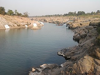
Kiul Junction railway station, is one of the major railway junctions in Danapur division of East Central Railway. Kiul is connected to metropolitan areas of India, by the Howrah–Delhi main line via Mugalsarai–Patna route which runs along the historic Grand Trunk Road. The Danapur railway division's main line crosses Sahibganj loop line at the Kiul Junction. The main line crosses the Kiul River between Kiul Junction and Lakhisarai Junction. The Gaya–Kiul line also starts from the Kiul Junction.
Ramgarh district is one of the 24 districts in the Indian state of Jharkhand. It was also a military district during the British Regime, referred to then as Ramgarh district.

Jasidih Junction is the one of the cleanest railway station serving Jasidih which is the satellite town of Deoghar city in the Deoghar district in the Indian state of Jharkhand.

Dumka railway station is a railway station serving the city of Dumka in Dumka district in the Indian state of Jharkhand on the Jasidih–Rampurhat section. It is in the Asansol division of the Eastern Railway zone of the Indian Railways. It has an average elevation of 136 metres (446 ft).
Jamui railway station, station code JMU, serves the headquarters of Jamui district in the Indian state of Bihar. It is one of the major railway stations in Danapur division of East Central Railway. Jamui is connected to metropolitan areas of India, by the Delhi–Kolkata main line via Mugalsarai–Patna route which runs along the historic Grand Trunk Road.

Rampurhat Junction railway station is one of the busiest railway stations of Eastern Railway zone and it is the largest and busiest railway station of Birbhum district of West Bengal. It is a "NSG-3" category station. The station is under Howrah railway division is the 3rd busiest station in this division after Howrah and Burdwan railway station. It is 207 kilometres away from Howrah Junction. This station is famous for its connectivity with the neighbouring districts and states and also for the Hindu pilgrims visiting to Tarapith Maa Tara Temple which is just 9 km away from the station. Station code RPH, it is the railway station serving the city of Rampurhat. Rampurhat station is connected to Kolkata, Bhubaneswar, Vishakhapatnam, Hyderabad, Chennai, Kanyakumari, Bengaluru, Kochi, Thiruvananthapuram, Mumbai, Surat, Delhi, Gaya, Ranchi, Asansol, Jamalpur, Bhagalpur, Siliguri, Guwahati, Dibrugarh, Silchar, Agartala and almost every part of India. More than 100 express and passengers trains including 22 originating trains pass through the Rampurhat station everyday. This station has also a Marshalling Yard for Goods Trains and carshed for passenger rakes and engines.
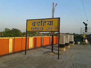
Barhiya, station code BRYA, serves the municipal city of Barahiya in the Lakhisarai district in the Indian state of Bihar. The station belongs to the Danapur railway division of East Central Railway. Barhiya is connected to metropolitan areas of India, by the Delhi–Kolkata main line via Mugalsarai–Patna route which runs along the historic Grand Trunk Road. Railways and roads are the main means of transport in the Barhiya region. Due to its location on Howrah–Patna–Mughalsarai main line, most of the Patna, Barauni-bound express trains coming from Howrah, Sealdah, Ranchi, Tatanagar, stop here. The Sahibganj loop line leaves Munger district, and enters Lakhisarai district near the Barhiya Station.

Danapur Railway Station or Danapur Junction, station code DNR, is a large railway station and headquarters of Danapur railway division of East Central Railway. Danapur is connected to metropolitan areas of India by the Delhi–Kolkata main line via Mughalsarai–Patna route. It is in Khagaul city about 6 km from Danapur Cantonment, in Patna district in the Indian state of Bihar.
Hatia railway station, station code HTE, is the railway station serving the capital city of Ranchi in the Ranchi district in the Indian state of Jharkhand. Hatia Station belongs to the Ranchi division of the South Eastern Railway Zone of the Indian Railways. Hatia railway station is connected to most of the major cities in India by the railway network. It is situated on Ranchi–Rourkela railway section.

Namkom railway station, station code NKM, is the railway station serving the capital city of Ranchi in the Ranchi district in the Indian state of Jharkhand. Namkom station belongs to the Ranchi division of the South Eastern Railway zone of the Indian Railways.

Muri Junction, station code MURI, is the railway station serving the remote town of Muri in the Ranchi district in the Indian state of Jharkhand. Muri Junction belongs to the Ranchi division of the South Eastern Railway zone of the Indian Railways.
Lohardaga Station, station code LAD, is the railway station serving the city of Lohardaga which is the headquarters of the Lohardaga district in the Indian state of Jharkhand. Lohardaga station belongs to the Ranchi division of the South Eastern Railway zone of the Indian Railways.
Jhalda station, station code JAA, is the railway station serving the city of Jhalda which is in the Purulia district in the Indian state of West Bengal. Jhalda railway station belongs to the Ranchi division of the South Eastern Railway zone of the Indian Railways. Jhalda railway station is located between Muri and Bokaro Steel City.
Bano railway station, station code BANO, is the railway station serving the village of Bano in the Simdega district in the Indian state of Jharkhand. Bano Station belongs to the Ranchi division of the South Eastern Railway zone of the Indian Railways.

Barkakana Junction railway station,, serves Barkakana and the surrounding coal mining areas in Ramgarh district in the Indian state of Jharkhand.
Barkichampi station, station code BICI, is the railway station in lohardaga district which connects Lohardaga and Tori of Jharkhand. Barkichampi station belongs to the Ranchi division of the South Eastern Railway zone of the Indian Railways.

Ranchi Road railway station is a compact railway station in Ramgarh district, Jharkhand. Its code is RRME. It serves Ramgarh township area as well as other areas of the Ramgarh district. The station consists of two platforms. The platforms are well sheltered. It is located on Gomoh–Barkakana branch line.

Basukinath railway station is at Basukinath city in Dumka district in the Indian state of Jharkhand on the Jasidih–Rampurhat section. It is in the Asansol Division of the Eastern Railway zone of the Indian Railways. It has an average elevation of 207 metres (679 ft).
