Giridih district

Last updated
Giridih district
Shikharji Parasnath Giridih.jpg
Giridih in Jharkhand (India).svg
Location of Giridih district in Jharkhand
CountryFlag of India.svg  India
State Government banner of Jharkhand.png Jharkhand
Division North Chotanagpur
Headquarters Giridih
Government
  District CommissionerMr. Naman Priyesh Lakra
   Lok Sabha constituencies 1. Kodarma, 2. Giridih
   Vidhan Sabha constituencies 6
Area
  Total4,962 km2 (1,916 sq mi)
Population
 (2011)
  Total2,445,474 [1]
   Urban
06.41
Demographics
   Literacy 65.12 per cent [1] [2]
  Sex ratio940
Time zone UTC+05:30 (IST)
Website giridih.nic.in

Giridih district is one of the twenty-four districts of Jharkhand state, India, and Giridih is the administrative headquarters of this district. As of 2011 it is the third most populous district of Jharkhand (out of 24), after Ranchi and Dhanbad. [1]

Contents

History

Giridh district was a part of Kharagdiha estate till late 18th century. During the British Raj Giridih became a part of Jungle Terry. After Kol Uprising in 1831, the parganas of Ramgarh, Kharagdiha, Kendi and Kunda became parts of the South-West Frontier Agency and were formed into a division named Hazaribag as the administrative headquarters. The Kharagdiha Rajas were settled as Rajas of Raj Dhanwar in 1809, and the Kharagdiha gadis were separately settled as zamindari estates. Some of the notable Kharagdiha Zamindari estates were Koderma, Gadi Palganj, Ledo Gadi, Gande Gadi, Ghoranji Gadi and Gadi Sirsia. [3] Giridih district was created on 6 December 1972 by carving some parts of Hazaribagh district. In 1999 part of it became Bokaro district. [4]

It is currently a part of the Red Corridor. [5] The 15,000-capacity football and cricket stadium named Giridih Stadium is the largest sports venue by capacity in the region. It is located in the town of Mahthadih.

Geography

The district, covering an area of around 4854 km², is bounded on the north by Jamui district and Nawada district of Bihar state, on the east by the districts of Deoghar and Jamtara, on the south by Dhanbad and Bokaro, and on the west by Hazaribagh and Koderma districts.

Giridih has an average elevation of 289 metres (948 feet). Śrī Sammeta Shikharji also known as the Parasnath Hills,it is one of the holiest place of Jainism, located in Giridih is the highest mountain peak in Jharkhand. It is a conical granite peak located 4,477 feet (1,382 metres) above the sea level. [6] [7]

Gawan and Tisari blocks of the district have several mica mines, and coal is found abundantly at several places throughout the district. [7]

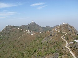
Parasnath Hills are located in the district. There are two major rivers, namely, the Barakar River and the Sakri River. Barakar River passes through Birni and Pirtand blocks. Sakari river drains the areas of Deori and Gawan blocks. There are several smaller rivers, including Usri, with a major tourist attraction - Usri Falls.

Administration

Blocks

Giridih district comprises the following 13 blocks:

Subdivisions

Following are the four subdivision of the district: [8]

  1. Giridih subdivision
  2. Bagodar-Sariya subdivision
  3. Khorimahua subdivision
  4. Dumri subdivision

Economy

In 2006 the Indian government named Giridh one of the country's 250 most backward districts (out of a total of 640). [9] It is one of the 21 districts in Jharkhand currently receiving funds from the Backward Regions Grant Fund Programme (BRGF). [9]

The DDP of Giridih District is ₹1,97,771(2003-04) and Income Per Capita is ₹9921(2003-04).

Divisions

There are six Vidhan Sabha (legislative assembly) constituencies in this district. Dhanwar, Bagodar, Jamua and Gandey assembly constituencies are part of Kodarma constituency. Giridih and Dumri assembly constituencies are part of Giridih constituency. [10]

Demographics

Historical population
YearPop.±% p.a.
1901375,866    
1911411,172+0.90%
1921407,450−0.09%
1931484,161+1.74%
1941558,821+1.44%
1951618,129+1.01%
1961747,946+1.92%
1971937,092+2.28%
19811,161,066+2.17%
19911,496,878+2.57%
20011,905,343+2.44%
20112,445,474+2.53%
source: [11]
Religions in Giridih district (2011) [12]
ReligionPercent
Hinduism
75.90%
Islam
20.80%
Sarna
2.42%
Christianity
0.60%
Other or not stated
0.28%

According to the 2011 census Giridih district has a population of 2,445,474 [1] roughly equal to the nation of Kuwait [13] or the US state of New Mexico. [14] This gives it a ranking of 182nd in India (out of a total of 640). [1] The district has a population density of 497 inhabitants per square kilometre (1,290/sq mi) . Its population growth rate over the decade 2001-2011 was 28.33%. Giridih has a sex ratio of 943 females for every 1000 males, and a literacy rate of 65.12%. 8.51% of the population lives in urban areas. Scheduled Castes and Scheduled Tribes made up 13.31% and 9.74% of the population respectively. [1]

Languages of Giridih district (2011) [15]

   Khortha (68.7%)
   Hindi (13.55%)
   Santali (8.99%)
   Urdu (7.47%)
  Others (1.29%)

At the time of the 2011 Census of India, 68.71% of the population in the district spoke Khortha, 13.55% Hindi, 8.99% Santali and 7.47% Urdu as their first language. [15]

Khortha, a blend of Magahi and Bengali, is the main language spoken in Giridih district. The tribal people speak Santhali.

Flora and fauna

The district has rich forest resources and have several jungles of sal trees and bamboos, and a variety of other indigenous trees. Among other common trees are bamboo, semal, Mahua, palash, kusum, kend, Asian pear and bhelwa. [7] Parasnath hills have a number of plants having medicinal use. Leopards, bears, jackals, wild pigs, and hares are the wild animals found in certain parts of the district which have thick forests.

Politics

No.ConstituencyNamePartyAllianceRemarks

28 Dhanwar Babulal Marandi Bharatiya Janata Party NDA JVM (P) merged into BJP [16]
29 Bagodar Vinod Kumar Singh Communist Party of India (Marxist–Leninist) Liberation UPA
30 Jamua Kedar Hazra Bharatiya Janata Party NDA
31 Gandey Dr. Sarfraz Ahmad Jharkhand Mukti Morcha UPA
32 Giridih Sudivya Kumar Jharkhand Mukti Morcha UPA
33 Dumri Jagarnath Mahto Jharkhand Mukti Morcha UPA Cabinet Minister

Tourism

Related Research Articles

<span class="mw-page-title-main">Giridih</span> City in Jharkhand, India

Giridih is headquarters of the Giridih district of Jharkhand state, India. The city of Giridih is known for its industrial and health sectors, as well as its scenic beauty. Giridih houses the Giridih Coalfield which is one of the oldest coalfields to be worked in India. Giridih is one of the six Data Processing Centres of Data Processing Division (DPD) of National Sample Survey Office (NSSO). Before 1972, Giridih was part of Hazaribagh district.

Bagodar is a community development block that forms an administrative division in the Bagodar-Saria subdivision of the Giridih district in the Indian state of Jharkhand.

Birni is a community development block that forms an administrative division in the Bagodar-Saria subdivision of the Giridih district in the Indian state of Jharkhand.

Dhanwar, also known as Rajdhanwar, is a census town in the Dhanwar CD block in the Khori Mahua subdivision of the Giridih district in the Indian state of Jharkhand. It is a busiest business destination in the district Giridih. Dhanwar is surrounded by river from three sides. This town is very famous for Hindu verdict festival Chhath puja in Jharkhand state. Every year, around 4 lakh people visit Dhanwar chhath ghat called "Rajghat" during the festival. Decoration of Rajghat occurs at huge-level that fascinates the visitors.

Dumri is a community development block that forms an administrative division in the Dumri sub-division of the Giridih district in the Indian state of Jharkhand.

Gandey block is a community development block that forms an administrative division in the Giridih Sadar subdivision of the Giridih district in the Indian state of Jharkhand.

Gawan block is a community development block that forms an administrative division in the Khuri Mahua subdivision of the Giridih district in the Indian state of Jharkhand.

Giridih is a community development block that forms an administrative division in the Giridih Sadar subdivision of the Giridih district in the Indian state of Jharkhand.

Tisri is a community development block that forms an administrative division in the Khori Mahuwa subdivision of the Giridih district in the Indian state of Jharkhand.

<span class="mw-page-title-main">Hazaribagh Road railway station</span>

Hazaribagh Road is a railway station on the Grand Chord line of East Central Railway. The place is locally known as Sariya, in Sariya CD Block in Bagodar-Saria subdivision in Giridih district in the Indian state of Jharkhand.

Bagodar is a village in the Bagodar CD block in the Bagodar-Saria subdivision of the Giridih district in the Indian state of Jharkhand.

Kharagdiha is a village in the Jamua CD block in the Khori Mahua subdivision of the Giridih district in the Indian state of Jharkhand. It had been known as Curruckdea or Curruckdeah during the British Raj.

Sariya Mahraj Mathur is a community development block that forms an administrative division in the Bagodar-Saria subdivision of the Giridih district in the Indian state of Jharkhand.

Dhanwar is a community development block that forms an administrative division in the Khori Mahuwa subdivision of the Giridih district in the Indian state of Jharkhand.

Jamua is a community development block that forms an administrative division in the Khori Mahuwa subdivision of the Giridih district in the Indian state of Jharkhand.

Koderma is a community development block that forms an administrative division in the Koderma subdivision of the Koderma district, Jharkhand state, India.

Giridih Sadar subdivision is an administrative subdivision of the Giridih district in the state of Jharkhand, India.

Birni is a village in the Birni CD block in the Bagodar-Saria subdivision of the Giridih district in the Indian state of Jharkhand.

Deori is a village in the Deori CD block in the Khori Mahuwa subdivision of the Giridih district in the Indian state of Jharkhand.

<span class="mw-page-title-main">Madhuban, Giridih</span> Village in Jharkhand, India

Madhuban is a village in the Pirtand CD block in the Dumri subdivision of the Giridih district in the Indian state of Jharkhand.

References

  1. 1 2 3 4 5 6 "District Census Handbook: Giridih" (PDF). censusindia.gov.in. Registrar General and Census Commissioner of India. 2011.
  2. "District-specific Literates and Literacy Rates, 2001". Registrar General, India, Ministry of Home Affairs. Retrieved 2010-10-10.
  3. Hazaribagh District Gazetteer.
  4. Law, Gwillim (2011-09-25). "Districts of India". Statoids. Retrieved 2011-10-11.
  5. "83 districts under the Security Related Expenditure Scheme". IntelliBriefs. 2009-12-11. Retrieved 2011-09-17.
  6. "Jharkhand". Encyclopædia Britannica. Retrieved 7 March 2012.
  7. 1 2 3 "Official website of the Giridih district" . Retrieved 7 March 2012.
  8. "Giridih". Blocks. District Administration, Giridih. Retrieved 8 November 2015.
  9. 1 2 Ministry of Panchayati Raj (September 8, 2009). "A Note on the Backward Regions Grant Fund Programme" (PDF). National Institute of Rural Development. Archived from the original (PDF) on April 5, 2012. Retrieved September 27, 2011.
  10. "Election". Giridih district website. Archived from the original on 2009-06-19.
  11. "Table A-02 Decadal Variation in Population Since 1901: Jharkhand" (PDF). census.gov.in. Registrar General and Census Commissioner of India.
  12. "Table C-01 Population By Religion: Jharkhand". census.gov.in. Registrar General and Census Commissioner of India.
  13. US Directorate of Intelligence. "Country Comparison:Population". Archived from the original on 2011-09-27. Retrieved 2011-10-01. Kuwait 2,595,62
  14. "2010 Resident Population Data". U. S. Census Bureau. Archived from the original on 2011-07-21. Retrieved 2011-09-30. New Mexico - 2,059,179
  15. 1 2 "Table C-16 Population by Mother Tongue: Jharkhand". censusindia.gov.in. Registrar General and Census Commissioner of India.
  16. Special Correspondent (2020-06-09). "Babulal Marandi announces merger of JVM(P) and BJP on Feb. 17". The Hindu. ISSN   0971-751X . Retrieved 2022-02-28.

Coordinates: 24°10′48″N86°19′12″E / 24.18000°N 86.32000°E / 24.18000; 86.32000