This article needs additional citations for verification .(July 2009) |
Godda district | |
|---|---|
 View of Manokamna Hill in Lakhanpahari | |
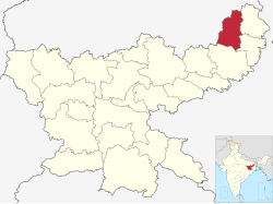 Location of Godda district in Jharkhand | |
| Country | |
| State | |
| Division | Santhal Pargana |
| Headquarters | Godda |
| Government | |
| • Lok Sabha constituencies | Godda (shared with Deoghar and Dumka districts) |
| • Vidhan Sabha constituencies | 3 |
| Area | |
• Total | 2,110 km2 (810 sq mi) |
| Population (2011) | |
• Total | 1,313,551 |
| • Density | 623/km2 (1,610/sq mi) |
| Demographics | |
| • Literacy | 56.40 per cent |
| • Sex ratio | 933 |
| Website | Official website |
Godda district is one of the twenty-four districts of Jharkhand state in eastern India. It lies in the north eastern part of the state. The geographical area that now comprises Godda district used to be part of the erstwhile Santhal Parganas district. Godda town is the headquarters of Godda district. The area of the district is 2110 km², with a population of around 1,313,551. [1]

