Barharwa

Last updated

Barharwa
Bindudham
Bandana Festival.jpg
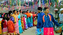
Bandana festival in the outskirts of Barharwa
India Jharkhand location map.svg
Red pog.svg
Barharwa
Location in Jharkhand, India
India location map 3.png
Red pog.svg
Barharwa
Barharwa (India)
Coordinates: 24°51′28″N87°46′38″E / 24.857778°N 87.777167°E / 24.857778; 87.777167
CountryFlag of India.svg  India
State Jharkhand
District Sahibganj
Government
  TypeNagar Panchayat
  BodyBarharwa Nagar Panchayat
  ChairmanShyamal Das
  Deputy ChairmanLokesh Kushwaha
Area
  Total4.06 km2 (1.57 sq mi)
Population
 (2011)
  Total12,617
  Density3,100/km2 (8,000/sq mi)
Languages (*For language details see Barharwa (community development block)#Language and religion)
  Official Hindi, Urdu
Time zone UTC5:30 (IST)
Vehicle registration JH 18
Lok Sabha constituency Rajmahal
Vidhan Sabha constituency Pakaur
Website sahibganj.nic.in

Barharwa is a town with a Nagar panchayat in the Rajmahal subdivision of the Sahibganj district in the Indian state of Jharkhand.

Contents

Geography

Barharwa
Cities, towns and locations in the Sahibganj, Godda and Pakur districts in Santhal Pargana Division
M: municipality, CT: census town, R: rural/ urban centre, H: historical/ religious/ tourist centre
Owing to space constraints in the small map, the actual locations in a larger map may vary slightly

Location

Barharwa is a nagar panchayat. [1] [2]

Barharwa is located at 24°51′28″N87°46′38″E / 24.857778°N 87.777167°E / 24.857778; 87.777167 .

Barharwa has an area of 4.06 square kilometres (1.57 sq mi). [3]

Overview

The map shows a hilly area with the Rajmahal hills running from the bank of the Ganges in the extreme north to the south, beyond the area covered by the map into Dumka district. ‘Farakka’ is marked on the map and that is where Farakka Barrage is, just inside West Bengal. Rajmahal coalfield is shown in the map. The entire area is overwhelmingly rural with only small pockets of urbanisation. [4]

Note: The full screen map is interesting. All places marked on the map are linked and you can easily move on to another page of your choice. Enlarge the map to see what else is there – one gets railway links, many more road links and so on.

Demographics

According to the 2011 Census of India, Barharwa had a total population of 12,617, of which 6,550 (52%) were males and 6,067 (48%) were females. Population in the age range 0–6 years was 1,694. The total number of literate persons in Barharwa was 8,570 (78.46% of the population over 6 years). [3]

A newspaper report says that 9 villages have been added for the formation of Barharwa nagar panchayat in 2016 and the population rose to 24,133. This rise would obviously get reflected in the 2021 census. [2]

Infrastructure

According to the District Census Handbook 2011, Sahibganj, Barharwa covered an area of 4.06 km2. Among the civic amenities, it had 14 km roads with both open and closed drains, the protected water supply involved hand pump, uncovered well. It had 1,189 domestic electric connections, 105 road light points. Among the educational facilities it had 4 primary schools, 5 middle schools, 2 secondary schools, 2 senior secondary schools, 1 general degree college. Among the social, cultural and recreational facilities, it had 2 stadiums, 2 cinema theatres, 1 auditorium/ community hall, 1 public library,1 reading room. Three important commodities it produced were bidi, papad, aachar. It had the branch offices of 2 nationalised banks. [5]

Civic administration

Police station

Barharwa police station serves Barharwa CD block. [6] [7]

CD block HQ

Headquarters of Barharwa CD block is at Barharwa town. [8]

Transport

Barharwa Junction railway station is on the Sahibganj loop. The Barharwa–Azimganj–Katwa loop originates from Barharwa. [9]

Education

B.S.K. College, affiliated with Sido Kanhu Murmu University , was established at Barharwa. [10]

B.S.A. Mahila College, affiliated with Sido Kanhu Murmu University , was established at Barharwa. [11]

Related Research Articles

Sahebganj is a scenic town and a port city with the serene Ganga and sturdy hills in the Sahibganj subdivision of the Sahebganj district of Jharkhand state, India. It serves as headquarters for Sahibganj District, Sahibganj subdivision and Sahibganj. It is located on the north-east of Jharkhand and situated on the banks of Ganges. 17th May is the Foundation Day of the District, when Rajmahal and Pakur subdivisions of old Santhal Pargana district were carved out to form Sahibganj district.

Jamtara is a community development block that forms an administrative division in the Jamtara Sadar subdivision of the Jamtara district, Jharkhand state, India.

Sakrigali is a village in the Sahibganj CD block in the Sahibganj subdivision of the Sahibganj district in the Indian state of Jharkhand.

Udhwa is a village in the Uddhwa CD block in the Rajmahal subdivision of the Sahibganj district in the Indian state of Jharkhand.

Borio is a community development block that forms an administrative division in the Sahibganj subdivision of the Sahibganj district, Jharkhand state, India.

Barharwa is a community development block that forms an administrative division in the Rajmahal subdivision of the Sahibganj district, Jharkhand state, India.

Pathargama is a community development block that forms an administrative division in the Godda subdivision of the Godda district, Jharkhand state, India.

Ranishwar is a village in the Ranishwar CD block in the Dumka Sadar subdivision of the Dumka district in the Indian state of Jharkhand.

Nala is a village in Nala CD block in the Jamtara Sadar subdivision of the Jamtara district in the Indian state of Jharkhand.

Kundahit is a village in Kundhit CD block in the Jamtara Sadar subdivision of the Jamtara district in the Indian state of Jharkhand.

Dumka Sadar subdivision is the only administrative subdivision of the Dumka district in the Santhal Pargana division in the state of Jharkhand, India.

Tin Pahar is a census town in the Rajmahal CD block in the Sahibganj subdivision of the Sahibganj district in the Indian state of Jharkhand.

Berhait Santali is a census town in the Barhait CD block in the Sahibganj subdivision of the Sahibganj district in the Indian state of Jharkhand.

Berhait Bazar is a census town in the Barhait CD block in the Sahibganj subdivision of the Sahibganj district in the Indian state of Jharkhand.

Borio is a census town in the Borio CD block in the Sahibganj subdivision of the Sahibganj district in the Indian state of Jharkhand.

Dhamri is a village in Meharama CD block in Godda subdivision of Godda district in the Indian state of Jharkhand.

Parsa is a village in Mahagama CD block in Godda subdivision of Godda district in the Indian state of Jharkhand.

Pathargama is a village in the Pathargama CD block in the Godda subdivision of the Godda district in the Indian state of Jharkhand.

Basantrai is a village in the Basantrai CD block in the Godda subdivision of the Godda district in the Indian state of Jharkhand.

Kotalpokhar is a village in the Barharwa CD block in the Rajmahal subdivision of the Sahibganj district in the Indian state of Jharkhand.

References

  1. "Municipalities". Sahibganj district authorities. Retrieved 27 November 2020.
  2. 1 2 "नौ गांवों को मिलाकर बनी बरहरवा नगर पंचायत (Nine villages added to form Barharwa Nagar Panchayat)". Dainik Jagaran, 13 September 2016. Retrieved 28 November 2020.
  3. 1 2 "District Census Handbook, Sahibganj, Series 21, Part XII B" (PDF). Page 25: District Primary Census Abstract, 2011 census. Directorate of Census Operations Jharkhand. Retrieved 25 November 2020.
  4. Roychoudhury, P.C. "Bihar District Gazetteers: Santhal Parganas". Chapter I: General. Secretariat Press, Patna, 1965. Retrieved 5 December 2020.
  5. "District Census Handbook Sahibganj, Census of India 2011, Series 20, Part XII A" (PDF). Pages 896-902. Directorate of census Operations, Jharkhand. Retrieved 23 November 2020.
  6. "District Police Profile - Sahibganj". Jharkhand Police. Retrieved 27 November 2020.
  7. "Police". Government of Jharkhand. Retrieved 27 November 2020.
  8. "District Census Handbook, Sahibganj, Series 21, Part XII B" (PDF). Map of Sahibganj on the third page. Directorate of Census Operations Jharkhand. Retrieved 27 November 2020.
  9. Saxena, R. P. "Indian Railway History timeline". Archived from the original on 29 February 2012. Retrieved 28 November 2011.
  10. "Our Constituent Colleges". Sido Kanhu Murmu University. Retrieved 27 November 2020.
  11. "Our Affiliated Colleges". Sido Kanhu Murmu University. Retrieved 27 November 2020.