Sahebganj district

Last updated
Sahibganj district
Hills of rajmahal.jpg
Sahebganj in Jharkhand (India).svg
Location of Sahibganj district in Jharkhand
Coordinates(Sahebganj): 25°15′N87°39′E / 25.25°N 87.65°E / 25.25; 87.65
CountryFlag of India.svg  India
State Government banner of Jharkhand.png Jharkhand
Division Santhal Pargana
Government
   Lok Sabha constituencies Rajmahal
   Vidhan Sabha constituencies 3
Area
  Total2,063 km2 (797 sq mi)
Population
 (2011)
  Total1,150,567
  Density560/km2 (1,400/sq mi)
Demographics
   Literacy 53.73% [1]
  Sex ratio948
Time zone UTC+05:30 (IST)
Vehicle registration JH-18
Website http://sahibganj.nic.in/

Sahibganj district is one of the twenty-four districts of Jharkhand state, India, and Sahibganj is the administrative headquarters of this district.

Contents

Divisions

Sahibganj district is divided into two subdivions: Sahibganj subdivision and Rajmahal subdivision. It is further subdivided into nine Community development blocks:(Sahibganj subdivision) Sahibganj, Mandro, Borio, Barhait (Rajmahal subdivision) Taljhari, Rajmahal, Udhwa, Pathna and Barharwa. [2]

Economy

In 2006 the Ministry of Panchayati Raj named Sahibganj one of the country's 250 most backward districts (out of a total of 640). [3] It is one of the 24 districts in Jharkhand currently receiving funds from the Backward Regions Grant Fund Programme (BRGF). [3]

Demographics

Historical population
YearPop.±% p.a.
1901269,359    
1911280,249+0.40%
1921267,749−0.46%
1931306,039+1.35%
1941333,540+0.86%
1951346,615+0.39%
1961414,277+1.80%
1971507,180+2.04%
1981615,599+1.96%
1991736,835+1.81%
2001927,770+2.33%
20111,150,567+2.18%
source: [4]
Religions in Sahibganj district (2011) [5]
ReligionPercent
Hinduism
54.59%
Islam
34.61%
Christianity
7.23%
Sarna
3.34%
Other or not stated
0.23%

According to the 2011 census Sahibganj district has a population of 1,150,567, [6] roughly equal to the nation of Timor-Leste [7] or the US state of Rhode Island. [8] This gives it a ranking of 407th in India (out of a total of 640). [6] The district has a population density of 558 inhabitants per square kilometre (1,450/sq mi). [6] Its population growth rate over the decade 2001-2011 was 23.96%. [6] Sahibganj has a sex ratio of 948 females for every 1000 males, [6] and a literacy rate of 53.73%. 13.88% of the population lives in urban areas. Scheduled Castes and Scheduled Tribes make up 6.29% and 26.80% of the population respectively. [6]

Languages of Sahibganj district (2011) [9]

   Bengali (28.86%)
   Santali (21.86%)
   Hindi (16.71%)
   Khortha (11.42%)
   Urdu (6.33%)
   Bhojpuri (5.33%)
  'Other' Hindi (4.11%)
   Malto (3.68%)
  Others (1.70%)

At the time of the 2011 Census of India, 28.86% of the population in the district spoke Bengali, 21.86% Santali, 16.71% Hindi, 11.42% Khortha, 6.33% Urdu, 5.33% Bhojpuri and 3.68% Malto. 4.11% of the population spoke 'Others' under Hindi. [9]

Politics

DistrictNo.ConstituencyNamePartyAllianceRemarks
Sahebganj 1 Rajmahal Anant Kumar Ojha Bharatiya Janata Party NDA
2 Borio Lobin Hembrom Jharkhand Mukti Morcha UPA
3 Barhait Hemant Soren Jharkhand Mukti Morcha UPA Chief Minister

Localities

Related Research Articles

<span class="mw-page-title-main">Chitradurga district</span> District of Karnataka in India

Chitradurga district is an administrative district of Karnataka state in southern India. The city of Chitradurga is the district headquarters. Chitradurga gets its name from Chitrakaldurga, an umbrella-shaped lofty hill found there. Tradition dates Chitradurga District to the period of the Ramayana and Mahabharata. The whole district lies in the valley of the Vedavati River, with the Tungabhadra River flowing in the northwest. During the British times it was named Chitaldroog. The district was practically ruled by all the well known dynasties that ruled Karnataka. A historical places like Jain basadi of Heggere,a pilgrimage centre for Jain's in district.

<span class="mw-page-title-main">Godda district</span> District of Jharkhand in India

Godda district is one of the twenty-four districts of Jharkhand state in eastern India It lies in the northeastern part of the state. The geographical area that now comprises Godda district used to be part of the erstwhile Santhal Parganas district. Godda town is the headquarters of Godda district. The area of the district is 2110 km², with a population of around 1,313,551.

<span class="mw-page-title-main">Seraikela Kharsawan district</span> District of Jharkhand in India

Seraikela-Kharsawan district or Saraikella and Kharaswan district is one of the twenty-four districts of Jharkhand state in eastern India. Seraikela town is the district headquarters of Saraikela Kharsawan district. The district is well known for Seraikela Chhau, one of the three distinctive styles of the chhau dance. This district was carved out from West Singhbhum district in 2001. The district was formed from the Odia princely states of Seraikela and Kharaswan, after the independence of India.

<span class="mw-page-title-main">Hingoli district</span> District of Maharashtra in India

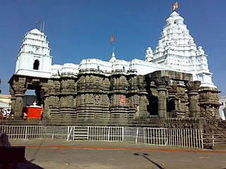
Hingoli district is an administrative district in the state of Maharashtra in India. The district is headquartered at Hingoli. The district occupies an area of 4,526 km2 and has a population of 11,77,345 of which 15.60% were urban. Hingoli was actually known as the Nizams military base as it was bordered with Vidharbha. In that era military troops, hospitals, veterinary hospital were in operation from Hingoli. Being a military base the city was one of the important and famous places of the Hyderabad state. One of the twelve Jyotirlinga shrines, the Aundha Nagnath is located in Hingoli district about 25 km south-west from district headquarter.

<span class="mw-page-title-main">Simdega district</span> District of Jharkhand in India

Simdega district is one of the twenty-four districts of Jharkhand state, India, and Simdega town is the administrative headquarters of this district. This district is the least population density district of jharkhand(2011).This district was carved out from erstwhile Gumla district on 30 April 2001. It is currently a part of the Red Corridor. As of 2011 it is the third least populous district of Jharkhand, after Lohardaga and Khunti districts.

<span class="mw-page-title-main">Latehar district</span> District of Jharkhand in India

Latehar district is one of the 24 districts of Jharkhand state in eastern India, and Latehar town is the administrative headquarters of this district. This district is part of Palamu division.

<span class="mw-page-title-main">Garhwa district</span> District of Jharkhand in India

Garhwa District is one of the twenty-four districts in the Indian state of Jharkhand. The Garhwa District is part of the Palamu division and has its administrative headquarters in Garhwa City.

<span class="mw-page-title-main">Giridih district</span> District of Jharkhand in India

Giridih district is one of the twenty-four districts of Jharkhand state, India, and Giridih is the administrative headquarters of this district. As of 2011 it is the third most populous district of Jharkhand, after Ranchi and Dhanbad.

<span class="mw-page-title-main">Pakur district</span> District of Jharkhand in India

Pakur district is one of the twenty-four districts of Jharkhand state, India, and Pakur is the administrative headquarters of this district. Pakur sub-division of Sahibganj district was carved out on 28 January 1994 to constitute Pakur District. The district, with a population of 900,422, and covering an area of 686.21 km2, is situated on the north-eastern corner of Jharkhand state.

<span class="mw-page-title-main">Jamtara district</span> District of Jharkhand in India

Jamtara district is one of the twenty-four districts of Jharkhand state in eastern India. Jamtara town is the administrative headquarters of this district. The district is situated between 23°10′ and 24°05′ north latitudes and 86°30′ and 87°15′ east longitudes.

<span class="mw-page-title-main">Dumka district</span> District of Jharkhand in India

Dumka district is one of the twenty-four districts of Jharkhand state in eastern India. Dumka is the administrative headquarters of this district. This district covers an area of 3716.02 km2. This district has a population of 1,321,442.

<span class="mw-page-title-main">Jalaun district</span> District of Uttar Pradesh in India

Jalaun district is a district of Uttar Pradesh, India. The district is named after the town of Jalaun, which was the former headquarters of a Maratha governor, but the administrative headquarters of the district is at Orai.

<span class="mw-page-title-main">Sant Kabir Nagar district</span> District of Uttar Pradesh in India

Sant Kabir Nagar district is one of the 75 districts of Uttar Pradesh state in northern India. Khalilabad is the district headquarters. Sant Kabir Nagar district is a part of Basti division. The total area of Sant Kabir Nagar district is 1,646 km2 (636 sq mi).

<span class="mw-page-title-main">Hamirpur district, Uttar Pradesh</span> District of Uttar Pradesh in India

Hamirpur district is one of the 75 districts of Uttar Pradesh state of India and Hamirpur town is the district headquarters. Hamirpur district is a part of Chitrakoot Division. The district occupies an area of 4,121.9 km². The district has a population of 1,104,285. As of 2011 it is the third least populous district of Uttar Pradesh, after Mahoba and Chitrakoot. Two major rivers Yamuna and Betwa meet here. On the banks of river Betwa lies the "Coarse sand" which is exported to many parts in U.P.

<span class="mw-page-title-main">Shravasti district</span> District of Uttar Pradesh in India

Shravasti district is one of the districts of the Uttar Pradesh state of India, with Bhinga town as its district headquarters. Shravasti district is a part of Devipatan Division. According to Government of India, it is among the 121 minority concentrated districts in India. It is the fourth most backward district in India, according to the 2018 Niti Aayog ranking. This district is the most poverty stricken district in the country.

<span class="mw-page-title-main">Mandla district</span> District of Madhya Pradesh in India

Mandla District is a district of Madhya Pradesh in central India. The town of Mandla is the administrative headquarters of the district. It is part of Jabalpur Division.

Sahibganj is a community development block that forms an administrative division in the Sahibganj subdivision of the Sahibganj district, Jharkhand state, India.

Taljhari is a community development block that forms an administrative division in the Rajmahal subdivision of the Sahibganj district, Jharkhand state, India.

Rajmahal is a community development block that forms an administrative division in the Rajmahal subdivision of the Sahibganj district, Jharkhand state, India.

Udhwa is a community development block that forms an administrative division in the Rajmahal subdivision of the Sahibganj district, Jharkhand state, India.

References

  1. "District-specific Literates and Literacy Rates, 2011". Registrar General, India, Ministry of Home Affairs. Retrieved 2011-12-11.
  2. "District Profile". Census 2011. Sahibganj district administration. Archived from the original on 4 March 2016. Retrieved 12 January 2016.
  3. 1 2 Ministry of Panchayati Raj (September 8, 2009). "A Note on the Backward Regions Grant Fund Programme" (PDF). National Institute of Rural Development. Archived from the original (PDF) on April 5, 2012. Retrieved September 27, 2011.
  4. "Table A-02 Decadal Variation in Population Since 1901: Jharkhand" (PDF). census.gov.in. Registrar General and Census Commissioner of India.
  5. "Table C-01 Population By Religion: Jharkhand". census.gov.in. Registrar General and Census Commissioner of India.
  6. 1 2 3 4 5 6 "District Census Handbook: Sahibganj" (PDF). censusindia.gov.in. Registrar General and Census Commissioner of India. 2011.
  7. US Directorate of Intelligence. "Country Comparison:Population". Archived from the original on June 13, 2007. Retrieved 2011-10-01. Timor-Leste 1,177,834 July 2011 est.
  8. "2010 Resident Population Data". U. S. Census Bureau. Retrieved 2011-09-30. Rhode Island 1,052,567
  9. 1 2 "Table C-16 Population by Mother Tongue: Jharkhand". censusindia.gov.in. Registrar General and Census Commissioner of India.