Vaishali district is a district in the Indian state of Bihar. It is a part of Tirhut division. Vaishali is known for being the birthplace of Mahavira of the Jain religion. Hajipur, its largest city and district headquarters, is known for its banana forest. The district is connected via the NH-77 and NH-322 highways, Gandhi Setu and Jay Prakash Setu Bridges over(Holy) Ganga River which connect the state capital Patna, the division headquarters Muzaffarpur, and the eastward district Samastipur.
Sheohar is an administrative district in the Mithila region of Bihar in India. The district headquarters are located at Sheohar, and the district is a part of Tirhut Division. This district was carved out of Sitamarhi district in 1994 due to the extreme efforts of Raghunath Jha, former Union Minister. Eminent Hindi Novelist, Dr. Bhagwati Sharan Mishra was the first District magistrate of Sheohar. Sivas used to have a guest house in the Mehsi town of his time, which is still located in the name of Raja Bazar in East Champaran.The district occupies an area of 349 km2 and has a population of 656,246. Sheohar is known for its greenery and cleanliness. Cadamba and teak are the principal trees of this district. Nilgai or blue bull is the regional animal of this area.

Madhepura district is one of the thirty-eight districts of Bihar state, India, and Madhepura town is the administrative headquarters of this district. Madhepura district is a part of Kosi division.

Katihar district is one of the thirty-eight districts of Bihar state in India, and Katihar city is the administrative headquarters of this district. The district is a part of Purnia Division. It is prominently known for its Katihar Junction Railway Station, which is a Category A1 station on the Barauni–Guwahati line. It has been included in the Aspirational Districts Program of the Government of India since 2018, to improve its socio-economic indicators. Katihar is the largest maize producing district of Bihar in 2022.
Aurangabad district is one of the thirty-eight districts of Bihar state, India. It is currently a part of the Red Corridor. Aurangabad is also called "Chittorgarh" of Bihar because the number of Suryavanshi Rajputs is very high here. Aurangabad played a major role in the Indian independence struggle, and is also the birthplace of eminent nationalist & first Deputy Chief Minister of state, Bihar Vibhuti Dr. Anugrah Narayan Sinha, a participant of Champaran Satyagraha who is regarded among makers of modern independent Bihar.
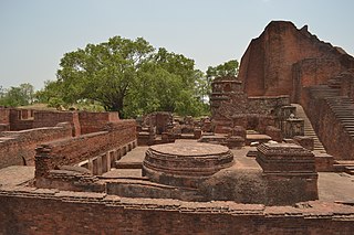
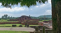
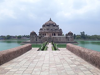
Nalanda district is one of the thirty-eight districts of the state of Bihar in India. Bihar Sharif is the administrative headquarters of this district. The districts is home to the ancient Nalanda Mahavihara a UNESCO World Heritage Site. Nalanda is located in the Magadh region of southern Bihar.

Muzaffarpur District is one of the thirty-eight districts of Bihar state, India. Muzaffarpur district is part of and also the headquarters of Tirhut Division Tirhut is the ancient name of all of northern Bihar.

Lakhisarai district is one of the thirty-eight districts of Bihar state, India, and Lakhisarai town is the administrative headquarters of this district. Lakhisarai district is a part of Munger Division. The district occupies an area of 1,228 km2 (474 sq mi).

Jamtara district is one of the twenty-four districts of Jharkhand state in eastern India. Jamtara town is the administrative headquarters of this district. The district is situated between 23°10′ and 24°05′ north latitudes and 86°30′ and 87°15′ east longitudes.

Chandauli district is a district of Uttar Pradesh state of India, and Chandauli town is the district headquarters. Chandauli district, a part of Varanasi Division, became a separate district on 20 May 1997.
Rohtas District is one of the thirty-eight districts of Bihar state, India. It came into existence when Shahabad District was bifurcated into Bhojpur & Rohtas in 1972. Administrative headquarter of the district is Sasaram. Rohtas district has the highest literacy in Bihar. The literacy rate of Rohtas district which is 73.37% as per 2011 census is highest among all 38 districts of Bihar.
Bhagalpur division is one of the nine administrative units of Bihar, a state in the east of India. Bhagalpur city is the headquarters of the division. Established in 1765, it is oldest division of the state.

Banka is one of the thirty-eight districts of the state of Bihar in India. The district headquarters of Banka is situated in Banka town. The district was established on 21 February 1991.

Kahalgaon is a municipality town and one of 3 sub-divisions of Bhagalpur District in the state of Bihar, India. It is located close to the Vikramashila, that was once a famous centre of Buddhist learning across the world, along with Nalanda, during the Pala dynasty. The Kahalgaon Super Thermal Power Plant (KhSTPP) is located near the town (3 km). Kahalgaon was capital (capital-in-exile) of Jaunpur Sultanate (1494-1505).

Bhagalpur, historically known as Champa Nagri, is a city in the Indian state of Bihar, situated on the southern bank of the Ganges river. It is the third largest city of Bihar by population and also serves the headquarters of Bhagalpur district, Bhagalpur division, and Eastern Range. It is known as the Silk City and also listed for development under the Smart Cities Mission by Government of India. It is the only district in Bihar after capital city Patna where three major higher educational institutions IIIT Bhagalpur, Jawaharlal Nehru Medical College, TMBU, and Agriculture University (BAU) are located and also Vikramshila Central University is under construction next to the ruins of the medieval Vikramshila Mahavihara. Bhagalpur Railway Station serves the city. The river around city is home to the Gangetic dolphin, the National Aquatic Animal of India, and the Vikramshila Gangetic Dolphin Sanctuary is established near the town. The city holds the largest Manasa Puja and one of the largest processions in Kali Puja, an intangible cultural heritage of the region.

Tilka Majhi Bhagalpur University, formerly Bhagalpur University, is a public university in Bhagalpur, Bihar, India. It was established on 12 July 1960, having local colleges initially associated with Patna University. Its campus is around 264 acres (1.07 km2) in area. The name was changed from Bhagalpur University to Tilka Manjhi Bhagalpur University in 1991 in commemoration of Tilka Majhi, a freedom fighter.

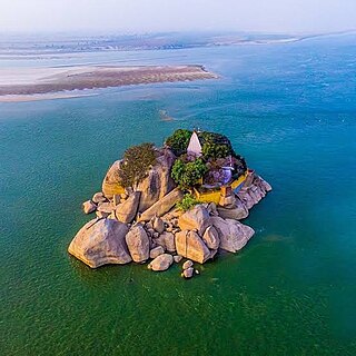
Vikramshila Gangetic Dolphin Sanctuary is located in Bhagalpur District of Bihar, India. The sanctuary is a 60 kilometers stretch of the Ganges River from Sultanganj to Kahalgaon in Bhagalpur district. notified as Vikramshila Gangetic Dolphin Sanctuary in 1991, it is the protected area for the endangered Gangetic dolphins in Asia. Once found in abundance, only a few hundred remain, of which half are found here.

Shivnarayanpur or Mathurapur is a small town in the Kahalgaon block and under Pirpainti Vidhansabha seat of Bhagalpur district of Bihar, India.
Pirpainti is a town and a notified area in Bhagalpur district in the Indian state of Bihar. It is a block of the Bhagalpur district and also a vidhansabha.