Nongpoh is the administrative centre of Ri-Bhoi district in the Indian state of Meghalaya. Nongpoh is located on National Highway 40, fifty-two kilometers from the state capital Shillong and forty-eight kilometers from Guwahati in the state of Assam.

Bhagalpur district is one of the thirty-eight districts of Bihar state, India. Bhagalpur is the oldest district of Bihar. Bhagalpur city is the administrative headquarters of this district.
Malur is a town and taluk headquarters in Kolar district of the Indian state of Karnataka. It is 30 km from Kolar, the district headquarters, and about 50 km from Bangalore. It is accessible from Bangalore by road and railways. The Chennai Central-Bangalore City line passes through Malur, with trains to various parts of India, including Tirupati, Chennai, Kochi, Trivandrum, Patna and Calcutta.
Alwarkurichi is a panchayat town in Tenkasi district in the state of Tamil Nadu, India.
Chandla is a town and a nagar parishad,Chandla Assembly constituency in Chhatarpur district in the state of Madhya Pradesh, India.

Kahalgaon is a municipality Town and one of 3 sub-divisions of Bhagalpur district in the state of Bihar, India. It is located close to the Vikramashila, that was once a famous centre of Buddhist learning across the world, along with Nalanda, during the Pala dynasty. The Kahalgaon Super Thermal Power Plant (KhSTPP) is located near the town (3 km).Kahalgaon Was Capital (capital-in-exile) Of Jaunpur Sultanate (1494-1505).
Lingiyadih is a census town in Bilaspur district in the Indian state of Chhattisgarh.

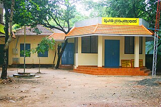
Muhamma is a census town in Cherthala Taluk in Alappuzha district in the Indian state of Kerala. It is home to Cheerappanchira kalari, where Lord Ayyappa of Sabarimala had his training in the martial arts. Cheerappanchira is an Ezhava ancestral home in Muhamma. Muhamma was the village where the Communist Party of India (Marxist) leader P. Krishna Pillai died after sustaining a snake-bite. Pathiramanal island, one of the scenic spots in vembanad lake is a part of Muhamma Panchyath.Muhamma boat jetty offers ferry services to Kumarakom and Alappuzha. Pathiramnal island can be accessed by private owned boats and also by government operated water transport.
North Vanlaiphai is a census town in East Lungdar Taluk in the Indian state of Mizoram. In the 2001 census it was listed in Serchhip District; however in the 2011 census it was listed in Champhai District.
Neelangarai is a census town and is a locality in the south of Chennai. it is situated in Chennai district in the Indian state of Tamil Nadu about seven kilometers south of Adyar, Chennai. The former name of the city was Thiruneelakandapuram, named after the Thiruneelakandeshwarar temple. Neelankarai is located with Palavakkam in the north, Vettuvankeni in the south, Thoraipakkam in the west and the Bay of Bengal in the east. Over the years Neelankarai has developed tremendously and has made a significant name for itself in popularity for various reasons.

Neem Ka Thana is a city and administrative headquarter of Neem Ka Thana district located 73 km from Sikar City in the Dhundhar region in the Rajasthan state of India. Sikar, Khandela, Sri Madhopur, Kotputli, Khetri, and Narnaul are some major cities and towns near Neem Ka Thana. It is located at a distance of 119 kilometers from Jaipur and 241 kilometers from Delhi. Neem Ka Thana is well connected with others cities in the region with roads and Indian Railways.
Pandamangalam, a panchayat town in Namakkal district, Tamil Nadu is at a distance of about three kilometers from Velur, a Small town in Paramathi-Velur Taluk.
Papparapatti is a panchayat town in Dharmapuri district in the Indian state of Tamil Nadu. The original name of this town was Pallur Pettai, later it was officially renamed as Papparapatti by the local government.
Polur is a scenic town and a Religious site for Lord Narasimha called Sampathgiri, divisional headquarters and a market center in Tiruvannamalai district of Tamil Nadu in India. Located at the foothills of Javvadhi hills, a popular section of Eastern Ghats, Polur is often regarded as Gateway of Eastern ghats. Polur was once an eminent center of Tamil Jainism. The town is home to Dharani sugars, chemicals and fertiliser Pvt., Ltd, and number of agro based industries including coir industries. The famous Chittoor - Cuddalore road passes through the town. The town is located 29 Kilometres north of city of Tiruvannamalai and 45 kilometres south of Vellore Metropolis.
Sayalgudi is a town panchayat in Ramanathapuram district of Tamil Nadu State in India. It is located west of the district along the East Coast Highway towards Kanyakumari. The state highway SH200 passes through the town connecting districts of Thoothukudi and Tirunelveli. It surrounded by many small villages and acts as marketplace for people.
Mangalam is a census town in Tiruppur district in the Indian state of Tamil Nadu.
Koodali is a census town and grama panchayat in Thalassery taluk of Kannur district in Kerala state, India. Koodali is located 15.5 km (9.6 mi) east of Kannur city on Kannur-Mattanur road.
Vazhakala is a neighbourhood region in the city of Kochi in Kerala, India. It is situated around 5 km (3 mi) from the city center and is part of Thrikkakkara Municipality. It can be classified as a typical residential area adjacent to schools, colleges and professional institutions.it has a history about 150 years mainly associated with age old churches and temples.
Pirpainti is a town and a notified area in Bhagalpur district in the Indian state of Bihar. It is a block of the Bhagalpur district and also a vidhansabha.
Nandgola is a village located in the Kahalgaon block of Bhagalpur district in Bihar, India. It is situated 12 km away from the town of Kahalgaon and 42 km away from the district headquarter Bhagalpur. The village located near to Vikramashila and Bateshwar hills. Nandgola is part of a Antichak village panchayat.


