
Deoghar is a city and a municipal corporation in Deoghar district in the Indian state of Jharkhand. It is also the administrative headquarters of Deoghar district. It is a holy place of Hinduism. The city is primarily known for Baidyanath Temple, one of the 12 Jyotirlingas of Shiva, one of the principal deities in Hinduism. The sacred temples of the city make this a place for pilgrimage and tourists. The city is very sacred to the followers of Hinduism.
Jamui is a town and a municipality in Jamui district in the Indian state of Bihar. It is the district headquarter of Jamui district. Jamui was formed as a district on 21 February 1991 as a result of its separation from Munger. It is part of Munger Division. The town is situated about 60km South-West of Munger.

Madhepura district is one of the thirty-eight districts of Bihar state, India, and Madhepura town is the administrative headquarters of this district. Madhepura district is a part of Kosi division.

Katihar district is one of the thirty-eight districts of Bihar state in India, and Katihar city is the administrative headquarters of this district. The district is a part of Purnia Division. It is prominently known for its Katihar Junction Railway Station, which is a Category A1 station on the Barauni–Guwahati line. It has been included in the Aspirational Districts Program of the Government of India since 2018, to improve its socio-economic indicators.

Bhagalpur district is one of the thirty-eight districts of Bihar state, India. Bhagalpur is the oldest district of Bihar. Bhagalpur city is the administrative headquarters of this district.

Kahalgaon is a municipality Town and one of 3 sub-divisions of Bhagalpur district in the state of Bihar, India. It is located close to the Vikramashila, that was once a famous centre of Buddhist learning across the world, along with Nalanda, during the Pala dynasty. The Kahalgaon Super Thermal Power Plant (KhSTPP) is located near the town (3 km).Kahalgaon Was Capital (capital-in-exile) Of Jaunpur Sultanate (1494-1505).
Bihpur is a block in Bhagalpur district of Bihar, India. It is one of sixteen blocks under Bhagalpur district. According to Census 2011, the sub-district code of Bihpur Block (CD) is 01330.It lies in the Anga Region of Bihar.
Mandro is a community development block that forms an administrative division in the Sahibganj subdivision of the Sahibganj district, Jharkhand state, India.
Hansdiha is a village in the Saraiyahat CD block which is an administrative division in the Dumka Sadar subdivision of the Dumka district, Jharkhand state of India.
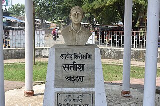
Kharhara is a small town in Banka district in the state of Bihar, India. It is the birthplace of Satish Chandra Jha, one of seven martyrs Shaheed Smarak Patna who hoisted the flag of India at Patna Secretariat during 1942 Quit India Movement.
Dhad is a gram panchayat village in Buldana Taluka in Buldhana District of Maharashtra State, India. It belongs to Vidarbha region. It belongs to Amravati Division. It is located 29 km towards west from District headquarters Buldhana. 17 km from Buldana. 424 km from State capital Mumbai.
Kharik is a village and the administrative center of Kharik Block, Bhagalpur District, Bihar, India. It is located on the northern part of the district, approximately 14 kilometres north of the district capital Bhagalpur. In 2011, It has 42,354 inhabitants.
Shankarpur Khawas is a village in Colgong Block, Bhagalpur District, Bihar, India. It is situated near the state border with Jharkhand, about 16 kilometres east of the district seat of Bhagalpur, and 12 kilometres southwest of the block seat of Kahalgaon. In 2011, it had a population of 38,852.
Saidpur Dabra is a village in Gopalpur Block, Bhagalpur District, Bihar, India. It is located near the state boundary with Jharkhand, about 21 kilometres northeast of the district seat Bhagalpur, and 19 kilometres northeast of the block seat Gopalpur. In the year 2011, it has a total population of 37,101.
Kaharpur is a village located in the Bihpur block of Bhagalpur district in Bihar, India. It is situated 5 km away from sub-district headquarter Bihpur and 37 km away from district headquarter Bhagalpur.
Nandgola is a village located in the Kahalgaon block of Bhagalpur district in Bihar, India. It is situated 12 km away from the town of Kahalgaon and 42 km away from the district headquarter Bhagalpur. The village located near to Vikramashila and Bateshwar hills. Nandgola is part of a Antichak village panchayat.
Partapnagar is a village in Naugachhia Block, Bhagalpur District, Bihar, India. It is located on the north of Bhagalpur District, about 20 kilometres northeast of the district capital Bhagalpur, and 2 kilometres northwest of the block capital Naugachhia. In the year 2011, it had a population of 35,878.
Khawaspur Diara urf Topra is a large village in Bihar, India, near the northern edge of Bhagalpur District. The village is located approximately 40 kilometres northeast of the district seat Bhagalpur, and is surrounded by the settlements of Nandi Gobind urf Chulia, Khawaspur Milik and Sangalbahita. In the 2011 census, it had a population of 35,545.
Akbarnagar is a town in the Sultanganj block of Bhagalpur district in Bihar, India. It is situated on the southern part of the district, about 14 kilometres west of the district headquarter Bhagalpur. In the year 2011, the town had a population of 12000.

