Magadh division

Last updated

Magadh division
Division of Bihar
Magadh division.svg
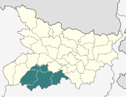
Location of Magadh division in Bihar
Coordinates: 24°45′N85°00′E / 24.750°N 85.000°E / 24.750; 85.000 Coordinates: 24°45′N85°00′E / 24.750°N 85.000°E / 24.750; 85.000
CountryFlag of India.svg  India
State Bihar
Headquarters Gaya
Districts Gaya, Nawada, Aurangabad, Jehanabad, Arwal
Government
  CommissionerMayank Warwade, IAS [1]
Population
 (2011)
  Total10,931,018

Magadh division is an administrative geographical unit of Bihar state of India. Gaya is the administrative headquarters of the division. Currently (2005), the division consists Gaya district, Nawada district, Aurangabad district, Jehanabad district, and Arwal district. The current divisional commissioner is Mayank Warwade, an IAS officer of 2001 batch of Bihar cadre. [2] Magadh is home to the Magahi culture. People speak Magahi language here.

Contents

Districts, Sub-divisions, and Blocks

Magadh Division
(HQ: Gaya)
5 District, 10 Subdivisions, and 61 Blocks
#DistrictHeadquarterSubdivisions#BlocksRef
1 Gaya Gaya Sadar
Sherghati
Tekari
Nimchak Bathani
24 [3]
2 Aurangabad Aurangabad Auranagabad
Daudnagar
11 [4]
3 Nawada Nawada Nawada
Rajauli
14 [5]
4 Jehanabad Jehanabad Jehanabad7 [6]
5 Arwal Arwal Arwal5 [7]

See also

Related Research Articles

<span class="mw-page-title-main">Magahi language</span> Indo-Aryan language spoken in India

The Magahi language, also known as Magadhi, is a language spoken in Bihar, Jharkhand and West Bengal states of eastern India, and in the Terai of Nepal. Magadhi Prakrit was the ancestor of Magahi, from which the latter's name derives.

<span class="mw-page-title-main">Gaya (India)</span> City in Bihar, India

Gaya is a city, municipal corporation and the administrative headquarters of Gaya district and Magadh division of the Indian state of Bihar. Gaya is 116 kilometres (72 mi) south of Patna and is the state's second-largest city, with a population of 470,839. The city is surrounded on three sides by small, rocky hills, with the Phalgu River on its eastern side.

<span class="mw-page-title-main">Nawada</span> City in Bihar, India

Nawada is a city and a municipality in Bihar, India. It is also the headquarters of the Nawada district. It is the headquarters of the subdivision of the same name, lying on both sides of the Khuri River( also known as Sakri river in some parts) at 24º 53’ N and 85º 33’ E. The name evolved from Nau-wada, meaning the new town. On 26 January 1973, Nawada was formed as a separate district from Gaya.

<span class="mw-page-title-main">Magadh University</span> University in Bihar, India

Magadh University is a public state university and institution of higher education in Bodhgaya, Bihar, India. It is recognised by the University Grants Commission (UGC).

<span class="mw-page-title-main">Nawada district</span> District of Bihar in India

Nawada district is one of the thirty-eight districts of the Indian state of Bihar. Nawada is its administrative headquarters. The district is the easternmost district of the Magadh division, one of the nine administrative divisions of Bihar. The area of the modern district was historically part of the Magadha, Shunga and Gupta empires. Koderma and Giridih districts of the state of Jharkhand lie on the southern border of the district; it also shares borders with the Gaya, Nalanda, Sheikhpura, and Jamui districts of Bihar.

<span class="mw-page-title-main">Arwal district</span> District of Bihar in India

Arwal district is one of the thirty-eight districts of Bihar state, India, and Arwal town is the administrative headquarters of this district. It was earlier part of Jehanabad district.

<span class="mw-page-title-main">Aurangabad district, Bihar</span> District of Bihar in India

Aurangabad district is one of the thirty-eight districts of Bihar state, India. It is currently a part of the Red Corridor.

<span class="mw-page-title-main">Jehanabad district</span> District of Bihar in India

Jehanabad district is one of the thirty-eight districts of Bihar state, India. Jehanabad town is the administrative headquarters of this district. Jehanabad district is a part of Magadh Division, and is located on the confluence of two small rivers called Dardha and Yamunaiya.

Aurangabadpronunciation  is a city in Aurangabad District, Bihar, India. It is the district's centre of governance and has a population of 102,244 as of 2011. The people of this region speak Magahi and Hindi.

<span class="mw-page-title-main">Gaya district</span> District of Bihar in India

Gaya district is one of the thirty-eight districts of the Indian state of Bihar. It was officially established on 3 October 1865. The district has a common boundary with the state of Jharkhand to the south. Gaya city is both the district headquarters and the second-largest city in Bihar.

Konch is a community development block of Gaya district in Bihar, India. Konch(Konch Village/Konch Panchayat/Konch Thana-Police Station) is a typical village market area slowly taking shape of a sub-urban settlement and centre of small business. Konch has very important temple known as Koncheswar Mahadev belonging to the later Gupta period which now has been taken under the protection of Archaeological Survey of India (ASI).

Khatangi is a prominent village in Bihar, India. It is situated in Sonbhadra-Bansi-Surajpur Block in Arwal district of the State of Bihar. It is located at 96.1 km distance from Arwal and at 114 km distance from the state capital Patna. It is a very old village with a population of about 5,000 people. The literacy rate is 45.56%, comprising a female literacy rate of 27.3% and a male literacy rate of 62.98%. The people here are very friendly and hospitable. The economy of this village is agro-based and agriculture remains the main source of income.

<span class="mw-page-title-main">Arwal</span> Town in Bihar, India

Arwal town is the administrative headquarters of Arwal district in Bihar state of India. It was earlier part of Jehanabad district. The district as formed to control the naxalism in the area. District was formed from the area of two near by districts i.e. Jehanabad and Aurangabad. Arwal has a population of 588,000. Arwal, the district headquarters is approximately 80 km south from the state capital Patna. Arwal town is situated on the right side bank of the Sone River, which is a tributary to the Ganges.

Most of the languages of Bihar, the third most populous state of India, belong to the Bihari subgroup of the Indo-Aryan family. Chief among them are Bhojpuri, spoken in the west of the state, Maithili in the north, and Magahi in the south. Of these, only Maithili has official recognition under the Eighth Schedule to the Constitution of India. The official language of Bihar is Hindi, with Urdu serving as a second official language in 15 districts.

<span class="mw-page-title-main">Bihar Police</span> Police Service of Bihar

The Bihar Police Department is the law enforcement agency for the state of Bihar, India, with its headquarters in Patna. It has a sanctioned strength of 111,000 personnel, and as of 2017, employs 77,000 personnel. The annual Budgeted Estimate (BE) for Bihar Police for the year 2020-21 is 10,021 crore (US$1.3 billion), of which 145 crore (US$18 million) has been allocated to Police Modernization.

ShaharTelpa Panchayat is a village in Karpi Block in Arwal District in the Indian state of Bihar. It belongs to the Magadh Division. It is located 14 km south from the District headquarters in Arwal. It is 9 km from Karpi and 83 km from the state capital Patna.

<span class="mw-page-title-main">Magahi culture</span>

The culture of Magadh is rich with its distinct language, folk songs and festivals. In ancient period it was known as Magadha mahajanpada. The present-day Magadh region split between the states of Bihar and Jharkhand, India. The major language of the region is Magahi.

Shamshernagar is a large village in the Daudnagar subdivision and block in Aurangabad district, located in Bihar, India. The town falls under the jurisdiction of the Magadh division. Situated on the bank of the Sone River, the National Highway 139 passes through the village. The Indrapuri Barrage canal is a local waterway. Shamshernagar is densely populated. It has adequate infrastructure, including a middle school, an intermediate high school, an additional Primary Health Centre, and a Regional Rural Bank (MBGB). Shamshernagar is an electrified village. and possesses a water tank for its water supply. It shares a border between Aurangabad and Arwal districts. Buses, auto-rickshaws and e-rickshaws provide regional transportation.

Raja Jagannath Prasad Singh Kinkar was an Indian ruler of Deo Raj, a princely estate in present day Aurangabad district of Bihar. He was noted for producing Bihar's first film, Chhat Mela, in 1930. It was a silent documentary film on the Chhath festival of Deo.

References