Begusarai district

Last updated

Begusarai district
Begusarai district skyline.jpg
From top left to right: Naulakha Temple;NTPC, Barauni  ;Rajendra Setu; Barauni Refinery;HURL, Barauni Fertilizer
Bihar district location map Begusarai.svg
Location of Begusarai district in Bihar
Coordinates(Begusarai): 25°25′00″N86°08′00″E / 25.4167°N 86.1333°E / 25.4167; 86.1333
CountryIndia
State Bihar
Region Mithila
Division Munger
Established1870
District2 October 1972
Headquarters Begusarai
Government
   District Magistrate Roshan Kushwaha [1]
   MP, Begusarai Lok Sabha Giriraj Singh
Area
  Total1,918 km2 (741 sq mi)
Population
 (2011)
  Total2,970,541
  Density1,500/km2 (4,000/sq mi)
Demographics
   Literacy 63.87 per cent
  Sex ratio894
Language
  Official Hindi [2]
  Additional official Urdu [2]
  Other recognised Maithili [3]
Time zone UTC+05:30 (IST)
Vehicle registration BR-09
Major highways NH 31, NH 28
Average annual precipitation1384 mm
Website begusarai.nic.in

Begusarai District is one of the thirty-eight districts of the Indian state of Bihar. The city of Begusarai is its administrative headquarters and is part of the Munger division.

Contents

History

Begusarai was established in 1870 as part of Munger District. In 1972, it was given district status. [4]

Geography

Begusarai district occupies an area of 1,918 square kilometres (741 sq mi). [5] The district lies on the northern bank of the river Ganges. Begusarai district is a part of Munger division. It is located at latitudes 25.15N & 25.45N and longitudes 85.45E & 86.36E. The Ganges river separates Begusarai district from Patna District and Munger District.[ citation needed ]

Flora and fauna

Kanwar Lake Kanwar Lake Begusarai by Ziddi Photowala.jpg
Kanwar Lake

In 1989 Begusarai district became home to the Kanwar Lake Bird Sanctuary Kanwar Lake Bird Sanctuary Wildlife Sanctuary, which has an area of 63 km2 (24.3 sq mi). [6] It is Asia's largest freshwater oxbow lake. In November 2020, the Ministry of Environment, Forest and Climate Change (MoEFCC) declared it the first Ramsar site in Bihar.[ citation needed ]

Demographics

Historical population
YearPop.±% p.a.
1901575,455    
1911593,470+0.31%
1921564,328−0.50%
1931635,456+1.19%
1941718,390+1.23%
1951793,942+1.00%
1961954,333+1.86%
19711,147,429+1.86%
19811,456,343+2.41%
19911,814,773+2.22%
20012,349,366+2.62%
20112,970,541+2.37%
source: [7]
Religions in Begusarai district (2011) [8]
ReligionPercent
Hinduism
85.99%
Islam
13.71%
Other or not stated
0.30%

According to the 2011 census Begusarai district has a population of 2,970,541, [9] roughly equal to the nation of Armenia [10] or the US state of Mississippi. [11] This gives it a ranking of 128th in India (out of a total of 640). [9] The district has a population density of 1,540 inhabitants per square kilometre (4,000/sq mi). [9] Its population growth rate over the decade 2001-2011 was 26.44%. [9] Begusarai has a sex ratio of 895 females for every 1000 males, [9] and a literacy rate of 63.87%. 19.18% of the population lives in urban areas. Scheduled Castes and Scheduled Tribes make up 14.55% and 0.05% of the population respectively. [9]

Languages of Begusarai district (2011) [12]

   Hindi (79.77%)
   Urdu (9.53%)
  'Other' Hindi (7.94%)
   Maithili (2.43%)
  Others (0.33%)

At the time of the 2011 Census of India, 79.77% of the population in the district spoke Hindi, 9.53% Urdu and 2.43% Maithili as their first language. 7.94% of the population spoke 'Others' under Hindi. [12]

Politics

DistrictNo.ConstituencyNamePartyAllianceRemarks
Begusarai 141 Cheria-Bariarpur Raj Banshi Mahto RJD MGB
142 Bachhwara Surendra Mehata BJP NDA
143 Teghra Ram Ratan Singh CPI MGB
144 Matihani Raj Kumar Singh JD(U) NDA Switched from LJP to JD(U) [13]
145 Sahebpur Kamal Sadanand Yadav RJD MGB
146 Begusarai Kundan Kumar BJP NDA
147 Bakhri Suryakant Paswan CPI MGB

Current Member of Legislative council Bihar Vidhan Parishad (Begusarai-Khagaria)

S.no.NamePartyAlliance
1.Rajiv Kumar Indian National Congress MGB

Administration

Kanwar Lake Begusarai -A Ramsar Convention Site wetland Kanwar Lake Begusarai by Ziddi Photowala.jpg
Kanwar Lake Begusarai -A Ramsar Convention Site wetland

Subdivisions

Source: [14]

Cities and towns

Villages

Economy

NTPC, Barauni (Barauni Thermal Power Station) Baraunithermal.png
NTPC, Barauni (Barauni Thermal Power Station)

Barauni is the major industrial town in the district. It has big industries like Barauni Refinery, Barauni Thermal Power Station, Urvarak Nagar Barauni, Garhara locomotive shed and Pepsi bottling plant. Shri Krishna Singh wanted to build an industrial corridor from Begusarai-Bakhtiyarpur-Fatuha, so he looked to construct Rajendra Setu in Mokama. Begusarai is one of the largest milk-consuming districts in India. Sudha dairy plant is also one of the biggest exporters of milk all over Bihar. [15]

Transportation

Begusarai Railway Station Begusarai railway station.png
Begusarai Railway Station
Rajendra Setu Rajendra Setu.png
Rajendra Setu

Barauni Junction is the major railway junction. Another major railway station is Begusarai. Begusarai is well connected by road to other parts of Bihar and the country.

Railways

Barauni Junction is one of the important stations in Bihar. It is a junction and is connected to India's main cities of New Delhi, Kolkata, Mumbai and Chennai via broad gauge routes. Begusarai railway station is located in Begusarai city.

Roads

NH-31 is passing through Begusarai district. NH 31.jpg
NH-31 is passing through Begusarai district.

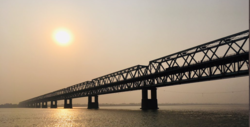
National Highway 28 starts at Barauni and leads to Lucknow. National Highway 31 passes through the district and leads to Guwahati. Both National Highways have junctions here. It is also called Assam Road. Many small city buses pass through here. Begusarai district also has Rajendra Setu on the Ganges near Simariya, which was the first railroad bridge in independent India on the river Ganges. The first six-lane bridge is under construction in Begusarai on the Ganges in Simaria. It will be complete by October 2023. [16]

Education

Rashtrakavi Ramdhari Singh Dinkar College of Engineering (RRSDCE) was laid on 22 December 2013 by Nitish Kumar, paving way for the eighth government engineering college in Bihar. [17] [18] G D College is a notable undergraduate and postgraduate degree college of the district. [19]

Notable people

Ramdhari Singh Dinkar Ramdhari Singh Dinkar 1999 stamp of India.jpg
Ramdhari Singh Dinkar

Related Research Articles

<span class="mw-page-title-main">Ramdhari Singh Dinkar</span> Indian poet

Ramdhari Singh, known by his pen name Dinkar, was an Indian Hindi language poet, essayist, freedom fighter, patriot and academic. He emerged as a poet of rebellion as a consequence of his nationalist poetry written in the days before Indian independence. His poetry exuded Veer Rasa, and he has been hailed as a Rashtrakavi and Yuga-Chāraṇa on account of his inspiring patriotic compositions. He was a regular poet of Hindi Kavi Sammelan and is hailed to be as popular and connected to poetry lovers for Hindi speakers as Pushkin for Russians.

<span class="mw-page-title-main">Begusarai</span> City in Bihar, India

Begusarai is the industrial and financial capital of Bihar and the administrative headquarters of the Begusarai district, which is one of the 38 districts of the Indian state of Bihar. The district lies on the northern bank of the river Ganges in the Mithila region of India.

<span class="mw-page-title-main">Munger</span> City in Bihar, India

Munger, formerly spelt as Monghyr, is a twin city and a Municipal Corporation situated in the Indian state of Bihar. It is the administrative headquarters of Munger district and Munger Division. Munger was one of the major cities in Eastern India and undivided Bengal during Mughal period and British Raj. It is one of the major political, cultural, educational and commercial center of Bihar and Eastern India. Munger is situated about 180km from east of capital city Patna, about 480km west of Eastern India's largest city Kolkata and 1200km from country's capital New Delhi.

<span class="mw-page-title-main">East Central Railway zone</span> Indian railway zone

The East Central Railway is one of the 19 railway zones in India. It is headquartered at Hajipur and comprises Sonpur, Samastipur, Danapur, Pt. Deen Dayal Upadhyaya, and Dhanbad divisions.

<span class="mw-page-title-main">Patna district</span> District in Bihar, India

Patna district is one of the thirty-eight districts of Bihar state in eastern India. Patna, the capital of Bihar, is the district headquarters. The Patna district is a part of Patna division. The Patna district is divided into 6 Sub-divisions (Tehsils) i.e. Patna Sadar, Patna City, Barh, Masaurhi, Danapur and Paliganj.

<span class="mw-page-title-main">Khagaria district</span> District of Bihar in India

Khagaria district is an administrative district in Mithila region in the state of Bihar in India. The district headquarters are located at Khagaria. Earlier it was a part of Munger District as a sub-division that was created in 1943–44. It was upgraded to the status of a district on 10 May 1981. Khagaria district is a part of Munger Division.

<span class="mw-page-title-main">Munger district</span> District of Bihar in India

Munger district is one of the thirty-eight districts of Bihar state in eastern India. The city of Munger is the administrative headquarters of this district. The district is a part of Munger Division. Its literacy rate of 73.3% is higher than the state literacy rate of 63.8%, but lower than national rate of 74.04%.

<span class="mw-page-title-main">Shri Krishna Sinha</span> Indian Statesman

Shri Krishna Singh (Sinha) (21 October 1887 – 31 January 1961), also known as Shri Babu, was the first chief minister of the Indian state of Bihar (1946–61). Except for the period of World War II, Sinha was the chief minister of Bihar from the time of the first Congress Ministry in 1937 until his death in 1961. Along with the Desh Ratna Rajendra Prasad and Bihar Vibhuti Anugrah Narayan Sinha (A.N. Sinha), Sinha is regarded among the 'Architects of Modern Bihar'. He also led the Dalit entry into the Baidyanath Dham temple (Vaidyanath Temple, Deoghar). He was the first chief minister in the country to abolish the zamindari system. He underwent terms of imprisonment for a total of about eight years in British India. Sinha's mass meetings brought many people to hear him. He was known as Bihar Kesari for his "lionlike roars" in public speaking. His close friend and Gandhian Bihar Vibhuti A.N. Sinha in his essay Mere Shri Babu wrote that, "Since 1921, the History of Bihar has been the history of the life of Shri Babu".

<span class="mw-page-title-main">Dalsinghsarai</span> City in Bihar, India

Dalsinghsarai is a city and Municipal Council in the Samastipur District of Bihar, India. It is also one of the subdivisions and blocks of Bihar. It is situated on the bank of the river Balan.

<span class="mw-page-title-main">Barauni</span> Town in Bihar, India

Barauni is an industrial town situated on the bank of the river Ganges in the Begusarai district in the state of Bihar, India. It lies north of the Ganges (Ganga) River.

<span class="mw-page-title-main">Surajbhan Singh</span> Indian politician

Surajbhan Singh is an Indian politician and former Member of Parliament. He was elected to the Lok Sabha from Bihar contesting on a ticket from Lok Janshakti Party (LJP). Currently he is debarred from contesting due to conviction in the Brij Behari Prasad murder case.

<span class="mw-page-title-main">Rajendra Setu</span> Rail-cum-road bridge in Bihar, India

Rajendra Setu, or Simaria Bridge, is a bridge across the Ganges that was the first to link the northern and southern portions of the state of Bihar. The location of the bridge was based on the work of M. Visvesvaraya, who was more than 90 years old at the time. In a wheelchair, he visited the bridge site on the special request of Bihar's chief minister, Shri Krishna Sinha. It was the first bridge over the Ganges to be built in independent India.

<span class="mw-page-title-main">Munger Ganga Bridge</span> Bridge in Bihar India

Shri Krishna Setu NH 333B is a rail-cum-road bridge across the Ganges, at Munger in the Indian state of Bihar and named after first Chief Minister of Bihar Shri Krishna Singh. The bridge connects the Munger-Jamalpur twin cities in Munger District to various districts of North Bihar. Srikrishna Setu Munger Ganga Bridge is the third rail-cum-road bridge over Ganga in Bihar.

<span class="mw-page-title-main">Teghra Assembly constituency</span> Vidhan Sabha constituency

Teghra is an assembly constituency in Begusarai district in the Indian state of Bihar. It was earlier called Barauni Assembly constituency.

<span class="mw-page-title-main">Matihani Assembly constituency</span> Vidhan Sabha constituency

Matihani Assembly constituency is an assembly constituency in Begusarai district in the Indian state of Bihar.

Barauni was an assembly constituency in Begusarai district in the Indian state of Bihar.

<span class="mw-page-title-main">Mokama–Barauni section</span> Railway line in India

The Mokama–Barauni section connects Mokama Junction and Barauni Junction in the Indian state of Bihar.

<span class="mw-page-title-main">Simaria</span> Village in Bihar state in India

Simaria is a village in India, along the Ganges river. It is in Begusarai District, Mithila region of India and near Barauni. Also called Kumbhasthali, Amritbhumi, Welcome Gate of Mithila ,Known for the birthplace of Hindi poet Ramdhari Singh 'Dinkar', then part of Bengal Presidency, British India, now in Begusarai District, Mithila region of Bihar. Situated on the South Eastern boundary of Begusarai, It is also famous for Simaria Mela, a fair of devotional importance during the month of Kartik every year according to Indian Panchang. It has a famous bridge, the iconic Rajendra Setu providing both Rail and Road connectivity to this place. People of Simaria widely speak Maithili language.

The state of Bihar has a number of bridges, extending from few metres to a few kilometres. The history of long bridges goes back to the British Empire when the site for the Koilwar bridge was surveyed in 1851. Since then a number of small and large bridges have crept up. Some are even largest of their kind. Mahatma Gandhi Setu, joining Patna and Hajipur was India's longest river bridge from 1982 to 2017.

<span class="mw-page-title-main">Begusarai railway station</span> Railway station in Bihar

Begusarai railway station is a railway station in the Sonpur division of East Central Railway. Begusarai is better known as the Industrial Capital of Bihar, the birthplace of noted poet Rashtrakavi Ramdhari Singh Dinkar and karmabhoomi of the Great freedom fighter, first chief minister and architect of modern Bihar Dr. Shrikrishna Sinha alias Sri Babu.

References

  1. "District website of Begusarai Contents of Begusarai District India" . Retrieved 20 September 2022.
  2. 1 2 "52nd Report of the Commissioner for Linguistic Minorities in India" (PDF). nclm.nic.in. Ministry of Minority Affairs. Archived from the original (PDF) on 25 May 2017. Retrieved 9 August 2020.
  3. "Archived copy" (PDF). Archived from the original (PDF) on 5 March 2016. Retrieved 28 May 2016.{{cite web}}: CS1 maint: archived copy as title (link)
  4. Law, Gwillim (25 September 2011). "Districts of India". Statoids. Retrieved 11 October 2011.
  5. Srivastava, Dayawanti (2010). "States and Union Territories: Bihar: Government". India 2010: A Reference Annual (54th ed.). New Delhi, India: Additional Director General, Publications Division, Ministry of Information and Broadcasting (India), Government of India. pp. 1118–1119. ISBN   978-81-230-1617-7.
  6. Indian Ministry of Forests and Environment. "Protected areas: Bihar". Archived from the original on 23 August 2011. Retrieved 25 September 2011.
  7. "Table A-02 Decadal Variation in Population Since 1901: Bihar" (PDF). census.gov.in. Registrar General and Census Commissioner of India.
  8. "Table C-01 Population by Religion: Bihar". censusindia.gov.in. Registrar General and Census Commissioner of India. 2011.
  9. 1 2 3 4 5 6 "District Census Handbook: Begusarai" (PDF). Census of India . Registrar General and Census Commissioner of India. 2011.
  10. US Directorate of Intelligence. "Country Comparison:Population". Archived from the original on 13 June 2007. Retrieved 1 October 2011. Armenia 2,967,975 July 2011 est.
  11. "2010 Resident Population Data". U. S. Census Bureau. Archived from the original on 19 October 2013. Retrieved 30 September 2011. Mississippi 2,967,297
  12. 1 2 "Table C-16 Population by Mother Tongue: Bihar". censusindia.gov.in. Registrar General and Census Commissioner of India. 2011.
  13. "Lone Lok Janshakti Party MLA Raj Kumar Singh joins JD(U) in Bihar". Hindustan Times. 7 April 2021. Retrieved 27 February 2022.
  14. "Subdivision & Blocks | District website of Begusarai | India" . Retrieved 22 May 2023.
  15. Kumar, Rajiv (25 April 2014). "Making of Begusarai was by choice, not accident - Times of India". The Times of India. Retrieved 14 February 2020.
  16. Asia's Widest Bridge | Drone View | Mokama Waterlifting | Auntaghat Simaria 6 Lane Bridge | TheWay4U , retrieved 23 June 2022
  17. Kumar, Rajiv (23 December 2013). "CM lays foundation of engineering college". Times of India. Retrieved 23 December 2013.
  18. "Nitish lists special tag cry as LS poll plank". The Telegraph. 23 December 2013. Archived from the original on 24 December 2013. Retrieved 23 December 2013.
  19. "IGNOU Study Centre GD College Begusarai Admission 2022". IGNOU University. 15 January 2022. Retrieved 4 May 2022.

Further reading