List of monuments of national importance
| SL. No. | Description | Location | Address | District | Coordinates | Image |
|---|---|---|---|---|---|---|
| N-BR-1 | Tomb of Shamsher Khan | Shamshernagar | Aurangabad | 25°05′26″N84°27′34″E / 25.09045°N 84.45948°E |  More images | |
| N-BR-2 | Vikramashila monastic university | Antichak | Bhagalpur | 25°19′26″N87°17′05″E / 25.32399°N 87.28473°E |  More images | |
| N-BR-3 | Rock Temple | Kahalgaon | Bhagalpur | 25°15′47″N87°13′17″E / 25.26303°N 87.22136°E |  More images | |
| N-BR-4 | Patalpuri cave and land adjoining Bateshwar Sthan cave on the Patharghata hill | Madhorampur | Bhagalpur | 25°19′44″N87°15′38″E / 25.32902°N 87.26056°E |  More images | |
| N-BR-5 | Rock sculptures | Patharghatta Hill, Madhorampur | Bhagalpur | 25°19′41″N87°15′38″E / 25.32797°N 87.2605°E |  More images | |
| N-BR-6 | Ancient mound | Buxar | Buxar |  Upload Photo | ||
| N-BR-7 | Ashoka column known as Laur pillar | Lauriya Araraj | East Champaran | 26°33′01″N84°38′51″E / 26.55024°N 84.64759°E |  More images | |
| N-BR-8 | Fort ruins, tank and Stupa | Sagardih | East Champaran | 26°27′32″N84°57′35″E / 26.459°N 84.95974°E |  More images | |
| N-BR-9 | Kesaria Stupa | Tajpur Deur | East Champaran | 26°20′03″N84°51′18″E / 26.33419°N 84.85492°E |  More images | |
| N-BR-10 | Sujata Stupa | Bakraur | Gaya | 24°41′53″N85°00′12″E / 24.69798°N 85.00332°E | 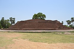 More images | |
| N-BR-11 | Ancient mounds in the valley known as “Hasra Kol” | Bishunpurtarwa, Hasra and Jagdishpur | Gaya | Upload Photo | ||
| N-BR-12 | Ancient mouds in the hill known as ‘Sobhnath’ | Bishunpurtarwa, Hasra and Jagdishpur | Gaya | Upload Photo | ||
| N-BR-13 | Ancient Buddhist and other sculptures collected in a temple | Guneri | Gaya | 24°37′06″N84°44′09″E / 24.61822°N 84.7358°E | Upload Photo | |
| N-BR-14 | Koncheswar Mahadev Shiva temple | Konch | Gaya | 24°56′01″N84°46′18″E / 24.93363°N 84.77158°E |  More images | |
| N-BR-15 | Sculptures of various Hindu deities carved on the southern and eastern faces of some rocks and boulders of Kauwadol Hill | Kurisarai | Gaya | 24°59′30″N85°01′40″E / 24.99162°N 85.02782°E |  More images | |
| N-BR-16 | Sculptures of various Hindu deities carved on the face of an isolated round boulder separated by a distance of 12 feet from the south-eastern corner of the Kauwadol Hill. | Kurisarai | Gaya | 24°59′31″N85°01′43″E / 24.9919°N 85.02853°E |  More images | |
| N-BR-17 | Sculptures of various Hindu deities carved on the northern-eastern faces of some rocks of Kauwadol Hill. | Kurisarai | Gaya | 24°59′32″N85°01′43″E / 24.99219°N 85.02854°E |  More images | |
| N-BR-18 | Sculptures of four Hindu deities one on each side of an oblong isolated boulder to the east of the Kauwadol Hill. | Kurisarai | Gaya | 24°59′33″N85°01′44″E / 24.99241°N 85.02876°E |  More images | |
| N-BR-19 | The whole of the ancient ruins on which there are a colossal statue of Buddha, a few loose sculptures and thirteen sandstone pillars. | Kurisarai | Gaya | 24°59′37″N85°01′40″E / 24.99348°N 85.02776°E |  More images | |
| N-BR-20 | The area generally known as ‘Garh’ is the site of an ancient Buddhist monasteryand chaityas, a Shiva temple and a tank. [3] | Kurkihar | Gaya | 24°49′43″N85°15′13″E / 24.82868°N 85.2537°E |  More images | |
| N-BR-21 | Gopika Cave | Nagarjuni hills | Jehanabad | 25°00′33″N85°04′42″E / 25.00904°N 85.07847°E |  More images | |
| N-BR-22 | Karan Chaupar Cave | Barabar hills | Jehanabad | 25°00′21″N85°03′47″E / 25.00593°N 85.06306°E |  More images | |
| N-BR-23 | Vadathika cave | Nagarjuni hills | Jehanabad | 25°00′41″N85°04′37″E / 25.01128°N 85.07697°E |  More images | |
| N-BR-24 | Lomas Rishi cave | Barabar hills | Jehanabad | 25°00′20″N85°03′47″E / 25.00559°N 85.06316°E | 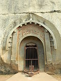 More images | |
| N-BR-25 | Sudama Cave | Barabar hills | Jehanabad | 25°00′20″N85°03′47″E / 25.00569°N 85.06297°E |  More images | |
| N-BR-26 | Vapiyaka Cave | Nagarjuni hills | Jehanabad | 25°00′40″N85°04′37″E / 25.01121°N 85.07699°E |  More images | |
| N-BR-27 | Visva Jhopa Cave | Barabar hills | Jehanabad | 25°00′20″N85°03′56″E / 25.00559°N 85.06555°E |  More images | |
| N-BR-28 | Ancient Buddhistic image and sculptures collected underneath a shed | Ghejan | Jehanabad | 25°03′58″N84°53′23″E / 25.06602°N 84.88966°E | Upload Photo | |
| N-BR-29 | Ancient monolithic pillar known as Lat | Lat | Jehanabad | 25°05′54″N85°09′37″E / 25.09836°N 85.16034°E |  More images | |
| N-BR-30 | Tomb of Bakhtiar Khan | Malik Sarai | Kaimur | 25°01′51″N83°29′18″E / 25.03087°N 83.48846°E |  More images | |
| N-BR-31 | Temple of Mundeswari Devi | Paura | Kaimur | 24°59′01″N83°33′53″E / 24.98353°N 83.56467°E |  More images | |
| N-BR-32 | Kanhaiya ji ka mandir | Bandarjhula | Kishanganj | 26°22′06″N87°57′49″E / 26.36838°N 87.96356°E | Upload Photo | |
| N-BR-33 | Remains of ancient fort or Pachrukhi Garh locally known as Raja Bali Ka Garh | Balirajgarh | Madhubani | 26°27′38″N86°19′08″E / 26.46053°N 86.31883°E | Upload Photo | |
| N-BR-34 | Ashokan Column | Kolhua | Vaishali | 26°00′50″N85°06′32″E / 26.01399°N 85.10901°E |  More images | |
| N-BR-35 | Ancient mound | Bargaon | Nalanda | 25°08′38″N85°26′35″E / 25.1438°N 85.44311°E | Upload Photo | |
| N-BR-36 | Tomb of Malik Ibrahim Bayu | Bihar Sharif | Nalanda | 25°12′19″N85°30′15″E / 25.20538°N 85.50414°E |  More images | |
| N-BR-37 | Ancient remains known as Garh | Ghorakatora | Nalanda | 25°01′18″N85°31′20″E / 25.02158°N 85.52217°E |  More images | |
| N-BR-38 | Statue of Buddha (Rukmini Sthan Nalanda) | Jagdishpur | Nalanda | 25°07′24″N85°25′45″E / 25.12344°N 85.42915°E | Upload Photo | |
| N-BR-39 | All mounds, structures and buildings enclosed in the acquired area | Nalanda | Nalanda | 25°08′14″N85°26′35″E / 25.13721°N 85.44308°E |  More images | |
| N-BR-40 | All ancient structures and other monuments | Rajgir | Nalanda | 25°01′14″N85°24′53″E / 25.02051°N 85.4147°E |  More images | |
| N-BR-41 | All ancient structures and all artificial ancient remains which are situated within a distance of half a mile of the said two ancient cities known as old and new Rajgriha | Rajgir | Nalanda | 25°01′02″N85°25′10″E / 25.01721°N 85.41936°E |  More images | |
| N-BR-42 | Walls of the two ancient cities known as old and new Rajgriha | Rajgir | Nalanda | 24°58′47″N85°25′43″E / 24.97982°N 85.42871°E |  More images | |
| N-BR-43 | The grove known as “Bulandibagh” | Bulandipur | Patna | 25°36′10″N85°10′48″E / 25.60265°N 85.18004°E |  More images | |
| N-BR-44 | The mound or stupa known as “Chhoti Paharai” | Chhoti Pahari | Patna | Upload Photo | ||
| N-BR-45 | Sculpture and Images | Datiana | Patna | 25°29′01″N84°51′44″E / 25.4836°N 84.86225°E | Upload Photo | |
| N-BR-46 | Supposed site of the Palace of Ashoka | Kumrahar | Patna | 25°35′59″N85°11′03″E / 25.59979°N 85.18414°E |  More images | |
| N-BR-47 | Tomb of Shah Makhadum Daulat Maneri and Ibrahim Khan | Maner | Patna | 25°38′29″N84°52′26″E / 25.64152°N 84.87378°E |  More images | |
| N-BR-48 | Tank | Maner | Patna | 25°38′26″N84°52′24″E / 25.64042°N 84.87334°E |  More images | |
| N-BR-49 | Ancient Mound and ruined brick walls together with adjacent land which is part of survey plot No. 608 & 611 | Maner | Patna |  | ||
| N-BR-50 | Ancient Mound and ruined brick walls together with adjacent land constituting survey plot No. 399 | Maner | Patna |  | ||
| N-BR-51 | Mounds known as the five stupasor "Panch Pahari" | Paharidih | Patna | Upload Photo | ||
| N-BR-52 | (i) Ablution Tank, (ii) Mir Ashraf’s Jama Mosque and (iii) Pucca well | Patna | Patna | 25°35′30″N85°13′41″E / 25.5917°N 85.22796°E |  More images | |
| N-BR-53 | Remains of wooden foundations and ancient Mauryan walls | Sandalpur | Patna | 25°36′19″N85°10′46″E / 25.60531°N 85.17951°E |  More images | |
| N-BR-54 | Ashokan inscription on the Chandan Shahid hill | Ashikpur | Rohtas | 24°56′31″N84°02′16″E / 24.94187°N 84.03784°E | Upload Photo | |
| N-BR-55 | Rohtasgarh fort | Rohtasgarh | Rohtas |  | ||
| N-BR-56 | Tomb of Hasan Shah Suri | Sasaram | Rohtas |  More images | ||
| N-BR-57 | Tomb of Sher Shah Suri | Sasaram | Rohtas |  More images | ||
| N-BR-58 | Three rock inscriptions (Adjacent to Tara Chandi temple) | Sasaram | Rohtas | Upload Photo | ||
| N-BR-59 | Remains of Ancient city | Manjhi | Saran | Upload Photo | ||
| N-BR-60 | Ancestral House of Dr. Rajendra Prasad, the First President of India | Jiradei | Siwan | Upload Photo | ||
| N-BR-61 | Jami mosque | Hajipur | Vaishali | Upload Photo | ||
| N-BR-62 | Relic Stupa | Harpur Basant (Vaishali) | Vaishali |  More images | ||
| N-BR-63 | Raja Vishal ka Garh | Vaishali | Vaishali |  | ||
| N-BR-64 | Ruined fortress, Chankigarh | Chanki | West Champaran | Upload Photo | ||
| N-BR-65 | Ashoka column | Lauriya Nandangarh | West Champaran |  More images | ||
| N-BR-66 | Vedic burial mounds | Lauriya Nandangarh | West Champaran | Upload Photo | ||
| N-BR-67 | Ruined fortress at Nandangarh and the rampart of the fort | Marhia | West Champaran | Upload Photo | ||
| N-BR-68 | Vedic burial mounds | Marhia | West Champaran | Upload Photo | ||
| N-BR-69 | Vedic burial mounds | Pakri | West Champaran | Upload Photo | ||
| N-BR-70 | Ashoka column | Rampurwa | West Champaran | Upload Photo |