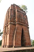
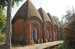
SL. No. Description Location Address District Coordinates Image S-WB-1 Temple of Nandkishore Halisahar North 24 Parganas 22°56′13″N 88°24′52″E / 22.93695°N 88.4145°E / 22.93695; 88.4145 (SL. No. S-WB-1 ) Temple of Nandkishore More images S-WB-2 Surya temple Sonatapal Bankura 23°12′57″N 87°07′35″E / 23.21585°N 87.12644°E / 23.21585; 87.12644 (SL. No. S-WB-2 ) Surya temple More images S-WB-3 Basuli temple (Abandoned) Atbhaichandi Bankura 23°07′46″N 86°58′59″E / 23.12952°N 86.98301°E / 23.12952; 86.98301 (SL. No. S-WB-3 ) Basuli temple (Abandoned) More images S-WB-4 Abandoned temple of Shyamchand Dharapat Bankura 23°07′58″N 87°17′43″E / 23.13266°N 87.29535°E / 23.13266; 87.29535 (SL. No. S-WB-4 ) Abandoned temple of Shyamchand More images S-WB-5 Jain temple Deulbhirra Bankura 22°57′09″N 87°09′41″E / 22.95237°N 87.1615°E / 22.95237; 87.1615 (SL. No. S-WB-5 ) Jain temple More images S-WB-6 Temple of Jhagrai Chandi Uttarbar, Baital Bankura 22°57′49″N 87°29′36″E / 22.96349°N 87.49344°E / 22.96349; 87.49344 (SL. No. S-WB-6 ) Upload Photo S-WB-7 Temple of Lakshmi Janrdan Uttarbadh Baital Bankura Upload Photo S-WB-8 Temple of Shyamchand Dakshinbadh Baital Bankura 22°56′34″N 87°29′18″E / 22.94275°N 87.48827°E / 22.94275; 87.48827 (SL. No. S-WB-8 ) Temple of Shyamchand More images S-WB-9 Abandoned temple of Radhakrishna Bikrampur Bankura 23°09′58″N 87°08′55″E / 23.16608°N 87.14871°E / 23.16608; 87.14871 (SL. No. S-WB-9 ) Abandoned temple of Radhakrishna More images S-WB-10 Temple of Radha Krishna Muninagar Bankura 23°07′25″N 87°22′32″E / 23.12368°N 87.37544°E / 23.12368; 87.37544 (SL. No. S-WB-10 ) Temple of Radha Krishna More images S-WB-11 Abandoned temple of Shyamchand Elyati (Belatukri) Bankura 23°12′25″N 87°10′34″E / 23.20683°N 87.1762°E / 23.20683; 87.1762 (SL. No. S-WB-11 ) Abandoned temple of Shyamchand More images S-WB-12 Abandoned temple Gour Nitai Tejpal Bankura 23°04′45″N 87°18′00″E / 23.0791°N 87.29999°E / 23.0791; 87.29999 (SL. No. S-WB-12 ) Abandoned temple Gour Nitai More images S-WB-13 Abandoned temple of Yadav Rai Jadabnagar Bankura Upload Photo S-WB-14 Temple of Hakanda Moynapur Bankura 23°00′25″N 87°28′57″E / 23.00707°N 87.48243°E / 23.00707; 87.48243 (SL. No. S-WB-14 ) Temple of Hakanda More images S-WB-15 Temple of Damodar Kotulpur (Bazarpara) Bankura 23°01′11″N 87°35′51″E / 23.0196°N 87.5976°E / 23.0196; 87.5976 (SL. No. S-WB-15 ) Temple of Damodar More images S-WB-16 Octagonal Siva temple Supur Birbhum 23°37′44″N 87°41′11″E / 23.62885°N 87.6865°E / 23.62885; 87.6865 (SL. No. S-WB-16 ) Octagonal Siva temple More images S-WB-17 Temple of Kali Itanda Birbhum 23°36′01″N 87°46′02″E / 23.60031°N 87.76714°E / 23.60031; 87.76714 (SL. No. S-WB-17 ) Temple of Kali More images S-WB-18 Navaratna temple Brahmandidhi Birbhum Upload Photo S-WB-19 Temple of Gouranga Ilambazar Birbhum 23°37′37″N 87°32′19″E / 23.62705°N 87.53859°E / 23.62705; 87.53859 (SL. No. S-WB-19 ) Temple of Gouranga More images S-WB-20 Motichur mosque Rajanagar Birbhum 23°56′53″N 87°18′54″E / 23.94792°N 87.31494°E / 23.94792; 87.31494 (SL. No. S-WB-20 ) Motichur mosque More images S-WB-21 Siva temple Ramnagar Birbhum 23°52′40″N 87°51′23″E / 23.87779°N 87.8565°E / 23.87779; 87.8565 (SL. No. S-WB-21 ) Upload Photo S-WB-22 Temple of Dewanji and its contiguous shrines Hetampur Birbhum 23°46′32″N 87°23′54″E / 23.77545°N 87.39839°E / 23.77545; 87.39839 (SL. No. S-WB-22 ) Temple of Dewanji and its contiguous shrines More images S-WB-23 Temple of Chandra Nath Siva Hetampur Birbhum 23°46′35″N 87°23′55″E / 23.77625°N 87.39855°E / 23.77625; 87.39855 (SL. No. S-WB-23 ) Temple of Chandra Nath Siva More images S-WB-24 Siva temple at Panchra Birbhum Upload Photo S-WB-25 Stone Shiva Temple Rasa Birbhum 23°47′21″N 87°12′41″E / 23.78904°N 87.21149°E / 23.78904; 87.21149 (SL. No. S-WB-25 ) Upload Photo S-WB-26 Visnu temple Hatsarandi Birbhum 23°37′52″N 87°49′17″E / 23.63102°N 87.82151°E / 23.63102; 87.82151 (SL. No. S-WB-26 ) Upload Photo S-WB-27 Siva temple adjacent to Kali temple Gonpur Birbhum 24°03′59″N 87°40′21″E / 24.06635°N 87.6724°E / 24.06635; 87.6724 (SL. No. S-WB-27 ) Upload Photo S-WB-28 Siva temple (Raghunatha) Ghurisa Birbhum 23°39′32″N 87°29′39″E / 23.65877°N 87.49421°E / 23.65877; 87.49421 (SL. No. S-WB-28 ) Siva temple (Raghunatha) More images S-WB-29 Malleswar Siva temple Mallarpur Birbhum 24°04′35″N 87°42′06″E / 24.07649°N 87.70158°E / 24.07649; 87.70158 (SL. No. S-WB-29 ) Malleswar Siva temple More images S-WB-30 Kali temple Patharkunchi Birbhum 23°45′25″N 87°18′51″E / 23.75708°N 87.3142°E / 23.75708; 87.3142 (SL. No. S-WB-30 ) Upload Photo S-WB-31 Chand Roy temple Uchkaran Birbhum 23°40′28″N 87°52′33″E / 23.67445°N 87.87594°E / 23.67445; 87.87594 (SL. No. S-WB-31 ) Chand Roy temple S-WB-32 Four Siva temples Uchkaran Birbhum 23°40′27″N 87°52′24″E / 23.67426°N 87.87337°E / 23.67426; 87.87337 (SL. No. S-WB-32 ) Four Siva temples More images S-WB-33 Bhandeswara Siva temple Bhandiswar Birbhum 23°58′27″N 87°28′17″E / 23.97412°N 87.4714°E / 23.97412; 87.4714 (SL. No. S-WB-33 ) Upload Photo S-WB-34 Madan Gopal Temple Amadpur Purba Bardhaman 23°12′24″N 88°05′16″E / 23.20664°N 88.08779°E / 23.20664; 88.08779 (SL. No. S-WB-34 ) Madan Gopal Temple More images S-WB-35 Majlish Saheb or Id-Baqrid mosque Kalna town Purba Bardhaman Majlish Saheb or Id-Baqrid mosque More images S-WB-36 Panchratna brick temple Baidyapur Purba Bardhaman 23°09′39″N 88°14′55″E / 23.16078°N 88.24858°E / 23.16078; 88.24858 (SL. No. S-WB-36 ) Panchratna brick temple More images S-WB-37 Radha Gobinda temple Jagadanandapur Purba Bardhaman 23°34′58″N 88°10′10″E / 23.58278°N 88.16954°E / 23.58278; 88.16954 (SL. No. S-WB-37 ) Radha Gobinda temple More images S-WB-38 Three Siva temple Sribati Purba Bardhaman 23°31′32″N 88°10′15″E / 23.52544°N 88.17083°E / 23.52544; 88.17083 (SL. No. S-WB-38 ) Three Siva temple More images S-WB-39 Badsahi or Hussain Shahi mosque Nutanhat Purba Bardhaman 23°32′17″N 87°54′16″E / 23.53792°N 87.90431°E / 23.53792; 87.90431 (SL. No. S-WB-39 ) Badsahi or Hussain Shahi mosque More images S-WB-40 Siva temple Bonpas Kamarpara Purba Bardhaman 23°23′06″N 87°48′27″E / 23.38495°N 87.80754°E / 23.38495; 87.80754 (SL. No. S-WB-40 ) Siva temple More images S-WB-41 Hussain Shah mosque Kulutia Purba Bardhaman 23°46′29″N 87°57′14″E / 23.77463°N 87.95385°E / 23.77463; 87.95385 (SL. No. S-WB-41 ) Hussain Shah mosque More images S-WB-42 Excavated monument Goswamikhanda Purba Bardhaman Upload Photo S-WB-43 Bijoy - Toran at Burdwan town Burdwan Purba Bardhaman 23°14′25″N 87°52′03″E / 23.24039°N 87.86755°E / 23.24039; 87.86755 (SL. No. S-WB-43 ) Bijoy - Toran at Burdwan town More images S-WB-44 Temple of Kashinath Siva Ajhapur Purba Bardhaman 23°08′24″N 88°03′20″E / 23.14002°N 88.05564°E / 23.14002; 88.05564 (SL. No. S-WB-44 ) Temple of Kashinath Siva More images S-WB-45 Temple of Madan Gopal Kulingram Purba Bardhaman 23°05′25″N 88°07′05″E / 23.0903°N 88.11804°E / 23.0903; 88.11804 (SL. No. S-WB-45 ) Temple of Madan Gopal More images S-WB-46 South Park street Cemetery Park street Kolkata 22°32′48″N 88°21′37″E / 22.54657°N 88.36018°E / 22.54657; 88.36018 (SL. No. S-WB-46 ) South Park street Cemetery More images S-WB-47 The tomb of Admiral Charles Watson, the Mausoleum of Job Charnak and The Tomb of Begun Johnson within the compound of St. John's Church 2/2 Council house street Kolkata 22°34′12″N 88°20′47″E / 22.56997°N 88.34628°E / 22.56997; 88.34628 (SL. No. S-WB-47 ) The tomb of Admiral Charles Watson, the Mausoleum of Job Charnak and The Tomb of Begun Johnson within the compound of St. John's Church S-WB-47-a The tomb of Admiral Charles Watson within the compound of St. John's Church 2/2 Council house street Kolkata 22°34′15″N 88°20′45″E / 22.57079°N 88.34581°E / 22.57079; 88.34581 (SL. No. S-WB-47-a ) The tomb of Admiral Charles Watson within the compound of St. John's Church More images S-WB-47-b The Mausoleum of Job Charnak within the compound of St. John's Church 2/2 Council house street Kolkata 22°34′15″N 88°20′45″E / 22.57097°N 88.34583°E / 22.57097; 88.34583 (SL. No. S-WB-47-b ) The Mausoleum of Job Charnak within the compound of St. John's Church More images S-WB-47-c The Tomb of Begun Johnson within the compound of St. John's Church 2/2 Council house street Kolkata 22°34′16″N 88°20′44″E / 22.5711°N 88.34563°E / 22.5711; 88.34563 (SL. No. S-WB-47-c ) The Tomb of Begun Johnson within the compound of St. John's Church More images S-WB-48 Siddhanath Siva temple Dhaliabari Cooch Behar 26°16′48″N 89°28′07″E / 26.28008°N 89.46863°E / 26.28008; 89.46863 (SL. No. S-WB-48 ) Siddhanath Siva temple More images S-WB-49 The temple of Kamteswari Gosanimari Cooch Behar 26°08′06″N 89°21′44″E / 26.13508°N 89.36225°E / 26.13508; 89.36225 (SL. No. S-WB-49 ) The temple of Kamteswari More images S-WB-50 Baneswar Shiva temple Baneswar Cooch Behar 26°23′55″N 89°29′53″E / 26.39865°N 89.49798°E / 26.39865; 89.49798 (SL. No. S-WB-50 ) Baneswar Shiva temple More images S-WB-51 Henry martin's Pagoda Serampore Hooghly 22°44′49″N 88°21′20″E / 22.74699°N 88.35549°E / 22.74699; 88.35549 (SL. No. S-WB-51 ) Henry martin's Pagoda More images S-WB-52 Raj Rajeswar temple Dwarahatta Hooghly 22°47′36″N 88°04′00″E / 22.79333°N 88.06662°E / 22.79333; 88.06662 (SL. No. S-WB-52 ) Raj Rajeswar temple More images S-WB-53 Chandi temple Deulpara Hooghly 22°53′36″N 87°57′10″E / 22.89335°N 87.95273°E / 22.89335; 87.95273 (SL. No. S-WB-53 ) Upload Photo S-WB-54 Siva temple Bakharpur Hooghly 22°55′59″N 87°58′09″E / 22.93304°N 87.96906°E / 22.93304; 87.96906 (SL. No. S-WB-54 ) Upload Photo S-WB-55 Temple of Gour Chandra and Krishnachandra Chatra Serampore Hooghly 22°45′40″N 88°20′09″E / 22.76106°N 88.3358°E / 22.76106; 88.3358 (SL. No. S-WB-55 ) Temple of Gour Chandra and Krishnachandra More images S-WB-56 Jorbangla temple Parul Arambag Hooghly Upload Photo S-WB-57 Raghunandan temple Parul Arambag Hooghly 22°51′54″N 87°47′59″E / 22.86497°N 87.79966°E / 22.86497; 87.79966 (SL. No. S-WB-57 ) Raghunandan temple More images S-WB-58 Jorbangla temple of Durga with Navaratna tower Bali dewanganj Hooghly 22°48′24″N 87°46′04″E / 22.80666°N 87.76773°E / 22.80666; 87.76773 (SL. No. S-WB-58 ) Jorbangla temple of Durga with Navaratna tower More images S-WB-59 Jami Masjid Bajua Hooghly 22°56′39″N 87°43′26″E / 22.94409°N 87.72392°E / 22.94409; 87.72392 (SL. No. S-WB-59 ) Upload Photo S-WB-60 Radha Govinda temple Antpur Hooghly 22°46′25″N 88°02′48″E / 22.77354°N 88.04653°E / 22.77354; 88.04653 (SL. No. S-WB-60 ) Radha Govinda temple More images S-WB-61 Siva temple Harirampur Hooghly 22°42′27″N 88°04′14″E / 22.70763°N 88.07053°E / 22.70763; 88.07053 (SL. No. S-WB-61 ) Upload Photo S-WB-62 Raj Rajeswar temple Kotalpur Hooghly 22°42′05″N 88°05′14″E / 22.70132°N 88.08724°E / 22.70132; 88.08724 (SL. No. S-WB-62 ) Raj Rajeswar temple More images S-WB-63 Temple of Sri Sri Nandadulal Jiu Gurap Hooghly 23°02′02″N 88°06′38″E / 23.03383°N 88.11059°E / 23.03383; 88.11059 (SL. No. S-WB-63 ) Temple of Sri Sri Nandadulal Jiu More images S-WB-64 The mast of a Portuguese ship Bandal Hooghly 22°55′08″N 88°23′45″E / 22.91892°N 88.39588°E / 22.91892; 88.39588 (SL. No. S-WB-64 ) The mast of a Portuguese ship More images S-WB-65 Kanakeswar Shiva temple Baira Kanpur Hooghly 22°50′24″N 87°49′42″E / 22.83994°N 87.82843°E / 22.83994; 87.82843 (SL. No. S-WB-65 ) Kanakeswar Shiva temple More images S-WB-66 Temple of Dadhimadhab of the Roy family Amraguri Howrah 22°36′30″N 87°55′23″E / 22.60831°N 87.92318°E / 22.60831; 87.92318 (SL. No. S-WB-66 ) Temple of Dadhimadhab of the Roy family More images S-WB-67 Temple of Gopal Jiu Mellock Howrah 22°27′56″N 87°54′12″E / 22.46547°N 87.90323°E / 22.46547; 87.90323 (SL. No. S-WB-67 ) Temple of Gopal Jiu More images S-WB-68 Jatileswar Temple Purbba Dehar Maynaguri Jalpaiguri 26°32′35″N 88°55′07″E / 26.54299°N 88.91854°E / 26.54299; 88.91854 (SL. No. S-WB-68 ) Jatileswar Temple More images S-WB-69 Buxa Fort and prison on mountain cliff Buxa Jalpaiguri 26°45′18″N 89°34′49″E / 26.75506°N 89.58034°E / 26.75506; 89.58034 (SL. No. S-WB-69 ) Buxa Fort and prison on mountain cliff More images S-WB-70 Jami mosque Old Malda municipality Malda 25°02′22″N 88°08′10″E / 25.03932°N 88.13607°E / 25.03932; 88.13607 (SL. No. S-WB-70 ) Jami mosque More images S-WB-71 Ruins of the fortified city of Pandua Pandua Malda Upload Photo S-WB-72 Ruins of Pathan palace at Adian Malda Ruins of Pathan palace at Adian More images S-WB-73 Ancient ruins at Ratnagarh at Wari Malda Upload Photo S-WB-74 Nandadirghi Mahavihara Jagjibanpur Malda 25°02′26″N 88°24′16″E / 25.04058°N 88.40454°E / 25.04058; 88.40454 (SL. No. S-WB-74 ) Nandadirghi Mahavihara More images S-WB-75 Temple of Dakshinakali Malancha Paschim Medinipur 22°20′56″N 87°16′33″E / 22.34877°N 87.2758°E / 22.34877; 87.2758 (SL. No. S-WB-75 ) Temple of Dakshinakali More images S-WB-76 Jagannath temple Dihibahiri Purba Medinipur 21°50′43″N 87°46′51″E / 21.84535°N 87.78089°E / 21.84535; 87.78089 (SL. No. S-WB-76 ) Jagannath temple More images S-WB-77 Jorbangla temple Chandrakona Paschim Medinipur 22°43′39″N 87°30′37″E / 22.72756°N 87.51026°E / 22.72756; 87.51026 (SL. No. S-WB-77 ) Jorbangla temple More images S-WB-78 Shantinatha Shiva Temple Chandrakona Paschim Midnapore 22°44′15″N 87°31′08″E / 22.73761°N 87.5189°E / 22.73761; 87.5189 (SL. No. S-WB-78 ) Shantinatha Shiva Temple More images S-WB-79 Temple of Raghunath Radhanagar Paschim Midnapore 22°41′16″N 87°38′34″E / 22.68783°N 87.64283°E / 22.68783; 87.64283 (SL. No. S-WB-79 ) Temple of Raghunath More images S-WB-80 Temple of Radhagovinda and Radharaman Jiu Gobindanagar Paschim Medinipur 22°31′35″N 87°44′20″E / 22.52646°N 87.73882°E / 22.52646; 87.73882 (SL. No. S-WB-80 ) Temple of Radhagovinda and Radharaman Jiu More images S-WB-81 Maharudra Siddhanath Jiu temple Reyapara Purba Medinipur 22°02′46″N 87°54′22″E / 22.0461°N 87.90615°E / 22.0461; 87.90615 (SL. No. S-WB-81 ) Maharudra Siddhanath Jiu temple S-WB-82 Abandoned temple Ramchandrapur Purba Medinipur Upload Photo S-WB-83 Abandoned temple at Raghunath Radhanagar Paschim Midnapore Upload Photo S-WB-84 Temple of Gopinath Radhakantapur Paschim Medinipur 22°33′57″N 87°43′48″E / 22.56576°N 87.72998°E / 22.56576; 87.72998 (SL. No. S-WB-84 ) Temple of Gopinath More images S-WB-85 Jorsiva temple Rajangar Purba Medinipur 22°26′20″N 87°40′14″E / 22.43897°N 87.67067°E / 22.43897; 87.67067 (SL. No. S-WB-85 ) Upload Photo S-WB-86 Temple of Gopinath Daspur Paschim Medinipur 22°36′17″N 87°43′30″E / 22.60462°N 87.72489°E / 22.60462; 87.72489 (SL. No. S-WB-86 ) Temple of Gopinath More images S-WB-87 Temple of Dandeswar Karnagarh Paschim Medinipur 22°30′26″N 87°21′19″E / 22.50721°N 87.35528°E / 22.50721; 87.35528 (SL. No. S-WB-87 ) Temple of Dandeswar More images S-WB-88 Temple of Mahamaya Karnagarh Paschim Medinipur 22°30′26″N 87°21′19″E / 22.5071°N 87.3554°E / 22.5071; 87.3554 (SL. No. S-WB-88 ) Temple of Mahamaya More images S-WB-89 Tomb of Nawab Sharfaraz Khan at Naginabagh Murshidabad Murshidabad Tomb of Nawab Sharfaraz Khan at Naginabagh S-WB-90 Temple of Gangeswar Siva Baranagar Murshidabad 24°15′16″N 88°14′32″E / 24.25454°N 88.2422°E / 24.25454; 88.2422 (SL. No. S-WB-90 ) Temple of Gangeswar Siva More images S-WB-91 Siva temple Yugwara Murshidabad 23°55′20″N 87°54′22″E / 23.9222°N 87.906°E / 23.9222; 87.906 (SL. No. S-WB-91 ) Upload Photo S-WB-92 Navratna temple Sibarambati Murshidabad 23°53′16″N 87°59′19″E / 23.88772°N 87.98865°E / 23.88772; 87.98865 (SL. No. S-WB-92 ) Upload Photo S-WB-93 Ratneshwar Siva temple Bilbari Murshidabad 24°10′00″N 88°13′08″E / 24.16664°N 88.21875°E / 24.16664; 88.21875 (SL. No. S-WB-93 ) Upload Photo S-WB-94 The house, temples and ruins associated with memory of Jagat Sett 's house Mahimapur Murshidabad 24°12′33″N 88°15′44″E / 24.20917°N 88.26228°E / 24.20917; 88.26228 (SL. No. S-WB-94 ) The house, temples and ruins associated with memory of Jagat Sett 's house More images S-WB-95 Temple of Raghabeswar Siva Dignagar Nadia 23°19′20″N 88°27′10″E / 23.32217°N 88.45285°E / 23.32217; 88.45285 (SL. No. S-WB-95 ) Temple of Raghabeswar Siva More images S-WB-96 Temple of Shyamchand Santipur town Nadia 23°14′23″N 88°26′29″E / 23.23972°N 88.44152°E / 23.23972; 88.44152 (SL. No. S-WB-96 ) Temple of Shyamchand More images S-WB-97 Durga temple Para Purulia 23°30′41″N 86°30′36″E / 23.51136°N 86.50997°E / 23.51136; 86.50997 (SL. No. S-WB-97 ) Durga temple More images S-WB-98 Mound Haraktore Purulia 23°31′31″N 86°27′14″E / 23.5252°N 86.45385°E / 23.5252; 86.45385 (SL. No. S-WB-98 ) Mound More images S-WB-99 Radha Gibinda temple Cheliyama Purulia 23°37′01″N 86°33′11″E / 23.61684°N 86.55314°E / 23.61684; 86.55314 (SL. No. S-WB-99 ) Radha Gibinda temple More images S-WB-100 Siva temple Krosjuri Purulia 23°22′20″N 86°44′57″E / 23.37235°N 86.7492°E / 23.37235; 86.7492 (SL. No. S-WB-100 ) Siva temple More images S-WB-101 Jain temple Pakbirra Purulia 23°09′32″N 86°40′48″E / 23.15897°N 86.67998°E / 23.15897; 86.67998 (SL. No. S-WB-101 ) Jain temple More images S-WB-102 Basudeb temple in ruins Arsha Purulia Upload Photo S-WB-103 Jain and other images in stone Suisa Purulia 23°11′34″N 85°54′15″E / 23.19276°N 85.90405°E / 23.19276; 85.90405 (SL. No. S-WB-103 ) Jain and other images in stone More images S-WB-104 Rashmandir Begunkodar Purulia 23°21′10″N 86°03′31″E / 23.35265°N 86.05873°E / 23.35265; 86.05873 (SL. No. S-WB-104 ) Rashmandir More images S-WB-105 Temple of Bhairab Bindole Uttar Dinajpur 25°46′01″N 88°10′47″E / 25.76704°N 88.1797°E / 25.76704; 88.1797 (SL. No. S-WB-105 ) Temple of Bhairab More images S-WB-106 Ruins of Fort Ekdala Bahirhatta Uttar Dinajpur Upload Photo