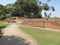
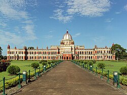
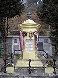
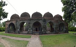
SL. No. Description Location Address District Coordinates Image N-WB-1 Chandraketu's Fort Berachampa 24 Parganas (North) 22°40′47″N 88°41′29″E / 22.67972°N 88.69133°E / 22.67972; 88.69133 (SL. No. N-WB-1 ) Chandraketu's Fort More images N-WB-2 Ancient mound known as Barah Mihirer Dhipi also known as Khana Mihirer Dhibi Deulia & Kaukipara 24 Parganas (North) 22°41′51″N 88°41′19″E / 22.69739°N 88.68854°E / 22.69739; 88.68854 (SL. No. N-WB-2 ) Ancient mound known as Barah Mihirer Dhipi also known as Khana Mihirer Dhibi More images N-WB-3 Clive's House Dum Dum known as Barakothi Dum Dum 24 Parganas (North) 22°37′33″N 88°24′57″E / 22.62586°N 88.41584°E / 22.62586; 88.41584 (SL. No. N-WB-3 ) Clive's House Dum Dum known as Barakothi More images N-WB-4 26 Siva Temples Barrackpore - Khardaha 24 Parganas (North) 22°43′31″N 88°21′45″E / 22.72518°N 88.36252°E / 22.72518; 88.36252 (SL. No. N-WB-4 ) 26 Siva Temples More images N-WB-5 Warren Hasting's House Barasat 24 Parganas (North) 22°43′21″N 88°29′17″E / 22.72245°N 88.48793°E / 22.72245; 88.48793 (SL. No. N-WB-5 ) Warren Hasting's House More images N-WB-6 Jatar Deul Jata 24 Parganas (South) 21°59′40″N 88°29′24″E / 21.99451°N 88.48993°E / 21.99451; 88.48993 (SL. No. N-WB-6 ) Jatar Deul More images N-WB-7 Bahulara Ancient Temple Bahulara Bankura 23°09′58″N 87°14′07″E / 23.16617°N 87.23518°E / 23.16617; 87.23518 (SL. No. N-WB-7 ) Bahulara Ancient Temple More images N-WB-8 Dalmadal Cannon and the platform on which it is mounted Bishnupur Bankura 23°03′48″N 87°19′15″E / 23.06322°N 87.32096°E / 23.06322; 87.32096 (SL. No. N-WB-8 ) Dalmadal Cannon and the platform on which it is mounted More images N-WB-9 Gate of Old Fort Bishnupur Bankura 23°04′28″N 87°19′34″E / 23.07432°N 87.32624°E / 23.07432; 87.32624 (SL. No. N-WB-9 ) Gate of Old Fort More images N-WB-10 Jor Mandir Bishnupur Bankura 23°03′37″N 87°19′19″E / 23.06014°N 87.32182°E / 23.06014; 87.32182 (SL. No. N-WB-10 ) Jor Mandir More images N-WB-11 Jor Bangla Temple Bishnupur Bankura 23°04′18″N 87°19′36″E / 23.07171°N 87.32679°E / 23.07171; 87.32679 (SL. No. N-WB-11 ) Jor Bangla Temple More images N-WB-12 Kalachand Temple Bishnupur Bankura 23°03′32″N 87°19′33″E / 23.05902°N 87.32591°E / 23.05902; 87.32591 (SL. No. N-WB-12 ) Kalachand Temple More images N-WB-13 Lalji Temple Bishnupur Bankura 23°04′24″N 87°19′37″E / 23.07342°N 87.32692°E / 23.07342; 87.32692 (SL. No. N-WB-13 ) Lalji Temple More images N-WB-14 Madan Gopal Temple Bishnupur Bankura 23°04′35″N 87°18′43″E / 23.07651°N 87.31184°E / 23.07651; 87.31184 (SL. No. N-WB-14 ) Madan Gopal Temple More images N-WB-15 Madan Mohan Temple Bishnupur Bankura 23°04′51″N 87°19′24″E / 23.08073°N 87.32346°E / 23.08073; 87.32346 (SL. No. N-WB-15 ) Madan Mohan Temple More images N-WB-16 Malleswar Temple Bishnupur Bankura 23°04′47″N 87°19′13″E / 23.07985°N 87.32023°E / 23.07985; 87.32023 (SL. No. N-WB-16 ) Malleswar Temple More images N-WB-17 Murali Mohan Temple Bishnupur Bankura 23°04′55″N 87°19′04″E / 23.08204°N 87.31773°E / 23.08204; 87.31773 (SL. No. N-WB-17 ) Murali Mohan Temple More images N-WB-18 Nanda Lal Temple Bishnupur Bankura 23°03′41″N 87°19′23″E / 23.06146°N 87.32302°E / 23.06146; 87.32302 (SL. No. N-WB-18 ) Nanda Lal Temple More images N-WB-19 Patpur Temple Bishnupur Bankura 23°04′30″N 87°20′14″E / 23.07513°N 87.33719°E / 23.07513; 87.33719 (SL. No. N-WB-19 ) Patpur Temple More images N-WB-20 Radha Binod Temple Bishnupur Bankura 23°04′51″N 87°19′40″E / 23.08079°N 87.32771°E / 23.08079; 87.32771 (SL. No. N-WB-20 ) Radha Binod Temple More images N-WB-21 Radha Gobind Temple Bishnupur Bankura 23°03′36″N 87°19′23″E / 23.0601°N 87.32314°E / 23.0601; 87.32314 (SL. No. N-WB-21 ) Radha Gobind Temple More images N-WB-22 Radha Madhab Temple Bishnupur Bankura 23°03′35″N 87°19′29″E / 23.05962°N 87.32465°E / 23.05962; 87.32465 (SL. No. N-WB-22 ) Radha Madhab Temple More images N-WB-23 Radha Shyam Temple Bishnupur Bankura 23°04′21″N 87°19′35″E / 23.0725°N 87.32643°E / 23.0725; 87.32643 (SL. No. N-WB-23 ) Radha Shyam Temple More images N-WB-24 Rasmancha Bishnupur Bankura 23°04′06″N 87°19′19″E / 23.06841°N 87.32203°E / 23.06841; 87.32203 (SL. No. N-WB-24 ) Rasmancha More images N-WB-25 Shyam Rai Temple Bishnupur Bankura 23°04′16″N 87°19′27″E / 23.07108°N 87.32407°E / 23.07108; 87.32407 (SL. No. N-WB-25 ) Shyam Rai Temple More images N-WB-26 Small gateway of fort Bishnupur Bankura 23°04′29″N 87°19′33″E / 23.07474°N 87.32578°E / 23.07474; 87.32578 (SL. No. N-WB-26 ) Small gateway of fort More images N-WB-27 Stone chariot Bishnupur Bankura 23°04′32″N 87°19′34″E / 23.07543°N 87.32604°E / 23.07543; 87.32604 (SL. No. N-WB-27 ) Stone chariot More images N-WB-28 Saileswar Temple Dihar Bankura 23°07′08″N 87°20′51″E / 23.11886°N 87.34744°E / 23.11886; 87.34744 (SL. No. N-WB-28 ) Saileswar Temple More images N-WB-29 Sareswar Temple Dihar Bankura 23°07′09″N 87°20′51″E / 23.1191°N 87.34744°E / 23.1191; 87.34744 (SL. No. N-WB-29 ) Sareswar Temple More images N-WB-30 Temple of Radha Damodar Jew Ghutgarya Bankura 23°26′12″N 87°15′18″E / 23.4366°N 87.25512°E / 23.4366; 87.25512 (SL. No. N-WB-30 ) Temple of Radha Damodar Jew More images N-WB-31 Gokulchand Temple Gokulnagar Bankura 23°02′13″N 87°27′43″E / 23.03681°N 87.46184°E / 23.03681; 87.46184 (SL. No. N-WB-31 ) Gokulchand Temple More images N-WB-32 Temple of Ratneswar Jagannathpur Bankura 23°20′55″N 87°17′59″E / 23.34863°N 87.29985°E / 23.34863; 87.29985 (SL. No. N-WB-32 ) Upload Photo N-WB-33 Temple of Shyam Sunder Madanpur Bankura 23°24′16″N 87°23′48″E / 23.40431°N 87.3967°E / 23.40431; 87.3967 (SL. No. N-WB-33 ) Upload Photo N-WB-34 Temple site now represented only by a mound and a statue of Surya Pareshnath Bankura Upload Photo N-WB-35 Temple site of an old Jain Temple now represented only by a Mound with a Jain statue Pareshnath Bankura 22°57′28″N 86°44′57″E / 22.95783°N 86.74903°E / 22.95783; 86.74903 (SL. No. N-WB-35 ) Temple site of an old Jain Temple now represented only by a Mound with a Jain statue More images N-WB-36 Image of Durga slaying Mahisasura under a tree Sarengarh Bankura Upload Photo N-WB-37 Temple site now represented only by a mound Sarengarh Bankura Upload Photo N-WB-38 Temple site now represented only by a Mound with statues of Ganesh and Nandi on it Sarengarh Bankura Upload Photo N-WB-39 Temple site now represented only by a mound with an Image of Nandi on it Sarengarh Bankura Upload Photo N-WB-40 Rock Inscription of Chandra Varman Susunia Hill Bankura 23°23′32″N 86°59′05″E / 23.39221°N 86.98482°E / 23.39221; 86.98482 (SL. No. N-WB-40 ) Rock Inscription of Chandra Varman More images N-WB-41 Temple of Radha Binod commonly known as Joydeb Jaydev Kenduli Birbhum 23°38′32″N 87°25′50″E / 23.64216°N 87.43051°E / 23.64216; 87.43051 (SL. No. N-WB-41 ) Temple of Radha Binod commonly known as Joydeb More images N-WB-42 Temple of Dharmaraj Kubilashpur Birbhum 23°57′35″N 87°22′10″E / 23.95964°N 87.36939°E / 23.95964; 87.36939 (SL. No. N-WB-42 ) Upload Photo N-WB-43 Two mounds Bhadeswar Birbhum Upload Photo N-WB-44 Temple of Basuli and the mound together with fourteen other temples near them containing the Linga images of Shiva Nanoor Birbhum 23°42′17″N 87°52′06″E / 23.70459°N 87.8684°E / 23.70459; 87.8684 (SL. No. N-WB-44 ) Temple of Basuli and the mound together with fourteen other temples near them containing the Linga images of Shiva More images N-WB-45 Temple and Rasmancha (Damodar Temple) Suri Birbhum 23°54′15″N 87°31′56″E / 23.90408°N 87.53214°E / 23.90408; 87.53214 (SL. No. N-WB-45 ) Temple and Rasmancha (Damodar Temple) More images N-WB-46 Baidyapur Jora Deul Baidyapur Purba Bardhaman 23°09′35″N 88°14′48″E / 23.159761°N 88.246568°E / 23.159761; 88.246568 (SL. No. N-WB-46 ) Baidyapur Jora Deul More images N-WB-47 Rarheswar Temple Bamunara Paschim Bardhaman 23°30′57″N 87°22′44″E / 23.51575°N 87.37884°E / 23.51575; 87.37884 (SL. No. N-WB-47 ) Rarheswar Temple More images N-WB-48 Begunia temples Barakar Paschim Bardhaman 23°44′08″N 86°48′49″E / 23.73554°N 86.81353°E / 23.73554; 86.81353 (SL. No. N-WB-48 ) Begunia temples More images N-WB-49 Tomb of Baharam Sakka, Sher Afghan and Nawab Qutabuddin Bardhaman Purba Bardhaman 23°14′05″N 87°51′08″E / 23.23473°N 87.85234°E / 23.23473; 87.85234 (SL. No. N-WB-49 ) Tomb of Baharam Sakka, Sher Afghan and Nawab Qutabuddin More images N-WB-50 Stone Temple Garui Paschim Bardhaman 23°43′08″N 86°56′29″E / 23.71883°N 86.94151°E / 23.71883; 86.94151 (SL. No. N-WB-50 ) Stone Temple More images N-WB-51 Temple of Ichai Ghosh Gourangapur Paschim Bardhaman 23°36′34″N 87°27′07″E / 23.60941°N 87.45197°E / 23.60941; 87.45197 (SL. No. N-WB-51 ) Temple of Ichai Ghosh More images N-WB-52 Ancient site Nadhia Burdwan Upload Photo N-WB-53 Jain brick temple known as Sat Deul Deulia Purba Bardhaman 23°09′05″N 88°02′40″E / 23.151257°N 88.044409°E / 23.151257; 88.044409 (SL. No. N-WB-53 ) Jain brick temple known as Sat Deul More images N-WB-54 Group of 12 temples as below Kalna Purba Bardhaman Group of 12 temples as below N-WB-54-a (i) Bijoy Vaidyanath Temple Kalna Purba Bardhaman 23°13′17″N 88°21′57″E / 23.22128°N 88.36572°E / 23.22128; 88.36572 (SL. No. N-WB-54-a ) (i) Bijoy Vaidyanath Temple More images N-WB-54-b (ii) Giri Gobardhan Temple Kalna Purba Bardhaman 23°13′18″N 88°21′54″E / 23.22165°N 88.36501°E / 23.22165; 88.36501 (SL. No. N-WB-54-b ) (ii) Giri Gobardhan Temple More images N-WB-54-c (iii) Gopalji Temple Kalna Purba Bardhaman 23°13′32″N 88°21′33″E / 23.22563°N 88.3591°E / 23.22563; 88.3591 (SL. No. N-WB-54-c ) (iii) Gopalji Temple More images N-WB-54-d (iv) Jaleswar Temple Kalna Purba Bardhaman 23°13′15″N 88°21′52″E / 23.22075°N 88.36439°E / 23.22075; 88.36439 (SL. No. N-WB-54-d ) (iv) Jaleswar Temple More images N-WB-54-e (v) Krishna Chandraji Temple Kalna Purba Bardhaman 23°13′16″N 88°21′56″E / 23.22111°N 88.36564°E / 23.22111; 88.36564 (SL. No. N-WB-54-e ) (v) Krishna Chandraji Temple More images N-WB-54-f (vi) Lalji Temple Kalna Purba Bardhaman 23°13′19″N 88°21′55″E / 23.22194°N 88.36523°E / 23.22194; 88.36523 (SL. No. N-WB-54-f ) (vi) Lalji Temple More images N-WB-54-g (vii) Nava-Kailasha Temple Kalna Purba Bardhaman 23°13′13″N 88°21′53″E / 23.2204°N 88.36476°E / 23.2204; 88.36476 (SL. No. N-WB-54-g ) (vii) Nava-Kailasha Temple More images N-WB-54-h (viii) Pancharatha Temple Kalna Purba Bardhaman 23°13′17″N 88°21′55″E / 23.22125°N 88.36536°E / 23.22125; 88.36536 (SL. No. N-WB-54-h ) (viii) Pancharatha Temple More images N-WB-54-i (ix) Pratapeswar Siva Temple in Rajbari compound Kalna Purba Bardhaman 23°13′16″N 88°21′54″E / 23.22103°N 88.36487°E / 23.22103; 88.36487 (SL. No. N-WB-54-i ) (ix) Pratapeswar Siva Temple in Rajbari compound More images N-WB-54-j (x) Rameswar Temple Kalna Purba Bardhaman 23°13′21″N 88°21′53″E / 23.22246°N 88.36478°E / 23.22246; 88.36478 (SL. No. N-WB-54-j ) (x) Rameswar Temple More images N-WB-54-k (xi) Ratneswar Temple Kalna Purba Bardhaman 23°13′14″N 88°21′55″E / 23.22046°N 88.36534°E / 23.22046; 88.36534 (SL. No. N-WB-54-k ) (xi) Ratneswar Temple More images N-WB-54-l (xii) Rupeswar Temple Kalna Purba Bardhaman 23°13′17″N 88°21′55″E / 23.22142°N 88.36531°E / 23.22142; 88.36531 (SL. No. N-WB-54-l ) (xii) Rupeswar Temple More images N-WB-55 Ancient site and remains of Pandu Rajar Dhibi Panduk Purba Bardhaman 23°34′53″N 87°38′33″E / 23.58146°N 87.64238°E / 23.58146; 87.64238 (SL. No. N-WB-55 ) Ancient site and remains of Pandu Rajar Dhibi More images N-WB-56 Ancient mound Bharatpur Purba Bardhaman 23°24′42″N 87°26′48″E / 23.41168°N 87.44667°E / 23.41168; 87.44667 (SL. No. N-WB-56 ) Ancient mound More images N-WB-57 Cooch Behar Palace Cooch Bihar Cooch Bihar 26°19′37″N 89°26′19″E / 26.32703°N 89.43872°E / 26.32703; 89.43872 (SL. No. N-WB-57 ) Cooch Behar Palace More images N-WB-58 Rajpat Khalisa Gosanimari Cooch Bihar 26°09′05″N 89°21′01″E / 26.15128°N 89.35019°E / 26.15128; 89.35019 (SL. No. N-WB-58 ) Rajpat More images N-WB-59 Tomb of Alexander-Cosma de Koros Darjeeling Darjeeling 27°03′09″N 88°15′33″E / 27.05238°N 88.25916°E / 27.05238; 88.25916 (SL. No. N-WB-59 ) Tomb of Alexander-Cosma de Koros More images N-WB-60 Tomb of General George W. Aylmer Lloyd Darjeeling Darjeeling 27°03′09″N 88°15′32″E / 27.05262°N 88.25888°E / 27.05262; 88.25888 (SL. No. N-WB-60 ) Tomb of General George W. Aylmer Lloyd More images N-WB-61 Dargah of Shah Ata Gangarampur Dinajpur (South) 25°24′03″N 88°31′53″E / 25.40091°N 88.53141°E / 25.40091; 88.53141 (SL. No. N-WB-61 ) Dargah of Shah Ata More images N-WB-62 Bangarh Gangarampur Dinajpur (South) 25°24′51″N 88°31′41″E / 25.41424°N 88.52811°E / 25.41424; 88.52811 (SL. No. N-WB-62 ) Bangarh More images N-WB-63 a Hangeshwari Temple Bansberia Hooghly 22°57′51″N 88°23′59″E / 22.96428°N 88.39979°E / 22.96428; 88.39979 (SL. No. N-WB-63 a ) Hangeshwari Temple More images N-WB-63 b Ananta Basudeba Temple Bansberia Hooghly 22°57′52″N 88°23′58″E / 22.96435°N 88.39951°E / 22.96435; 88.39951 (SL. No. N-WB-63 b ) Ananta Basudeba Temple More images N-WB-64 Dutch Cemetery, Chinsurah Chinsurah Hooghly 22°53′25″N 88°23′30″E / 22.89017°N 88.39179°E / 22.89017; 88.39179 (SL. No. N-WB-64 ) Dutch Cemetery, Chinsurah More images N-WB-65 Dutch Memorial monument of Susan Anna Maria Chinsurah Hooghly 22°53′01″N 88°22′48″E / 22.8835°N 88.38005°E / 22.8835; 88.38005 (SL. No. N-WB-65 ) Dutch Memorial monument of Susan Anna Maria More images N-WB-66 Group of temples known as Brindaban Chandra's Math Guptipara Hooghly 23°11′49″N 88°26′27″E / 23.19692°N 88.4408°E / 23.19692; 88.4408 (SL. No. N-WB-66 ) Group of temples known as Brindaban Chandra's Math More images N-WB-67 Mounds Mahanad Hooghly Upload Photo N-WB-68 Minar Pandua Hooghly 23°04′28″N 88°17′04″E / 23.074337°N 88.2844928°E / 23.074337; 88.2844928 (SL. No. N-WB-68 ) Minar More images N-WB-69 Mosque Pandua Hooghly 23°04′26″N 88°17′03″E / 23.0739488°N 88.2841073°E / 23.0739488; 88.2841073 (SL. No. N-WB-69 ) Mosque More images N-WB-70 Sayed Jamaluddin Mosque & Tombs Saptagram Hooghly 22°57′38″N 88°22′10″E / 22.96045°N 88.36958°E / 22.96045; 88.36958 (SL. No. N-WB-70 ) Sayed Jamaluddin Mosque & Tombs More images N-WB-71 Danish Cemetery Serampore Hooghly 22°45′10″N 88°20′41″E / 22.75287°N 88.34475°E / 22.75287; 88.34475 (SL. No. N-WB-71 ) Danish Cemetery More images N-WB-72 Shrine and Mosque known as Dargah of Zafar Khan Gazi Tribeni Hooghly 22°58′46″N 88°24′04″E / 22.97957°N 88.40098°E / 22.97957; 88.40098 (SL. No. N-WB-72 ) Shrine and Mosque known as Dargah of Zafar Khan Gazi More images N-WB-73 Dupleix Palace Chandan Nagar Hooghly 22°51′24″N 88°22′10″E / 22.8566°N 88.36937°E / 22.8566; 88.36937 (SL. No. N-WB-73 ) Dupleix Palace More images N-WB-74 Sri Mayer Ghat Howrah Howrah 22°37′55″N 88°21′27″E / 22.63193°N 88.35747°E / 22.63193; 88.35747 (SL. No. N-WB-74 ) Sri Mayer Ghat More images N-WB-75 Metcalfe Hall Kolkata Kolkata 22°34′18″N 88°20′41″E / 22.57152778°N 88.34472222°E / 22.57152778; 88.34472222 (SL. No. N-WB-75 ) Metcalfe Hall More images N-WB-76 St. John’s Church (Fabrics of the Church) (final notification not issued) Kolkata Kolkata 22°34′12″N 88°20′47″E / 22.569911°N 88.346297°E / 22.569911; 88.346297 (SL. No. N-WB-76 ) St. John’s Church (Fabrics of the Church) (final notification not issued) More images N-WB-77 Currency Building Dalhousie Square Kolkata 22°34′14″N 88°21′01″E / 22.57056°N 88.35028°E / 22.57056; 88.35028 (SL. No. N-WB-77 ) Currency Building More images N-WB-78 Asiatic Society Building Park Street 1 Park Street. Kolkata - 700 016. Kolkata 22°33′17″N 88°21′04″E / 22.55486°N 88.35105°E / 22.55486; 88.35105 (SL. No. N-WB-78 ) Asiatic Society Building More images N-WB-79 Maghen David Synagogue Ward No. 45 Kolkata 22°34′40″N 88°21′07″E / 22.57768°N 88.35185°E / 22.57768; 88.35185 (SL. No. N-WB-79 ) Maghen David Synagogue More images N-WB-80 Beth-el-Synagogue Pollock Street Kolkata 22°34′33″N 88°21′08″E / 22.57576°N 88.35228°E / 22.57576; 88.35228 (SL. No. N-WB-80 ) Beth-el-Synagogue More images N-WB-81 Adina Mosque Pandua Malda 25°09′10″N 88°09′50″E / 25.15274°N 88.16384°E / 25.15274; 88.16384 (SL. No. N-WB-81 ) Adina Mosque More images N-WB-82 Baisgazi Wall Gaur Malda 24°52′15″N 88°07′31″E / 24.87087°N 88.12537°E / 24.87087; 88.12537 (SL. No. N-WB-82 ) Baisgazi Wall More images N-WB-83 Baraduary Masjid or the Great Golden Mosque Gaur Malda 24°52′59″N 88°07′41″E / 24.88292°N 88.12799°E / 24.88292; 88.12799 (SL. No. N-WB-83 ) Baraduary Masjid or the Great Golden Mosque More images N-WB-84 Bhita of Chand Sadagar Gaur Malda 24°51′59″N 88°08′32″E / 24.8664°N 88.14228°E / 24.8664; 88.14228 (SL. No. N-WB-84 ) Bhita of Chand Sadagar More images N-WB-85 Chamkati Masjid Gaur Malda 24°52′13″N 88°08′09″E / 24.87032°N 88.13573°E / 24.87032; 88.13573 (SL. No. N-WB-85 ) Chamkati Masjid More images N-WB-86 Chika Masjid Gaur Malda 24°52′04″N 88°07′53″E / 24.86765°N 88.13136°E / 24.86765; 88.13136 (SL. No. N-WB-86 ) Chika Masjid More images N-WB-87 Dakhil Darwaza Gaur Malda 24°52′44″N 88°07′30″E / 24.87899°N 88.12507°E / 24.87899; 88.12507 (SL. No. N-WB-87 ) Dakhil Darwaza More images N-WB-88 Firoz Minar Gaur Malda 24°52′25″N 88°07′49″E / 24.8737202°N 88.1303984°E / 24.8737202; 88.1303984 (SL. No. N-WB-88 ) Firoz Minar More images N-WB-89 Gumti Gateway Gaur Malda 24°52′04″N 88°07′56″E / 24.86787°N 88.13211°E / 24.86787; 88.13211 (SL. No. N-WB-89 ) Gumti Gateway More images N-WB-90 Gunmant Mosque Gaur Malda 24°51′05″N 88°07′53″E / 24.85144°N 88.13144°E / 24.85144; 88.13144 (SL. No. N-WB-90 ) Gunmant Mosque More images N-WB-91 Kotwali Darwaja Gaur Malda 24°50′34″N 88°08′28″E / 24.84286°N 88.14104°E / 24.84286; 88.14104 (SL. No. N-WB-91 ) Kotwali Darwaja More images N-WB-92 Lottan Masjid Gaur Malda 24°51′18″N 88°08′22″E / 24.85499°N 88.13955°E / 24.85499; 88.13955 (SL. No. N-WB-92 ) Lottan Masjid More images N-WB-93 Lukachuri Gateway Gaur Malda 24°52′07″N 88°07′55″E / 24.86851°N 88.13201°E / 24.86851; 88.13201 (SL. No. N-WB-93 ) Lukachuri Gateway More images N-WB-94 Qadam Rasul Mosque Gaur Malda 24°52′09″N 88°07′54″E / 24.86926°N 88.13164°E / 24.86926; 88.13164 (SL. No. N-WB-94 ) Qadam Rasul Mosque More images N-WB-95 Tomb of Fateh Khan Gaur Malda 24°52′09″N 88°07′54″E / 24.8691°N 88.13175°E / 24.8691; 88.13175 (SL. No. N-WB-95 ) Tomb of Fateh Khan More images N-WB-96 Tantipara Masjid Gaur Malda 24°51′39″N 88°08′13″E / 24.86078°N 88.13707°E / 24.86078; 88.13707 (SL. No. N-WB-96 ) Tantipara Masjid More images N-WB-97 Two tombs in front of Tantipura Masjid Gaur Malda 24°51′38″N 88°08′15″E / 24.86068°N 88.13747°E / 24.86068; 88.13747 (SL. No. N-WB-97 ) Two tombs in front of Tantipura Masjid More images N-WB-98 Two stone pillars Gaur Malda 24°54′35″N 88°08′00″E / 24.90981°N 88.13332°E / 24.90981; 88.13332 (SL. No. N-WB-98 ) Two stone pillars More images N-WB-99 Tower Nimasarai Malda 25°02′22″N 88°07′52″E / 25.03951°N 88.13106°E / 25.03951; 88.13106 (SL. No. N-WB-99 ) Tower More images N-WB-100 Eklakhi Mausoleum Pandua Malda 25°08′20″N 88°09′15″E / 25.1388°N 88.15425°E / 25.1388; 88.15425 (SL. No. N-WB-100 ) Eklakhi Mausoleum More images N-WB-101 Qutub Shahi Masjid Pandua Malda 25°08′19″N 88°09′12″E / 25.13863°N 88.15342°E / 25.13863; 88.15342 (SL. No. N-WB-101 ) Qutub Shahi Masjid More images N-WB-102 Dharmaraj Temple Pathra Paschim Medinipur 22°24′30″N 87°24′58″E / 22.40847°N 87.4161°E / 22.40847; 87.4161 (SL. No. N-WB-102 ) Dharmaraj Temple More images N-WB-103 Temples of Bandyopadhyay Family Pathra Paschim Medinipur 22°24′43″N 87°25′10″E / 22.41203°N 87.41946°E / 22.41203; 87.41946 (SL. No. N-WB-103 ) Temples of Bandyopadhyay Family More images N-WB-104 Sitala Temples Pathra Paschim Medinipur 22°24′30″N 87°25′13″E / 22.40839°N 87.42024°E / 22.40839; 87.42024 (SL. No. N-WB-104 ) Sitala Temples More images N-WB-105 Navratna Temple Complex Pathra Paschim Medinipur 22°24′31″N 87°25′03″E / 22.40872°N 87.41759°E / 22.40872; 87.41759 (SL. No. N-WB-105 ) Navratna Temple Complex More images N-WB-106 Kurumbera Fort Gaganeswar Paschim Medinipur 22°05′16″N 87°15′18″E / 22.08782°N 87.25511°E / 22.08782; 87.25511 (SL. No. N-WB-106 ) Kurumbera Fort More images N-WB-107 John Pierce Tomb Midnapore Paschim Medinipur 22°24′38″N 87°18′49″E / 22.41042°N 87.3137°E / 22.41042; 87.3137 (SL. No. N-WB-107 ) John Pierce Tomb More images N-WB-108 Tomb of Azimunnisha Begum daughter of Murshid Quli Khan Azimnagar Murshidabad 24°11′54″N 88°15′54″E / 24.19822°N 88.26491°E / 24.19822; 88.26491 (SL. No. N-WB-108 ) Tomb of Azimunnisha Begum daughter of Murshid Quli Khan More images N-WB-109 Residency Cemetery also known as ‘Station Burial ground’ Babulbona Beharampore Murshidabad 24°05′47″N 88°15′50″E / 24.09635°N 88.26391°E / 24.09635; 88.26391 (SL. No. N-WB-109 ) Residency Cemetery also known as ‘Station Burial ground’ More images N-WB-110 Bhavaniswar Mandir Baranagar Murshidabad 24°15′07″N 88°14′36″E / 24.25208°N 88.2432°E / 24.25208; 88.2432 (SL. No. N-WB-110 ) Bhavaniswar Mandir More images N-WB-111 Char Bangla group of four Siva Mandirs Baranagar Murshidabad 24°15′05″N 88°14′38″E / 24.25141°N 88.24385°E / 24.25141; 88.24385 (SL. No. N-WB-111 ) Char Bangla group of four Siva Mandirs More images N-WB-112 Tomb of Mir Madan Faridpur Murshidabad 23°50′49″N 88°13′54″E / 23.84691°N 88.23161°E / 23.84691; 88.23161 (SL. No. N-WB-112 ) Tomb of Mir Madan More images N-WB-113 Dutch Cemetery Kalikapur Murshidabad 24°07′25″N 88°15′59″E / 24.12358°N 88.26636°E / 24.12358; 88.26636 (SL. No. N-WB-113 ) Dutch Cemetery More images N-WB-114 Old English Cemetery or Old Residency Burial Ground Cossimbazar Murshidabad 24°07′25″N 88°16′34″E / 24.12368°N 88.27604°E / 24.12368; 88.27604 (SL. No. N-WB-114 ) Upload Photo N-WB-115 Kherur Mosque Kheraul Murshidabad 24°20′59″N 88°04′25″E / 24.3496°N 88.07349°E / 24.3496; 88.07349 (SL. No. N-WB-115 ) Kherur Mosque More images N-WB-116 Tomb of Alivardi Khan & the tomb of Seraj-ud-daullah Khosbag Murshidabad 24°09′39″N 88°15′30″E / 24.16079°N 88.25828°E / 24.16079; 88.25828 (SL. No. N-WB-116 ) Tomb of Alivardi Khan & the tomb of Seraj-ud-daullah More images N-WB-117 Mound known as Barkona Deul Mound Panchthupi Murshidabad Upload Photo N-WB-118 Mounds known as the Devil's Mound and Raja Karna's Palace Rangamati Murshidabad 24°01′49″N 88°11′27″E / 24.03018°N 88.19091°E / 24.03018; 88.19091 (SL. No. N-WB-118 ) Mounds known as the Devil's Mound and Raja Karna's Palace More images N-WB-119 Tomb of Sujauddin Roshnibagh Murshidabad 24°11′09″N 88°15′51″E / 24.1857°N 88.26426°E / 24.1857; 88.26426 (SL. No. N-WB-119 ) Tomb of Sujauddin N-WB-120 Tomb and Mosque of Murhsid Kuli Khan (also: Katra Masjid ) Sabz Katra Murshidabad 24°11′05″N 88°17′17″E / 24.184722°N 88.288056°E / 24.184722; 88.288056 (SL. No. N-WB-120 ) Tomb and Mosque of Murhsid Kuli Khan (also: Katra Masjid ) More images N-WB-121 Jahan Kosa Gun Topkhana Murshidabad Jahan Kosa Gun N-WB-122 Hazarduari Palace and Imambara (Murshidabad) Killa Nizamat Murshidabad 24°11′11″N 88°16′08″E / 24.186409°N 88.268755°E / 24.186409; 88.268755 (SL. No. N-WB-122 ) Hazarduari Palace and Imambara (Murshidabad) More images N-WB-123 South Gate, Kella Nezamat Lalbag Murshidabad South Gate, Kella Nezamat N-WB-124 Imambara, Kella Nezamat Lalbag Murshidabad Imambara, Kella Nezamat N-WB-125 White Mosque, Kella Nezamat (also: Sada Masjid ) Lalbag Murshidabad White Mosque, Kella Nezamat (also: Sada Masjid ) N-WB-126 Yellow Mosque, Kella Nezamat Lalbag Murshidabad Yellow Mosque, Kella Nezamat N-WB-127 Tripolia Gate, Kella Nizamat Lalbag Murshidabad Tripolia Gate, Kella Nizamat N-WB-128 Nil Kuthi Mound Mouza Chak, Chandpara Mursidabad Upload Photo N-WB-129 Motijheel Jama Mosque Murshidabad Mursidabad Motijheel Jama Mosque N-WB-130 Mound known as Bamanpukur Mound or Fort Bamanpukur Nadia Mound known as Bamanpukur Mound or Fort N-WB-131 Ruins of Fort Bamanpukur Nadia Ruins of Fort N-WB-132 Temple Palpara Nadia Temple N-WB-133 Tamluk Rajbati Padumbasan, Tamluk Purba Medinipur Upload Photo N-WB-134 Old Temple at Banda Banda Purulia Old Temple at Banda