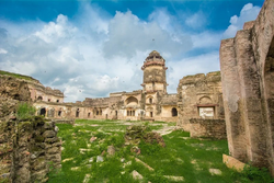
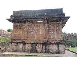
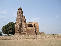
SL. No. Description Location Address District Coordinates Image N-MP-1 Commons:Category:Joda Temple, Baihar Baihar Balaghat 22°06′20″N 80°33′25″E / 22.10569°N 80.55683°E / 22.10569; 80.55683 (SL. No. N-MP-1 ) Commons:Category:Joda Temple, Baihar N-MP-2 Fort Garhi Balaghat Upload Photo N-MP-3 Commons:Category:Old fort and temples, Lanji Lanji Balaghat 21°30′00″N 80°32′38″E / 21.5°N 80.54396°E / 21.5; 80.54396 (SL. No. N-MP-3 ) Commons:Category:Old fort and temples, Lanji N-MP-4 An old temple within the limits of Piparwara forest Village Raigarh Balaghat Upload Photo N-MP-5 Commons:Category:Koteshwar Mahadev Temple, Lanji Lanji Balaghat 21°30′39″N 80°33′13″E / 21.51087°N 80.55365°E / 21.51087; 80.55365 (SL. No. N-MP-5 ) Commons:Category:Koteshwar Mahadev Temple, Lanji N-MP-6 53 images locally knows known as Sada Bhada Sonkhar Balaghat [[File:Video of Sada Bhada |150x150px|center|border|53 images locally knows known as Sada Bhada]] N-MP-7 Brick Temples (two) Kherat Bhind 26°43′49″N 78°35′30″E / 26.73025°N 78.59166°E / 26.73025; 78.59166 (SL. No. N-MP-7 ) Upload Photo N-MP-8 Open Air Museum Kherat Bhind Upload Photo N-MP-9 Ater Fort Ater Bhind 26°44′52″N 78°38′14″E / 26.74791°N 78.63721°E / 26.74791; 78.63721 (SL. No. N-MP-9 ) Ater Fort N-MP-11 Chausath Yogini Temple Khajuraho Chhatarpur 24°50′59″N 79°55′05″E / 24.84969°N 79.91815°E / 24.84969; 79.91815 (SL. No. N-MP-11 ) Chausath Yogini Temple N-MP-12 Chitragupta temple Khajuraho Chhatarpur 24°51′16″N 79°55′12″E / 24.85432°N 79.92011°E / 24.85432; 79.92011 (SL. No. N-MP-12 ) Chitragupta temple N-MP-13 Chopra or square tank Khajuraho Chhatarpur 24°51′22″N 79°55′10″E / 24.856°N 79.91952°E / 24.856; 79.91952 (SL. No. N-MP-13 ) Chopra or square tank N-MP-14 Devi Jagadambi Temple Khajuraho Chhatarpur 24°51′12″N 79°55′11″E / 24.85336°N 79.91974°E / 24.85336; 79.91974 (SL. No. N-MP-14 ) Devi Jagadambi Temple N-MP-15 Kandariya temple Khajuraho Chhatarpur 24°51′11″N 79°55′11″E / 24.85302°N 79.91968°E / 24.85302; 79.91968 (SL. No. N-MP-15 ) Kandariya temple N-MP-16 Lakshman temple Khajuraho Chhatarpur 24°51′08″N 79°55′18″E / 24.85218°N 79.92178°E / 24.85218; 79.92178 (SL. No. N-MP-16 ) Lakshman temple More images N-MP-17 Lalguan Mahadeva temple Khajuraho Chhatarpur 24°51′03″N 79°54′41″E / 24.8508°N 79.91133°E / 24.8508; 79.91133 (SL. No. N-MP-17 ) Lalguan Mahadeva temple N-MP-18 Commons:Category:Pratapesvara Temple, Khajuraho Khajuraho Chhatarpur 24°51′10″N 79°55′21″E / 24.85286°N 79.92253°E / 24.85286; 79.92253 (SL. No. N-MP-18 ) Commons:Category:Pratapesvara Temple, Khajuraho N-MP-19 Matangeswara Temple Khajuraho Chhatarpur 24°51′07″N 79°55′18″E / 24.85197°N 79.92163°E / 24.85197; 79.92163 (SL. No. N-MP-19 ) Matangeswara Temple N-MP-20 Nandi Temple Khajuraho Chhatarpur 24°51′12″N 79°55′22″E / 24.85335°N 79.92278°E / 24.85335; 79.92278 (SL. No. N-MP-20 ) Nandi Temple N-MP-21 Parvati Temple Khajuraho Chhatarpur 24°51′12″N 79°55′19″E / 24.85321°N 79.922°E / 24.85321; 79.922 (SL. No. N-MP-21 ) Parvati Temple N-MP-22 Varaha Temple Khajuraho Chhatarpur 24°51′07″N 79°55′20″E / 24.85205°N 79.92228°E / 24.85205; 79.92228 (SL. No. N-MP-22 ) Varaha Temple N-MP-23 Vishvanath Temple Khajuraho Chhatarpur 24°51′12″N 79°55′21″E / 24.85327°N 79.92252°E / 24.85327; 79.92252 (SL. No. N-MP-23 ) Vishvanath Temple N-MP-24 Adinath Temple Khajuraho Chhatarpur 24°50′42″N 79°56′12″E / 24.84513°N 79.93657°E / 24.84513; 79.93657 (SL. No. N-MP-24 ) Adinath Temple N-MP-25 Brahma Temple Khajuraho Chhatarpur 24°50′57″N 79°55′58″E / 24.84915°N 79.93277°E / 24.84915; 79.93277 (SL. No. N-MP-25 ) Brahma Temple N-MP-26 Colossal statue of Shri Hanuman Khajuraho Chhatarpur 24°51′00″N 79°55′43″E / 24.85°N 79.92859°E / 24.85; 79.92859 (SL. No. N-MP-26 ) Colossal statue of Shri Hanuman N-MP-27 Ghantia Temple Khajuraho Chhatarpur 24°50′46″N 79°56′00″E / 24.8461°N 79.93344°E / 24.8461; 79.93344 (SL. No. N-MP-27 ) Ghantia Temple N-MP-28 Khakhra Math Khajuraho Chhatarpur 24°51′13″N 79°56′52″E / 24.85353°N 79.94765°E / 24.85353; 79.94765 (SL. No. N-MP-28 ) Upload Photo N-MP-29 Parsvanatha Temple Khajuraho Chhatarpur 24°50′42″N 79°56′11″E / 24.84488°N 79.93651°E / 24.84488; 79.93651 (SL. No. N-MP-29 ) Parsvanatha Temple N-MP-30 Santinatha Temple Khajuraho Chhatarpur 24°50′41″N 79°56′10″E / 24.84462°N 79.93616°E / 24.84462; 79.93616 (SL. No. N-MP-30 ) Santinatha Temple N-MP-31 Vamana Temple Khajuraho Chhatarpur 24°51′05″N 79°56′06″E / 24.85147°N 79.93503°E / 24.85147; 79.93503 (SL. No. N-MP-31 ) Vamana Temple N-MP-32 Javari Temple Khajuraho Chhatarpur 24°50′58″N 79°56′07″E / 24.84944°N 79.93537°E / 24.84944; 79.93537 (SL. No. N-MP-32 ) Javari Temple N-MP-33 Dulhadev Shiva Temple Khajuraho Chhatarpur 24°50′20″N 79°55′55″E / 24.83902°N 79.93186°E / 24.83902; 79.93186 (SL. No. N-MP-33 ) Dulhadev Shiva Temple N-MP-34 Jatakari or Chaturbhuj Temple Khajuraho Chhatarpur 24°49′30″N 79°55′52″E / 24.8251°N 79.9311°E / 24.8251; 79.9311 (SL. No. N-MP-34 ) Jatakari or Chaturbhuj Temple N-MP-35 Inscription in the fort of Bachau Bachhaon Chhatarpur Upload Photo N-MP-36 Temple remains and mounds at Bijamandal Jatkara near Khajuraho Chhatarpur 24°49′46″N 79°56′04″E / 24.82932°N 79.9344°E / 24.82932; 79.9344 (SL. No. N-MP-36 ) Temple remains and mounds at Bijamandal N-MP-37 Deogarh Fort Deogarh Chhindwara 21°52′58″N 78°43′58″E / 21.88273°N 78.73288°E / 21.88273; 78.73288 (SL. No. N-MP-37 ) Deogarh Fort N-MP-38 Nohta ( Mahadeva ) Temple Nohta Damoh 23°40′18″N 79°34′53″E / 23.67162°N 79.58132°E / 23.67162; 79.58132 (SL. No. N-MP-38 ) Nohta ( Mahadeva ) Temple N-MP-39 Rajnagar ( Ruined ) Fort Rajnagar Damoh 23°48′04″N 79°28′36″E / 23.80101°N 79.47665°E / 23.80101; 79.47665 (SL. No. N-MP-39 ) Upload Photo N-MP-40 Rangmahal Palace Hatta Damoh 24°07′47″N 79°35′42″E / 24.12973°N 79.59499°E / 24.12973; 79.59499 (SL. No. N-MP-40 ) Upload Photo N-MP-41 (Siva) Temple of Bari Kanoda Bari Kanoda Damoh 24°16′31″N 79°26′15″E / 24.27526°N 79.43738°E / 24.27526; 79.43738 (SL. No. N-MP-41 ) Upload Photo N-MP-42 Jata Shankar Fort Jatashankar Damoh 23°49′23″N 79°26′57″E / 23.82312°N 79.44916°E / 23.82312; 79.44916 (SL. No. N-MP-42 ) Upload Photo N-MP-43 Matha at Raneh Raneh Damoh Upload Photo N-MP-44 (Siva Temple) Old Temple Kodal Damoh 23°19′50″N 79°23′03″E / 23.33067°N 79.38403°E / 23.33067; 79.38403 (SL. No. N-MP-44 ) Upload Photo N-MP-45 The remains of an old sculptures temple built without mortar and attributed to Chandelas Kanoda(Konora) Damoh Upload Photo N-MP-46 A hill Fort Singorgarh Damoh 23°32′07″N 79°45′06″E / 23.53529°N 79.75167°E / 23.53529; 79.75167 (SL. No. N-MP-46 ) Upload Photo N-MP-47 Ruined Fort Madiyado Damoh 24°16′41″N 79°39′19″E / 24.27795°N 79.6552°E / 24.27795; 79.6552 (SL. No. N-MP-47 ) Upload Photo N-MP-48 Commons:Category:Shiva Temple, Sakor Sakour Damoh 24°12′41″N 79°42′59″E / 24.21135°N 79.71626°E / 24.21135; 79.71626 (SL. No. N-MP-48 ) Commons:Category:Shiva Temple, Sakor N-MP-49 Sculptures at Phutera tank Phutera tank Damoh 23°50′51″N 79°26′39″E / 23.84739°N 79.44426°E / 23.84739; 79.44426 (SL. No. N-MP-49 ) Upload Photo N-MP-50 Flat roofed temples below the hill Kundalpur Damoh 23°59′06″N 79°43′13″E / 23.98496°N 79.72035°E / 23.98496; 79.72035 (SL. No. N-MP-50 ) Flat roofed temples below the hill N-MP-51 Jain Temples on Hill No.1 to No. 58 Kundalpur Damoh 23°59′00″N 79°43′13″E / 23.98323°N 79.72032°E / 23.98323; 79.72032 (SL. No. N-MP-51 ) Jain Temples on Hill No.1 to No. 58 N-MP-52 Beer Singh Palace Datia Datia 25°40′15″N 78°27′03″E / 25.67097°N 78.45094°E / 25.67097; 78.45094 (SL. No. N-MP-52 ) Beer Singh Palace N-MP-53 Commons:Category:Ashoka Minor Rock Edict, Gujarra Gujjara Datia 25°34′37″N 78°32′45″E / 25.57704°N 78.54587°E / 25.57704; 78.54587 (SL. No. N-MP-53 ) Commons:Category:Ashoka Minor Rock Edict, Gujarra N-MP-122 Commons:Category:Budhi Chanderi ruins Jains temple No. 1 to 5 Budhichanderi Ashok Nagar 24°48′20″N 78°04′50″E / 24.80542°N 78.08066°E / 24.80542; 78.08066 (SL. No. N-MP-122 ) Commons:Category:Budhi Chanderi ruins Jains temple No. 1 to 5 N-MP-123 Chanderi Fort Chanderi Ashok Nagar 24°42′38″N 78°08′22″E / 24.71053°N 78.13955°E / 24.71053; 78.13955 (SL. No. N-MP-123 ) Chanderi Fort N-MP-124 Bada Madarsa Chanderi Ashok Nagar 24°43′36″N 78°07′48″E / 24.72662°N 78.13011°E / 24.72662; 78.13011 (SL. No. N-MP-124 ) Upload Photo N-MP-125 Battisi Baoli Chanderi Ashok Nagar 24°43′39″N 78°07′30″E / 24.72761°N 78.12513°E / 24.72761; 78.12513 (SL. No. N-MP-125 ) Upload Photo N-MP-126 Badal Mahal Gateway Chanderi Ashok Nagar 24°42′38″N 78°08′12″E / 24.71052°N 78.13662°E / 24.71052; 78.13662 (SL. No. N-MP-126 ) Badal Mahal Gateway N-MP-127 Jama Masjid Chanderi Ashok Nagar 24°42′37″N 78°08′07″E / 24.71026°N 78.13515°E / 24.71026; 78.13515 (SL. No. N-MP-127 ) Jama Masjid N-MP-128 Kati Ghati Chanderi Ashok Nagar 24°41′48″N 78°07′55″E / 24.69669°N 78.13203°E / 24.69669; 78.13203 (SL. No. N-MP-128 ) Kati Ghati N-MP-129 Koshak Mahal Chanderi Ashok Nagar 24°41′59″N 78°06′25″E / 24.69975°N 78.10684°E / 24.69975; 78.10684 (SL. No. N-MP-129 ) Koshak Mahal N-MP-130 Tomb of Nizam-ud-din's Chanderi Ashok Nagar 24°42′41″N 78°08′12″E / 24.71147°N 78.13658°E / 24.71147; 78.13658 (SL. No. N-MP-130 ) Tomb of Nizam-ud-din's N-MP-131 Shahzadi ka Roza Chanderi Ashok Nagar 24°43′11″N 78°08′01″E / 24.71983°N 78.13353°E / 24.71983; 78.13353 (SL. No. N-MP-131 ) Shahzadi ka Roza N-MP-132 Monastery Commons:Category:Kadwaya, Madhya Pradesh Kadwaha Ashok Nagar Monastery N-MP-133 Temple No . 2 to 7 Commons:Category:Kadwaya, Madhya Pradesh Kadwaha Ashok Nagar 24°57′49″N 77°54′46″E / 24.96353°N 77.91277°E / 24.96353; 77.91277 (SL. No. N-MP-133 ) Temple No . 2 to 7 N-MP-134 Loose Sculptures Thubon Ashok Nagar 24°39′43″N 77°59′38″E / 24.66189°N 77.99381°E / 24.66189; 77.99381 (SL. No. N-MP-134 ) Loose Sculptures N-MP-135 Sitamarhi Group of Temples Thoban, Tehsil Chanderi Ashok Nagar 24°38′58″N 77°59′32″E / 24.64946°N 77.99219°E / 24.64946; 77.99219 (SL. No. N-MP-135 ) Sitamarhi Group of Temples N-MP-136 Hanuman Marhi Group of Temples Thoban, Tehsil Chanderi Ashok Nagar 24°39′30″N 77°59′48″E / 24.65825°N 77.99668°E / 24.65825; 77.99668 (SL. No. N-MP-136 ) Hanuman Marhi Group of Temples N-MP-137 Hori ki Marhia Group of Temples Thoban, Tehsil Chanderi Ashok Nagar 24°39′47″N 77°59′59″E / 24.66306°N 77.99984°E / 24.66306; 77.99984 (SL. No. N-MP-137 ) Hori ki Marhia Group of Temples N-MP-138 Gargaj and Mahadev Ghat Group of Temples Thoban, Tehsil Chanderi Ashok Nagar 24°39′38″N 77°59′27″E / 24.66059°N 77.99085°E / 24.66059; 77.99085 (SL. No. N-MP-138 ) Gargaj and Mahadev Ghat Group of Temples N-MP-139 Kuti Group of Temples Thoban, Tehsil Chanderi Ashok Nagar 24°39′49″N 77°59′35″E / 24.66348°N 77.99303°E / 24.66348; 77.99303 (SL. No. N-MP-139 ) Kuti Group of Temples N-MP-140 Andhakuan Group of Temples Thoban, Tehsil Chanderi Ashok Nagar 24°39′59″N 77°59′45″E / 24.66632°N 77.99577°E / 24.66632; 77.99577 (SL. No. N-MP-140 ) Andhakuan Group of Temples N-MP-154 Commons:Category:Vishnu Varah Temple, Karitalai Statue of a boar (Vishnu : Varah), an image of Mahadeo and figures of other Hindu & Jain Gods scattered over four Tumuli and under a Bargat tree Karitalai Katni 24°03′37″N 80°43′33″E / 24.06025°N 80.72579°E / 24.06025; 80.72579 (SL. No. N-MP-154 ) Commons:Category:Vishnu Varah Temple, Karitalai Statue of a boar (Vishnu : Varah), an image of Mahadeo and figures of other Hindu & Jain Gods scattered over four Tumuli and under a Bargat tree N-MP-155 Commons:Category:Vishnu Varah Temple, Karitalai Varaha Near Karitalai Karitalai Katni 24°03′37″N 80°43′32″E / 24.06014°N 80.7256°E / 24.06014; 80.7256 (SL. No. N-MP-155 ) Commons:Category:Vishnu Varah Temple, Karitalai Varaha Near Karitalai N-MP-156 Commons:Category:Kachch Machch statues, Karitalai Tortoise and fish; known as Kachha and Maccha Karitalai Katni 24°03′14″N 80°42′25″E / 24.05386°N 80.70689°E / 24.05386; 80.70689 (SL. No. N-MP-156 ) Commons:Category:Kachch Machch statues, Karitalai Tortoise and fish; known as Kachha and Maccha N-MP-157 Commons:Category:Tigawa Temple The whole site of Kankali Devi Temple and Durgadevi temple Tigawa Katni 23°41′26″N 80°04′00″E / 23.69059°N 80.06655°E / 23.69059; 80.06655 (SL. No. N-MP-157 ) Commons:Category:Tigawa Temple The whole site of Kankali Devi Temple and Durgadevi temple N-MP-158 Commons:Category:Vishnu Varaha temple, Bilhari Vishnu-Varaha Temple Bilhari Katni 23°47′29″N 80°16′27″E / 23.79147°N 80.27425°E / 23.79147; 80.27425 (SL. No. N-MP-158 ) Commons:Category:Vishnu Varaha temple, Bilhari Vishnu-Varaha Temple N-MP-159 Commons:Category:Tapasi Matha, Bilhari Tapsi-Math Bilhari Katni 23°47′33″N 80°16′18″E / 23.79254°N 80.27157°E / 23.79254; 80.27157 (SL. No. N-MP-159 ) Commons:Category:Tapasi Matha, Bilhari Tapsi-Math N-MP-160 Madan Mahal on the top of hill upon a large boulder rock Garha Jabalpur 23°08′54″N 79°54′06″E / 23.14832°N 79.90165°E / 23.14832; 79.90165 (SL. No. N-MP-160 ) Madan Mahal on the top of hill upon a large boulder rock N-MP-161 Temple of Somnath and ruins of several temples Badgaon Katni 23°55′06″N 80°01′07″E / 23.91841°N 80.01861°E / 23.91841; 80.01861 (SL. No. N-MP-161 ) Upload Photo N-MP-162 Rock edict of Ashoka, Rupnath Padariya Katni 23°38′26″N 80°01′56″E / 23.64067°N 80.03214°E / 23.64067; 80.03214 (SL. No. N-MP-162 ) Rock edict of Ashoka, Rupnath N-MP-163 Ruined temple near the sources of the Kiyan river Marha Deori Katni 23°55′59″N 80°15′13″E / 23.93305°N 80.25375°E / 23.93305; 80.25375 (SL. No. N-MP-163 ) Upload Photo N-MP-164 Shiva Temple on a carved stone chabutra measuring 10' x 10'x 4' and 8 stone Jain Images Nanhwara Katni Upload Photo N-MP-165 Karanbel at Tripur Sundri Temple Tewar Jabalpur 23°08′49″N 79°49′07″E / 23.14689°N 79.8186°E / 23.14689; 79.8186 (SL. No. N-MP-165 ) Upload Photo N-MP-166 Temple of Gauri Shankar within the Chausath Yogini Bheraghat Jabalpur 23°07′47″N 79°48′05″E / 23.12972°N 79.80142°E / 23.12972; 79.80142 (SL. No. N-MP-166 ) Temple of Gauri Shankar within the Chausath Yogini N-MP-167 Temple of Chausath Yogini Bheraghat Jabalpur 23°07′47″N 79°48′05″E / 23.12976°N 79.80148°E / 23.12976; 79.80148 (SL. No. N-MP-167 ) Temple of Chausath Yogini N-MP-168 Large effiggy on Vishnu Varaha Panagarh Jabalpur Upload Photo N-MP-169 Ancient Mound Kakarehta Jabalpur Upload Photo N-MP-170 Ladaki Ka Tila Bilhari Katni Upload Photo N-MP-171 Rinmukteswara Temple Kukaramath Dindori 22°51′54″N 81°09′58″E / 22.86495°N 81.16623°E / 22.86495; 81.16623 (SL. No. N-MP-171 ) Rinmukteswara Temple N-MP-172 Gond fort called Satkhanda and the tower on Rajghat called Shahburja and the Rajrajeshwari temple inside the fort Mandla Mandla 22°35′16″N 80°22′11″E / 22.58765°N 80.36964°E / 22.58765; 80.36964 (SL. No. N-MP-172 ) Upload Photo N-MP-173 Begum Mahal Chaugaon Mandla 22°37′33″N 80°31′39″E / 22.62579°N 80.5274°E / 22.62579; 80.5274 (SL. No. N-MP-173 ) Begum Mahal N-MP-174 Sporting Palace by name Dal-Badal Chaugaon Mandla 22°37′31″N 80°31′08″E / 22.62528°N 80.51882°E / 22.62528; 80.51882 (SL. No. N-MP-174 ) Upload Photo N-MP-175 Shiva's temple Khardeori Mandla 22°34′48″N 80°24′24″E / 22.57994°N 80.4066°E / 22.57994; 80.4066 (SL. No. N-MP-175 ) Upload Photo N-MP-214 Ajaigarh fort and its remains Ajaigarh Panna 24°53′40″N 80°15′54″E / 24.89454°N 80.26513°E / 24.89454; 80.26513 (SL. No. N-MP-214 ) Ajaigarh fort and its remains N-MP-215 Two termples ascribed to Gupta period Ajaigarh Panna 24°53′22″N 80°16′11″E / 24.88953°N 80.26974°E / 24.88953; 80.26974 (SL. No. N-MP-215 ) Two termples ascribed to Gupta period N-MP-216 Parvati temple Nachna Panna 24°23′57″N 80°26′52″E / 24.39916°N 80.44766°E / 24.39916; 80.44766 (SL. No. N-MP-216 ) Parvati temple N-MP-217 Chaumukhnath temple Nachna Panna 24°23′58″N 80°26′50″E / 24.3994°N 80.44725°E / 24.3994; 80.44725 (SL. No. N-MP-217 ) Chaumukhnath temple N-MP-218 i. Bhojeshwar temple , ii. Ancient Rock Engravings Bhojpur Raisen 23°06′05″N 77°34′45″E / 23.101267°N 77.579237°E / 23.101267; 77.579237 (SL. No. N-MP-218 ) i. Bhojeshwar temple , ii. Ancient Rock Engravings N-MP-219 Fort (including walls Gates and other ruins monuments in the fort) Raisen Raisen 23°19′31″N 77°46′23″E / 23.32541°N 77.7731°E / 23.32541; 77.7731 (SL. No. N-MP-219 ) Fort (including walls Gates and other ruins monuments in the fort) More images N-MP-220 Buddhist monuments Sanchi Raisen 23°28′47″N 77°44′25″E / 23.47963°N 77.74021°E / 23.47963; 77.74021 (SL. No. N-MP-220 ) Buddhist monuments More images N-MP-221 Buddhist stupas with adjucent land Sonari Raisen 23°25′56″N 77°39′51″E / 23.43229°N 77.6643°E / 23.43229; 77.6643 (SL. No. N-MP-221 ) Buddhist stupas with adjucent land N-MP-222 Buddhist stupas Muralkhurd Raisen 23°25′59″N 77°50′27″E / 23.43305°N 77.84095°E / 23.43305; 77.84095 (SL. No. N-MP-222 ) Buddhist stupas N-MP-223 Buddhist stupas and remains Andher Raisen 23°24′40″N 77°54′26″E / 23.41108°N 77.90712°E / 23.41108; 77.90712 (SL. No. N-MP-223 ) Buddhist stupas and remains N-MP-224 Stupa and other remains Satdhara Raisen 23°29′14″N 77°39′06″E / 23.48709°N 77.65155°E / 23.48709; 77.65155 (SL. No. N-MP-224 ) Stupa and other remains N-MP-225 Pre - historic rock shelters Bhimbetka Raisen 22°56′19″N 77°36′50″E / 22.938654°N 77.613773°E / 22.938654; 77.613773 (SL. No. N-MP-225 ) Pre - historic rock shelters N-MP-226 Inscriptions Alhaghat Rewa 24°52′44″N 81°20′25″E / 24.87883°N 81.34027°E / 24.87883; 81.34027 (SL. No. N-MP-226 ) Upload Photo N-MP-227 Fresco paintings Gahir Rewa Upload Photo N-MP-228 Gurgi & Rohunta remains Gurgi Rewa 24°29′43″N 81°25′48″E / 24.49518°N 81.42995°E / 24.49518; 81.42995 (SL. No. N-MP-228 ) Upload Photo N-MP-229 Inscription in Cave Keoti Rewa 24°49′01″N 81°27′24″E / 24.81699°N 81.45656°E / 24.81699; 81.45656 (SL. No. N-MP-229 ) Upload Photo N-MP-230 Rock Shelters with megaliths, monasteries and inscriptions Barhat Rewa 24°56′08″N 81°39′46″E / 24.93552°N 81.66272°E / 24.93552; 81.66272 (SL. No. N-MP-230 ) Rock Shelters with megaliths, monasteries and inscriptions N-MP-231 Shiva Temple Bamora Sagar 24°03′20″N 78°05′18″E / 24.05548°N 78.08832°E / 24.05548; 78.08832 (SL. No. N-MP-231 ) Shiva Temple N-MP-232 Fort Deori Kalan Sagar 23°23′25″N 79°00′58″E / 23.3902°N 79.01618°E / 23.3902; 79.01618 (SL. No. N-MP-232 ) Upload Photo N-MP-233 Fort Dhamoni Sagar 24°11′30″N 78°46′05″E / 24.19155°N 78.76812°E / 24.19155; 78.76812 (SL. No. N-MP-233 ) Fort N-MP-234 Tomb and Mosque of balijati Shah Dhamoni Sagar 24°11′54″N 78°45′21″E / 24.19831°N 78.75596°E / 24.19831; 78.75596 (SL. No. N-MP-234 ) Upload Photo N-MP-235 Rani Mahal Dhamoni Sagar 24°11′28″N 78°46′12″E / 24.19121°N 78.7699°E / 24.19121; 78.7699 (SL. No. N-MP-235 ) Upload Photo N-MP-236 Ancient site Eran and Pahlezpur Sagar 24°05′29″N 78°09′53″E / 24.09145°N 78.16486°E / 24.09145; 78.16486 (SL. No. N-MP-236 ) Ancient site N-MP-237 All structure in or connectuion with the Mahal(fort of the Dangri rulers (Shish Mahal) Garhpehra Sagar 23°54′51″N 78°43′01″E / 23.91423°N 78.71708°E / 23.91423; 78.71708 (SL. No. N-MP-237 ) All structure in or connectuion with the Mahal(fort of the Dangri rulers (Shish Mahal) N-MP-238 Fort Gaurjhamar Sagar 23°31′28″N 78°56′19″E / 23.52451°N 78.93874°E / 23.52451; 78.93874 (SL. No. N-MP-238 ) Upload Photo N-MP-239 Temple of Mahadeo or Mata Karonda Sagar 24°20′26″N 78°16′04″E / 24.34042°N 78.26767°E / 24.34042; 78.26767 (SL. No. N-MP-239 ) Upload Photo N-MP-240 Satgarh Karonda Sagar Upload Photo N-MP-241 Tomb of Panj pirs Khimlasa Sagar 24°12′22″N 78°21′48″E / 24.20604°N 78.36333°E / 24.20604; 78.36333 (SL. No. N-MP-241 ) Tomb of Panj pirs N-MP-242 The walls of the city with gate Khimlasa Sagar 24°12′15″N 78°21′49″E / 24.20403°N 78.36366°E / 24.20403; 78.36366 (SL. No. N-MP-242 ) Upload Photo N-MP-243 The walls of the citaded(fort) Khimlasa Sagar 24°12′21″N 78°21′43″E / 24.20587°N 78.36204°E / 24.20587; 78.36204 (SL. No. N-MP-243 ) Upload Photo N-MP-244 Old Mosque well, gateway of the fort and Nagina Mahal Khimlasa Sagar 24°12′22″N 78°21′45″E / 24.20608°N 78.36247°E / 24.20608; 78.36247 (SL. No. N-MP-244 ) Old Mosque well, gateway of the fort and Nagina Mahal N-MP-245 Mahadeva temple Pali Sagar 24°06′18″N 78°36′00″E / 24.1049°N 78.6°E / 24.1049; 78.6 (SL. No. N-MP-245 ) Upload Photo N-MP-246 Rahatgarh Fort including the monuments inside namely i) Two Gates, ii) Moti Mahal iii) Dargah of Gulmali Shah & three graves iv) Shish Mahal, v) Small Mosque vi) Dargah in ruins, vii) Samadhi viii)Dohla tank, ix) Ruined Palace x) Badal Mahal together with adjacent land
Rahatgarh Sagar 23°46′45″N 78°23′39″E / 23.77926°N 78.39421°E / 23.77926; 78.39421 (SL. No. N-MP-246 ) Rahatgarh Fort including the monuments inside namely i) Two Gates, ii) Moti Mahal iii) Dargah of Gulmali Shah & three graves iv) Shish Mahal, v) Small Mosque vi) Dargah in ruins, vii) Samadhi viii)Dohla tank, ix) Ruined Palace x) Badal Mahal together with adjacent land N-MP-247 Buddhist Remains Barhut Satna 24°26′49″N 80°50′46″E / 24.44691°N 80.8461°E / 24.44691; 80.8461 (SL. No. N-MP-247 ) Buddhist Remains N-MP-248 Remains (Shiv Temple) Bhumra Satna 24°25′42″N 80°38′29″E / 24.42835°N 80.64138°E / 24.42835; 80.64138 (SL. No. N-MP-248 ) Remains (Shiv Temple) N-MP-249 Durga Temple Ashta Seoni 21°56′04″N 79°48′53″E / 21.93439°N 79.81466°E / 21.93439; 79.81466 (SL. No. N-MP-249 ) Upload Photo N-MP-250 Standing Jain Image of Digamber Sect known as Nagbaba and the various fragmentary stone images and architectural stone pieces Ghansor Seoni 22°20′47″N 79°47′27″E / 22.34649°N 79.79077°E / 22.34649; 79.79077 (SL. No. N-MP-250 ) Upload Photo N-MP-251 Karna Temple Amarkantak Anuppur 22°40′16″N 81°45′29″E / 22.6711°N 81.75804°E / 22.6711; 81.75804 (SL. No. N-MP-251 ) Karna Temple N-MP-252 Siva Temple Amarkantak Anuppur 22°40′18″N 81°45′31″E / 22.67172°N 81.75857°E / 22.67172; 81.75857 (SL. No. N-MP-252 ) Siva Temple N-MP-253 Pataleswara Temple Amarkantak Anuppur 22°40′17″N 81°45′32″E / 22.67147°N 81.7589°E / 22.67147; 81.7589 (SL. No. N-MP-253 ) Pataleswara Temple N-MP-254 Caves bearing inscriptions of last Century AD Silhara Anuppur 23°08′17″N 81°57′52″E / 23.13793°N 81.96456°E / 23.13793; 81.96456 (SL. No. N-MP-254 ) Caves bearing inscriptions of last Century AD N-MP-255 Virateshwar (Virat Temple) and remains Sohagpur Shahdol 23°19′14″N 81°21′32″E / 23.32042°N 81.35881°E / 23.32042; 81.35881 (SL. No. N-MP-255 ) Virateshwar (Virat Temple) and remains N-MP-266 Siva temple& Monastery Chandrehi Sidhi 24°17′27″N 81°27′53″E / 24.29083°N 81.46477°E / 24.29083; 81.46477 (SL. No. N-MP-266 ) Siva temple& Monastery N-MP-272 Bijamandal Temple / Mosque Vidisha Vidisha 23°31′43″N 77°48′04″E / 23.5286°N 77.80114°E / 23.5286; 77.80114 (SL. No. N-MP-272 ) Bijamandal Temple / Mosque N-MP-273 Lohanji Hill Column Capital Vidisha Vidisha 23°31′37″N 77°48′52″E / 23.52688°N 77.81444°E / 23.52688; 77.81444 (SL. No. N-MP-273 ) Lohanji Hill Column Capital N-MP-274 Dashavatara temple Badoh Vidisha 23°55′25″N 78°13′32″E / 23.9236°N 78.22554°E / 23.9236; 78.22554 (SL. No. N-MP-274 ) Dashavatara temple N-MP-275 Jain temple Badoh Vidisha 23°55′25″N 78°13′12″E / 23.92366°N 78.22006°E / 23.92366; 78.22006 (SL. No. N-MP-275 ) Jain temple N-MP-276 Devi temple Badoh Vidisha 23°55′06″N 78°13′21″E / 23.91828°N 78.22248°E / 23.91828; 78.22248 (SL. No. N-MP-276 ) Devi temple N-MP-277 Ancient Site Besnagar Vidisha 23°32′57″N 77°47′59″E / 23.5492°N 77.79965°E / 23.5492; 77.79965 (SL. No. N-MP-277 ) Ancient Site N-MP-278 Heliodours Pillars locally known as Khamba Baba or Kham Baba Besnagar Vidisha 23°32′58″N 77°48′00″E / 23.54948°N 77.80008°E / 23.54948; 77.80008 (SL. No. N-MP-278 ) Heliodours Pillars locally known as Khamba Baba or Kham Baba N-MP-279 Athakamba temple Gyaraspur Vidisha 23°39′59″N 78°06′41″E / 23.66636°N 78.11148°E / 23.66636; 78.11148 (SL. No. N-MP-279 ) Athakamba temple More images N-MP-280 Hindu/Jain Temple Gyaraspur Vidisha 23°39′45″N 78°06′42″E / 23.66253°N 78.11162°E / 23.66253; 78.11162 (SL. No. N-MP-280 ) Hindu/Jain Temple More images N-MP-281 Hindola torans Gyaraspur Vidisha 23°40′00″N 78°06′57″E / 23.66673°N 78.11572°E / 23.66673; 78.11572 (SL. No. N-MP-281 ) Hindola torans More images N-MP-282 Buddhist stupa Gyaraspur Vidisha 23°39′54″N 78°05′54″E / 23.6649°N 78.09835°E / 23.6649; 78.09835 (SL. No. N-MP-282 ) Buddhist stupa N-MP-283 Mala Devi temple Gyaraspur Vidisha 23°39′31″N 78°06′49″E / 23.65871°N 78.11365°E / 23.65871; 78.11365 (SL. No. N-MP-283 ) Mala Devi temple More images N-MP-284 Bhimagaja Pathari Vidisha 23°56′11″N 78°13′16″E / 23.93648°N 78.22108°E / 23.93648; 78.22108 (SL. No. N-MP-284 ) Bhimagaja N-MP-285 Saptmatrika Caves Pathari Vidisha 23°55′32″N 78°12′43″E / 23.92544°N 78.21186°E / 23.92544; 78.21186 (SL. No. N-MP-285 ) Saptmatrika Caves N-MP-286 Caves No. 1 to 20 Udaygiri Vidisha 23°32′24″N 77°46′19″E / 23.53994°N 77.77198°E / 23.53994; 77.77198 (SL. No. N-MP-286 ) Caves No. 1 to 20 N-MP-287 Ruins of a Gupta temple on hill top Udaygiri Vidisha 23°32′22″N 77°46′17″E / 23.53945°N 77.77129°E / 23.53945; 77.77129 (SL. No. N-MP-287 ) Ruins of a Gupta temple on hill top N-MP-288 Bara Khambi Udaypur, Madhya Pradesh Vidisha 23°53′53″N 78°03′40″E / 23.89813°N 78.06104°E / 23.89813; 78.06104 (SL. No. N-MP-288 ) Upload Photo N-MP-289 Udayaswara or Nilkanthanswara Mahadeva Temple. Udaypur, Madhya Pradesh Vidisha Udayaswara or Nilkanthanswara Mahadeva Temple. 


