Baidyapur

Last updated

Baidyapur
Village
Baidyapur street.jpg
West Bengal location map.svg
Red pog.svg
Baidyapur
Location in West Bengal, India
India location map.svg
Red pog.svg
Baidyapur
Baidyapur (India)
Coordinates: 23°09′35″N88°14′45″E / 23.15972°N 88.24583°E / 23.15972; 88.24583
CountryFlag of India.svg  India
State West Bengal
District Purba Bardhaman
Elevation
12 m (39 ft)
Population
 (2011)
  Total4,065
Languages
  Official Bengali, English
Time zone UTC+5:30 (IST)
PIN
713122
Telephone code03454
Website purbabardhaman.gov.in

Baidyapur is a village in Kalna II CD block in Kalna subdivision of Purba Bardhaman district, West Bengal, India.

Contents

Origin of the village name

The name of this village is given in the Manasamangal Kāvya. When the daughter-in-law of Chand Soudagar, Behula, was taking her dead husband, Lakhindar, in a boat; the doctors of the village attempted to cure Lakhindar, but they failed. The doctors were called 'Baidya' in the local language, so the village was named Baidyapur.

Geography

Baidyapur
Cities and towns in the Kalna subdivision of Purba Bardhaman district
M: municipal city/ town, CT: census town, R: rural/ urban centre, H: Historical/ religious centre, C: craft centre.
Owing to space constraints in the small map, the actual locations in a larger map may vary slightly

The village is 12 meters above sea level. It has a post office, but the local police station is in Kalna. The village consists of several areas, including Rathtala, Rastala, Gholar Par and Nandipara.

Education

The village has 2 primary schools, 2 higher secondary schools and a school for the deaf and dumb. One of the higher secondary schools, Baidyapur Ramkrishna Vidyapith, is over 100 years old, the other Higher Secondary School is Baidyapur Rajrajeswar Girls' High School. The primary schools are Ranjan Club & Basic School. The school for the deaf & dumb is Baidyapur Bikash Bharati Muk Badhir Pratibandhi Vidyalaya.

Transport

Boinchi is the nearest railway station of Baidyapur. Boinchi-Kalna road passed through middle of this village.

Demographics

As per the 2011 Census of India Baidyapur had a total population of 4,065, of which 2,049 (50%) were males and 2,016 (50%) were females. Population below 6 years was 335. The total number of literates in Baidyapur was 3,134 (84.02% of the population over 6 years). [1]

Culture

The main festivals of this village are Rathyatra and Saraswati Puja. Narkeldanga, a village on the outskirts of Baidyapur celebrates Jagatgouri Jhanpan.

The main places of worship in Baidyapur are: the navaratna (nine towers) temple of Vrindaban Chandra, the Shiva temple of the Nandi family and the Shalagram Shila of Raj Rajeswar. [2]

David J. McCutchion mentions the Bengal deul (1598) with terracotta designs on four sides, the Jora Shiva temple and Shiva temple of the Nandi family (1802) with rich terracotta façade, the straight corniced navaratna temple (1845) of Vrindavana Chandra with plaster festoons and the brick-built, ridged twin deul Krishna temple (1598) with rich terracotta on all sides. He also mentions the navaratna dolmancha with ‘baroque’ vase turrets at Amdabad, near Baidyapur. [3]

According to the List of Monuments of National Importance in West Bengal the two ancient temples (joined together) at Baidyapur or Baidyapur Jora Deul is a monument of national importance. [4]

Healthcare

There is a primary health centre at Baidyapur (with 15 beds). [5]

Related Research Articles

<span class="mw-page-title-main">Kalna City</span> Town in West Bengal, India

Kalna or Ambika Kalna is a town in the Purba Bardhaman district of West Bengal, India. It is the headquarter of the Kalna subdivision, situated on the western bank of the Bhāgirathi river. The town is more popularly known as Ambika Kalna, named after the goddess Kali, Maa Ambika. It has numerous historical monuments, such as the Rajbari, and 108 Shiva temples. The city of Kalna is 60 kilometres (37 mi) from Bardhaman.

<span class="mw-page-title-main">Egra</span> City in West Bengal, India

Egra is a town in Purba Medinipur district in the state of West Bengal, India. It is the headquarters of the Egra subdivision. The ancient name of Egra was "Agrapattan".

<span class="mw-page-title-main">Kharar, Ghatal</span> City in West Bengal, India

Kharar is a historical town of Ghatal and one of the oldest town in Asia. This city is located in the Ghatal Subdivision of the Indian state of West Bengal.

<span class="mw-page-title-main">Nanoor</span> Village in West Bengal, India

Nanoor, is a village in Nanoor CD block in Bolpur subdivision of Birbhum district in West Bengal. Nanoor is the birthplace of 14th century lyric poet Chandidas of Vaishnava Padavali fame. It is developing as a craft centre with NGO support. With the massacres in 2000, Nanoor was in intense media focus.

Ilambazar is a census town, with a police station, in Ilambazar CD block in Bolpur subdivision of Birbhum district in the Indian state of West Bengal. A traditional weaving and trading centre it serves as a gateway to Birbhum district.

Boinchi is a Census town located in Hooghly District in the Indian state of West Bengal. It is under Pandua Police Station in Chinsurah subdivision. The town is located approximately 71 kilometers from Kolkata via Howrah-Bardhaman Main Line. The nearest Railway Station is Bainchi railway station, which is under the Eastern Railway and a part of Kolkata Suburban Railway System.

Hasanhati is a village in Kalna II CD block in Kalna subdivision of Purba Bardhaman district in West Bengal, India.

<span class="mw-page-title-main">Debipur, West Bengal</span> Village in West Bengal, India

Debipur is a village located at Memari I block in Purba Bardhaman district. People called Debipur R.S. because there is a Railway Station. It is under Memari police station. Nearest railway station is Debipur railway station, which is under Eastern Railway and is a part of Kolkata Suburban Railway system. Debipur Railway Station is located in Alipur. Nearest towns near Debipur are Memari, Boinchi. Debipur R.S is a Post Office of many other villages like Alipur, Debipur R.S., Mobarakpur. There is two High School and many primary schools

Patrasayer is a village in the Patrasayer CD block in the Bishnupur subdivision of the Bankura district in the state of West Bengal, India.

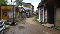
Singarkone is a village in Kalna II CD block in Kalna subdivision of Purba Bardhaman district in the state of West Bengal, India.

Mankar is a village in Galsi I CD Block in Bardhaman Sadar North subdivision of Purba Bardhaman district in the state of West Bengal, India.

Hatgobindapur is a village in Burdwan II CD block in Bardhaman Sadar North subdivision of Purba Bardhaman district in the state of West Bengal, India.

<span class="mw-page-title-main">Sribati</span> Village in West Bengal, India

Sribati or Sreebati is a village and gram panchayat in Katwa II CD block in the Katwa subdivision of Purba Bardhaman district of West Bengal.

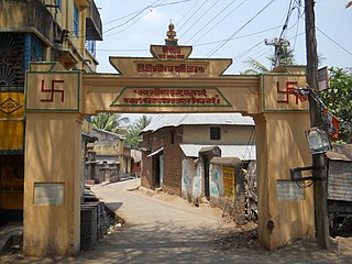
Badla is a village in Kalna II CD block in Kalna subdivision of Purba Bardhaman district in the Indian state of West Bengal.

<span class="mw-page-title-main">Supur, Birbhum</span> Village in West Bengal, India

Supur is a village under Raipur-Supur gram panchayat in Bolpur Sriniketan CD block in Bolpur subdivision of Birbhum district, West Bengal, India.

<span class="mw-page-title-main">Baidyapur Jora Deul</span> Two temples in Baidyapur

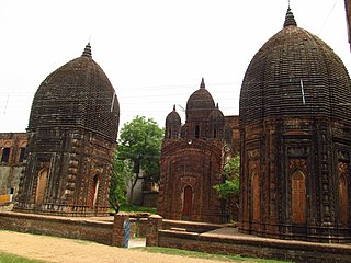
Baidyapur Jora Deul is a 16th-century temple at Baidyapur in the Kalna II CD block in the Kalna subdivision of the Purba Bardhaman district in the Indian state of West Bengal.

Gumut is a village and gram panchayat in the Bishnupur CD block in the Bishnupur subdivision of the Bankura district in the state of West Bengal, India. It includes Muninagar.

Balsi Purbapara is a village in the Patrasayer CD block in the Bishnupur subdivision of the Bankura district in the state of West Bengal, India.

Bankati is a village in Kanksa CD block in the Durgapur subdivision of the Paschim Bardhaman district in the Indian state of West Bengal.

<span class="mw-page-title-main">Bengal temple architecture</span>

Bengal temple architecture is about temple styles developed and used in Bengal, particularly the chala, ratna and dalan temples.

References

  1. "2011 Census – Primary Census Abstract Data Tables". West Bengal – District-wise. Registrar General and Census Commissioner, India. Retrieved 20 March 2017.
  2. Chattopadhyay, Akkori, Bardhaman Jelar Itihas O Lok Sanskriti (History and Folk lore of Bardhaman District.), (in Bengali), Vol II, page 608, Radical Impression, Kolkata. ISBN   81-85459-36-3
  3. McCutchion, David J., Late Mediaeval Temples of Bengal, first published 1972, reprinted 2017, pages 22, 37, 53, 54, 70, 76. The Asiatic Society, Kolkata, ISBN   978-93-81574-65-2
  4. "List of Ancient Monuments and Archaeological Sites and Remains of West Bengal - Archaeological Survey of India". Item no. 46. ASI. Retrieved 25 January 2020.
  5. "Health & Family Welfare Department". Health Statistics. Government of West Bengal. Archived from the original on 28 October 2021. Retrieved 21 March 2019.