Dhatrigram | |
|---|---|
Census Town | |
 Dhatrigram Location in West Bengal, India  Dhatrigram Dhatrigram (India) | |
| Coordinates: 23°17′44″N88°18′48″E / 23.2956°N 88.3134°E | |
| Country | |
| State | West Bengal |
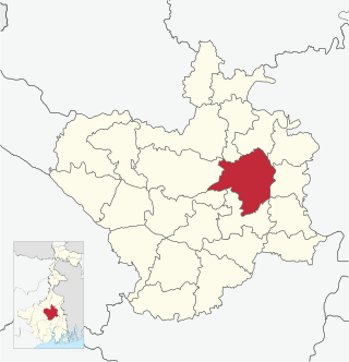
| District | Purba Bardhaman |
| Area | |
| • Total | 2.6 km2 (1.0 sq mi) |
| Population (2011) | |
| • Total | 9,951 |
| • Density | 3,800/km2 (9,900/sq mi) |
| Languages | |
| • Official | Bengali, English |
| Time zone | UTC+5:30 (IST) |
| PIN | 713405 |
| Vehicle registration | WB |
| Website | purbabardhaman |
Dhatrigram is a census town in Kalna I CD Block in Kalna subdivision of Purba Bardhaman district in the state of West Bengal, India.
Contents
- History
- Geography
- Location
- Urbanisation
- Demographics
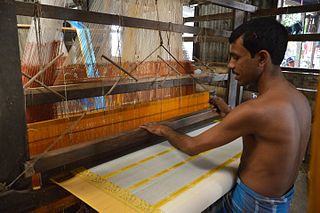
- Economy
- Infrastructure
- Transport
- Education
- Culture
- External links
- References
I have always known that usually some story of gods or kings is associated with it. However, it is now a prosperous village. In the past, it was connected to Kalna through the Bhagirathi Teer Waddel Road. In the village of Bhawanipur (Goswami Bari) adjacent to Dhatrigram, there was a Guru Bari of Raja Tej Chandra and this Guru family still resides there. In their family, the very ancient Radha Ballabh Thakur of that period is worshipped.[1]
Sri Sukumar Sen says that Dhaigaon (Dharya Gram) was the sub-capital of Lakshmana Sen ('Upkarika' - a Kachari house in the language of the present-day zamindari). On the other hand, according to Zakaria Saheb, Dharya Gram was a Jayaskandhabar. And this Jayaskandhabar means an army camp. Now if Upkarika is a sub-capital, then Upkarika and Jayaskandhabar have roughly the same meaning.
But the question arises here that is Dharyagram Dhatrigram (Dhaigaon)?
It is known from the Madhai Nagar copperplate inscription that on the 27th day of the month of Shravan (11 August 1203 AD), while staying near a place called Dharyagram, Maharaja Lakshana Sen donated land to a Brahmin named Govinda Devvarma on the occasion of the 'Aindri Mahashanti' ceremony at a place called 'Dharyagram' near 'Pundrabardhana Bhukti', 'Kantapur' within 'Barendra Bhoomi'. In this case, it is seen that he stayed near a place called 'Dharyagram', but not in Dharyagram.
Now it can be said that where Dharyagram is not Dhatrigram (Dhaigaon), “Dhatrigram has been transformed from Dhatrigram to Dhaigaon or a corruption of Dhatrigram” – this opinion of Dr. Sukumar Sen becomes baseless.
Now the question is, Goddess Jagaddhatri is established in this village, but is the village named Dhatrigram after her name?
Actually, it was a village of Dhatri-Dai. In this sense, the place was named Dhatrigram (Dhaigaon). This seems more reasonable. Again, a recent researcher has removed the meaning of the word ‘Dhatri’ from ‘Bahera=Boyara’ and found that the place was a forest of ‘Bahera’ trees, in this sense, the name of this place was Dhatrigram. He has tried to establish this opinion.