Shashpur

Last updated

Shashpur
Census Town
West Bengal location map.svg
Red pog.svg
Shashpur
Location in West Bengal, India
India location map 3.png
Red pog.svg
Shashpur
Shashpur (India)
Coordinates: 23°12′45″N88°22′46″E / 23.2126°N 88.3794°E / 23.2126; 88.3794 Coordinates: 23°12′45″N88°22′46″E / 23.2126°N 88.3794°E / 23.2126; 88.3794
CountryFlag of India.svg  India
State West Bengal
District Purba Bardhaman
Area
  Total2.42 km2 (0.93 sq mi)
Population
 (2011)
  Total10,100
  Density4,200/km2 (11,000/sq mi)
Languages
  Official Bengali, English
Time zone UTC+5:30 (IST)
Vehicle registration WB
Lok Sabha constituency Bardhaman Purba
Vidhan Sabha constituency Purbasthali Dakshin
Website purbabardhaman.gov.in

Shashpur is a census town in Kalna II CD Block in Kalna subdivision of Purba Bardhaman district in the Indian state of West Bengal.

Contents

Geography

Cities and towns in the Kalna subdivision of Purba Bardhaman district
M: municipal city/ town, CT: census town, R: rural/ urban centre, H: historical/ religious centre, C: craft centre.
Owing to space constraints in the small map, the actual locations in a larger map may vary slightly

Location

Shashpur is located at 23°12′45″N88°22′46″E / 23.2126°N 88.3794°E / 23.2126; 88.3794 .

Shashpur is also shown in the map of Kalna II CD block in the District Census Handbook. [1]

Urbanisation

87.00% of the population of Kalna subdivision live in the rural areas. Only 13.00% of the population live in the urban areas. [2] The map alongside presents some of the notable locations in the subdivision. All places marked in the map are linked in the larger full screen map.

Demographics

As per the 2011 Census of India, Shashpur had a total population of 10,100 of which 5,240 (52%) were males and 4,860 (48%) were females. Population below 6 years was 1,071. The total number of literates in Shashpur was 6,598 (73.08% of the population over 6 years). [3]

Infrastructure

As per the District Census Handbook 2011, Shashpur covered an area of 2.4249 km2. Amongst the medical facilities, the nearest nursing home was 22 km away and the nearest veterinary hospital was 22 km away. It had 4 medicine shops. It had 3 primary schools. Major educational facilities were available 1 km away at Kalna. [4]

Note: There are major medical facilities at Kalna.

Transport

Shashpur is off State Highway 6. Ambika Kalna railway station is located nearby. [5]

Related Research Articles

Gangpur is a census town in Burdwan II CD Block in Bardhaman Sadar North subdivision of Purba Bardhaman district in West Bengal, India.

Dhatrigram is a census town in Kalna I CD Block in Kalna subdivision of Purba Bardhaman district in the state of West Bengal, India.

Gopinathpur is a census town in Purbasthali I CD Block in Kalna subdivision of Purba Bardhaman district in the Indian state of West Bengal.

Hatsimla is a census town in Purbasthali I CD Block in Kalna subdivision of Purba Bardhaman district in the Indian state of West Bengal.

Panuhat is a census town in Katwa I CD Block of Katwa subdivision in Purba Bardhaman district in the Indian state of West Bengal.

<span class="mw-page-title-main">Phulia</span> Census Town in West Bengal, India

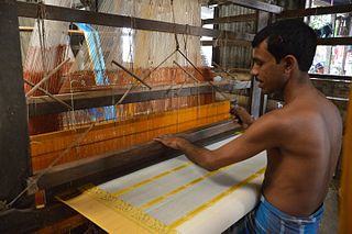
Phulia is a census town in the Santipur CD block of the Ranaghat subdivision in the Nadia district in the Indian state of West Bengal. It is birthplace of 'Adi kavi' of Bengal Krittibas Ojha.

Srirampur is a census town in Purbasthali I CD Block in Kalna subdivision of Purba Bardhaman in the Indian state of West Bengal.

Uttar Goara is a census town in Kalna I CD Block in Kalna subdivision of Purba Bardhaman district in the Indian state of West Bengal.

Dakshin Khanda is a census town in the Andal CD block in the Durgapur subdivision of the Paschim Bardhaman district in the Indian state of West Bengal.

Mirzapur is a census town in Burdwan I CD Block in Bardhaman Sadar North subdivision of Purba Bardhaman district in the state of West Bengal, India.

Arra is a census town in the Kanksa CD block in the Durgapur subdivision of the Paschim Bardhaman district in the Indian state of West Bengal.

Amlajora is a census town in the Kanksa CD block in the Durgapur subdivision of the Paschim Bardhaman district in the Indian state of West Bengal.

Goda is a census town in Burdwan I CD Block in Bardhaman Sadar North subdivision of Purba Bardhaman district in the Indian state of West Bengal.

Bahir Sarbamangala is a census town in Burdwan I CD Block in Bardhaman Sadar North subdivision of Purba Bardhaman district in the Indian state of West Bengal.

Nari is a census town in Burdwan I CD Block in Bardhaman Sadar North subdivision of Purba Bardhaman district in the Indian state of West Bengal.

Raipur is a census town in Galsi I CD Block in Bardhaman Sadar North subdivision of Purba Bardhaman district in the Indian state of West Bengal.

Alipur is a census town in Memari I CD Block in Bardhaman Sadar South subdivision of Purba Bardhaman district in the Indian state of West Bengal.

Jaluidanga is a census town in Purbasthali I CD Block in Kalna subdivision of Purba Bardhaman district in the Indian state of West Bengal.

Nasratpur is a census town in Purbasthali I CD Block in Kalna subdivision of Purba Bardhaman district in the Indian state of West Bengal.

Piarinagar is a census town in Kalna I CD Block in Kalna subdivision of Purba Bardhaman district in the Indian state of West Bengal.

References

  1. "District Census Handbook Barddhaman, Series 20 Part XII A, Census of India 2011" (PDF). Page 895: Map of Kalna II CD Block. Directorate of Census Operations 2011. Retrieved 21 January 2019.
  2. "District Statistical Handbook 2014 Bardhaman". Table 2.2. Department of Statistics and Programme Implementation, Government of West Bengal. Retrieved 25 January 2019.
  3. "C.D. Block Wise Primary Census Abstract Data(PCA)". 2011 census: West Bengal – District-wise CD Blocks. Registrar General and Census Commissioner, India. Retrieved 21 January 2019.
  4. "District Census Handbook Bardhaman, Census of India 2011, Series 20, Part XII A" (PDF). Section II Town Directory, Statement I: Growth History, Pages 1179-1181; Statement II: Physical Aspects and Location of Towns, Pages 1188-1191; Statement III: Civic and other Amenities, Pages 1191-1195; Statement IV: Medical Facilities 2009, Pages 1196-1199; Section V: Educational, Recreational and Cultural Facilities 2009, Pages 1200-1209. Directorate of Census Operations V, West Bengal. Retrieved 3 February 2019.
  5. Google maps