Sribati

Last updated

Sribati
Village
Three Temples of Sribati.JPG
West Bengal location map.svg
Red pog.svg
Sribati
India location map 3.png
Red pog.svg
Sribati
Coordinates: 23°31′17″N88°10′43″E / 23.521280°N 88.178632°E / 23.521280; 88.178632 Coordinates: 23°31′17″N88°10′43″E / 23.521280°N 88.178632°E / 23.521280; 88.178632
CountryFlag of India.svg  India
State West Bengal
District Purba Bardhaman
CD Block Katwa II
Government
  Type Panchayati raj (India)
  BodySribati Gram Panchayat
Area
  Total186.42 ha (460.65 acres)
Elevation
18 m (59 ft)
Population
 (2011)
  Total2,656
  Density1,400/km2 (3,700/sq mi)
Time zone UTC+5:30 (IST)
PIN
713514
Website purbabardhaman.gov.in

Sribati or Sreebati is a village and gram panchayat in Katwa II CD block in the Katwa subdivision of Purba Bardhaman district of West Bengal.

Contents

Geography

Cities and towns in the Katwa subdivision of Purba Bardhaman district
M: municipal city/ town, CT: census town, R: rural/ urban centre, H: historical place/ religious and/ or cultural centre, C: craft centre.
Owing to space constraints in the small map, the actual locations in a larger map may vary slightly

Location

Sribati is located on a slightly raised plateau between the Brahmani River to the north and the Khari River to the south, at an elevation of 18 meters.

Urbanisation

88.44% of the population of Katwa subdivision live in the rural areas. Only 11.56% of the population live in the urban areas. [1] The map alongside presents some of the notable locations in the subdivision. All places marked in the map are linked in the larger full screen map.

Demographics

Sribati has a population of 2,656 of which 1,352 are males while 1,304 are females as per Population Census 2011. The population of children below the age of 6 is 314 which makes up 11.82% of total population of village. Average Sex Ratio of Sribati is 964 which is higher than West Bengal state average of 950. Child Sex Ratio for Sribati is 1026, higher than West Bengal average of 956. [2]

Many villagers are from Scheduled Castes. Schedule Castes constitute 43.15% of the total population, whereas Scheduled Tribes constitute 0.11% of the total population.

In 2011, literacy rate of Sribati was 64.35% compared to 76.26% of West Bengal. In Sribati, male literacy stands at 70.68% while female literacy rate was 57.73%. Sribati has one high school, Sribati G.K. High School, which provides education up to the tenth standard. [3]

Economy

The majority of the village is engaged in agricultural work. Out of 868 working adults in the village, 114 were cultivators (owner or co-owner) while 427 were agricultural laborers.

Government

Sribati is administered by the Sribati Gram Panchayat, led by an elected Sarpanch.

Attractions

Terracotta Temple Complex

Sribati is home to one of the best preserved Bengali terracotta temple complexes from the nineteenth century. [4] [5] The complex consists of three temples housing Shiva-lingas named: Shri Viswesara (made of black stone), Shri Bholanath (made of white marble), and Shri Chandreswar (made of black stone). [6] [7]

The oldest of the temples, dedicated to Shri Chandreswar, was built in 1802 by Smt. Bhabanicharan Chandra. It was built in the rekh-deul style of Eastern India with a single spire and a square base, and decorated with terracotta reliefs from Hindu Puranic mythology including the Dashavataras, Dasha-mahavidyas and Ramlila.

The middle temple and the third temple, dedicated to Shri Bholanath and Shri Viswesara, were built in 1836, by members of the local zamindari Chandra family, Shri Ramkanai Chandra and his wife, Annapurna Devi. The middle temple was built in the pancharatna style with five spires and decorated with terracotta interweaving Shaivite, Vaishnavite and Tantric motifs. The third temple was built in the rekh-deul style with a single spire and an octagonal base, and decorated with terracotta reliefs displaying common socio-cultural scenes of that time.

The Sribati Terracotta Temple Complex (S-WB-38) is a State Protected Monument under the Archaeological Survey of India's Kolkata circle. [8]

Other Attractions

Near the terracotta temple complex are eighteenth and nineteenth-century zamindari mansions, in various states of preservation, displaying exquisite architectural motifs representative of the colonial era in Bengal: open courtyards, hanging balconies, surrounded by up to three floors of living spaces. Many of the houses also contain a very high-ceilinged puja mandap or large hall on one side, with designs etched into the walls. One of the houses still hosts an annual Durga Puja, that has been held continuously for over 300 years. [7]

Another attraction is the Shri Shri Raghunath Jiu Mandir, established in 1705. The mandir or temple is dedicated to the kuladevata of the local zamindari Chandra family, Shri Raghunath Jiu, a form of Vishnu. The shaligram in this temple was one of the treasures looted by Maratha general, Bhaskar Pandit, in 1742 during the Maratha invasions of Bengal. [9]

Related Research Articles

<span class="mw-page-title-main">Bardhaman</span> City in West Bengal, India

Bardhaman is a city and municipality in the state of West Bengal, India. It is the headquarters of Purba Bardhaman district, having become a district capital during the period of British rule. Burdwan, an alternative name for the city, has remained in use since then.

<span class="mw-page-title-main">Kalna City</span> Town in West Bengal, India

Kalna or Ambika Kalna is a town in the Purba Bardhaman district of West Bengal, India. It is the headquarters of the Kalna subdivision, situated on the western bank of the Bhāgirathi river. The town is more popularly known as Ambika Kalna, named after the goddess Kali, Maa Ambika. It has numerous historical monuments, such as the Rajbari, and 108 Shiva temples. The city of Kalna is 60 kilometres (37 mi) from Bardhaman.

<span class="mw-page-title-main">Katwa</span> City in West Bengal, India

Katwa is a sub-divisional town and railway junction in Purba Bardhaman district of the Indian state of West Bengal. It is the headquarters of the Katwa subdivision. The town was built at the confluence of Ganga and Ajay. Katwa is a border city of three districts; Purba Bardhaman District, Nadia District and Murshidabad District.

<span class="mw-page-title-main">Barakar</span> Neighbourhood in Asansol in Paschim Bardhaman, West Bengal, India

Barakar is a neighbourhood in Asansol, Paschim Bardhaman district in the Indian state of West Bengal. It is governed by the Asansol Municipal Corporation It is situated at the border of the states of Jharkhand and West Bengal. The Grand Trunk Road passes through Barakar. The neighbourhood is located on the banks of the river Barakar.

<span class="mw-page-title-main">Bishnupur, Bankura</span> City

Bishnupur is a city and a municipality of Bishnupur district in the state of West Bengal, India. It is famous for its terracotta temples built by the Malla rulers, historic Radha Krishna temples built during 1600–1800 CE and the Baluchari sarees.

<span class="mw-page-title-main">Chandrakona</span> Town in West Bengal, India

Chandrakona is a town and a municipality in the Ghatal subdivision of Paschim Medinipur district in the state of West Bengal, India. The city is located between Ghatal and Garhbeta. The king – Chandraketu was the founder of the kingdom of Chandrakona. In Ain-E-Akbari it was mentioned as ‘Mana’.

<span class="mw-page-title-main">Ramjibanpur</span> City in West Bengal, India

Ramjibanpur is a city and a municipality in the Ghatal subdivision of the Paschim Medinipur district in the Indian state of West Bengal.

<span class="mw-page-title-main">Kharar, Ghatal</span> City in West Bengal, India

Kharar is a historical town of Ghatal and one of the oldest municipality in Asia. This city is located in the Ghatal Subdivision of the Indian state of West Bengal.

<span class="mw-page-title-main">Bahulara Ancient Temple</span>

Bahulara Ancient Temple is located in Bahulara village in the Onda II village panchayat, in the Onda CD block in the Bankura Sadar subdivision of the Bankura district in the Indian state of West Bengal. It is 5 km (3.1 mi) from Ondagram railway station and 25 km (16 mi) from Bishnupur.

Katwa subdivision is an administrative subdivision of the Purba Bardhaman district in the state of West Bengal, India.

<span class="mw-page-title-main">Srikhanda</span> Village in West Bengal, India

Srikhanda is a village in Srikhanda gram panchayat in Katwa I CD block in Katwa subdivision of Purba Bardhaman district. It is about 8 km (5.0 mi) distance from Katwa and 48 km (30 mi) distance from Burdwan.

Katwa II is a community development block that forms an administrative division in Katwa subdivision of Purba Bardhaman district in the Indian state of West Bengal.

Sribati G.K. High School is a government high school located in Sribati, Katwa II, Bardhaman District, West Bengal, India. Established in 1867, it is one of the oldest schools in the area, and offers co-educational classes up to the tenth grade. It is the only educational institution in Sribati.

<span class="mw-page-title-main">Baidyapur</span> Village in West Bengal, India

Baidyapur is a village in Kalna II CD block in Kalna subdivision of Purba Bardhaman district, West Bengal, India.

Mankar is a village in Galsi I CD Block in Bardhaman Sadar North subdivision of Purba Bardhaman district in the state of West Bengal, India.

<span class="mw-page-title-main">Purba Bardhaman district</span> District in West Bengal, India

Purba Bardhaman district is in West Bengal. Its headquarters is in Bardhaman. It was formed on 7 April 2017 after the division of the previous Bardhaman district. Great revolutionary Rash Behari Bose was born in village Subaldaha in the district of Purba Bardhaman.

Arra is a census town in the Kanksa CD block in the Durgapur subdivision of the Paschim Bardhaman district in the Indian state of West Bengal.

<span class="mw-page-title-main">Gourangapur</span> Village in West Bengal, India

Gourangapur is a village in Kanksa CD block in Durgapur subdivision of Paschim Bardhaman district in the Indian state of West Bengal. The place has links with Ichhai Ghosh, king of Gopbhum, and it is believed that his capital, Dhekur, was located nearby. The area was earlier a part of Senpahari pargana.

<span class="mw-page-title-main">Baidyapur Jora Deul</span> Two temples in Baidyapur

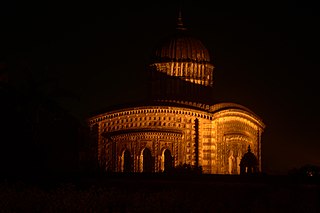
Baidyapur Jora Deul is a 16th-century temple at Baidyapur in the Kalna II CD block in the Kalna subdivision of the Purba Bardhaman district in the Indian state of West Bengal.

Balsi Purbapara is a village in the Patrasayer CD block in the Bishnupur subdivision of the Bankura district in the state of West Bengal, India.

References

  1. "District Statistical Handbook 2014 Bardhaman". Table 2.2. Department of Statistics and Programme Implementation, Government of West Bengal. Retrieved 25 January 2019.
  2. "Sribati Village Population - Katwa - II - Barddhaman, West Bengal". www.census2011.co.in. Retrieved 1 April 2018.
  3. খোঁজখবর. "আজও নাড়ু ও কলা দেওয়া হয় শ্রীবাটী গোকুলকৃষ্ণ চন্দ্র বিদ্যালয়ে | KHONJKHOBOR". khonjkhobor.in. Retrieved 1 April 2018.
  4. "The Telegraph - Calcutta (Kolkata) | Metro | Next weekend you can be at ... Sribati". www.telegraphindia.com. Archived from the original on 26 February 2010. Retrieved 2 April 2018.
  5. Katwa-কাটোয়া (30 November 2017), Sribati Terracotta Temple, Katwa,West Bengal(Incredible India) , retrieved 2 April 2018
  6. Sengupta, Somen (11 June 2017). "Sribati: Where Temples Mirror a Time" (PDF). The Hitavada. Retrieved 1 April 2018.
  7. 1 2 "Sribati ~ West Bengal's Hidden Terracotta Gem". Rangan Datta. 9 April 2013. Retrieved 2 April 2018.
  8. "List of Ancient Monuments and Archaeological Sites and Remains of Arunachal Pradesh - Archaeological Survey of India". asi.nic.in. Retrieved 2 April 2018.
  9. চন্দ্র, মহাদেব (2014). চন্দ্র বংশ ও শ্রীবাটি টেরাকোটা. অজয় আচার্য.