Bhalia

Last updated

Bhalia
Village
West Bengal location map.svg
Red pog.svg
Bhalia
Location in West Bengal, India
India location map.svg
Red pog.svg
Bhalia
Bhalia (India)
Coordinates: 22°53′47″N87°51′44″E / 22.8963°N 87.8623°E / 22.8963; 87.8623
CountryFlag of India.svg  India
State West Bengal
District Hooghly
Population
 (2011)
  Total2,452
Languages
  Official Bengali, English
Time zone UTC+5:30 (IST)
PIN
712615
Telephone/STD code03211
Lok Sabha constituency Arambagh
Vidhan Sabha constituency Arambag
Website hooghly.gov.in

Bhalia is a village in the Arambagh CD block in the Arambagh subdivision of Hooghly district in the Indian state of West Bengal.

Contents

Geography

Bhalia
This is a stopgap mapping solution, while attempts are made to resolve technical difficulties with {{ OSM Location map }}
Cities and towns in Arambagh subdivision in Hooghly district
M: municipal city/ town, R: rural/ urban centre, H: historical/ religious centre
Owing to space constraints in the small map, the actual locations in a larger map may vary slightly

Location

Bhalia is located at 22°53′47″N87°51′44″E / 22.8963°N 87.8623°E / 22.8963; 87.8623

Area overview

The Arambagh subdivision, presented in the map alongside, is divided into two physiographic parts – the Dwarakeswar River being the dividing line. The western part is upland and rocky – it is extension of the terrain of neighbouring Bankura district. The eastern part is flat alluvial plain area. The railways, the roads and flood-control measures have had an impact on the area. [1] The area is overwhelmingly rural with 94.77% of the population living in rural areas and 5.23% of the population living in urban areas. [2]

Note: The map alongside presents some of the notable locations in the subdivision. All places marked in the map are linked in the larger full screen map.

Demographics

According to the 2011 Census of India, Bhalia had a total population of 2,452 of which 1,241 (51%) were males and 1,211 (49%) were females. Population in the age range 0–6 years was 265. The total number of literate persons in Bhalia was 1,690 (77.27% of the population over 6 years). [3]

Culture

David J. McCutchion mentions the Raghunatha temple of Sarkar family as an at chala with porch on triple archway, built in 1772 and measuring 24’ x 23’. [4]

Related Research Articles

<span class="mw-page-title-main">Egra</span> City in West Bengal, India

Egra is a town in Purba Medinipur district in the state of West Bengal, India. It is the headquarters of the Egra subdivision. The ancient name of Egra was "Agrapattan".

<span class="mw-page-title-main">Kharar, Ghatal</span> City in West Bengal, India

Kharar is a historical town of Ghatal and one of the oldest town in Asia. This city is located in the Ghatal Subdivision of the Indian state of West Bengal.

Gourhati is a village in the Arambagh CD block in the Arambagh subdivision of the Hooghly district in the Indian state of West Bengal.
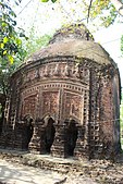
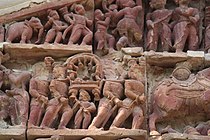
<span class="mw-page-title-main">Arambagh (community development block)</span> Community development block in West Bengal, India

Arambagh is a community development block that forms an administrative division in Arambag subdivision of Hooghly district in the Indian state of West Bengal.

Alangiri is a village in the Egra I CD block in the Egra subdivision of the Purba Medinipur district in the state of West Bengal, India.

Bali Dewanganj is a village and a gram panchayat in the Goghat I CD block in the Arambagh subdivision of Hooghly district in the Indian state of West Bengal.

Badanganj is a village in the Goghat II CD block in the Arambagh subdivision of Hooghly district in the Indian state of West Bengal.

Dihi Bayara is a village in the Arambagh CD block in the Arambagh subdivision of Hooghly district in the Indian state of West Bengal.

Hamirbati is a village in the Arambagh CD block in the Arambagh subdivision of Hooghly district in the Indian state of West Bengal.

Fului is a village in the Goghat II CD block in the Arambagh subdivision of Hooghly district in the Indian state of West Bengal.

Kayapat is a village in the Goghat II CD block in the Arambagh subdivision of Hooghly district in the Indian state of West Bengal.

Mamudpur is a village in the Goghat II CD block in the Arambagh subdivision of Hooghly district in the Indian state of West Bengal.

Memanpur is an inhabited place in the Goghat II CD block in the Arambagh subdivision of Hooghly district in the Indian state of West Bengal.

Shyambazar is a village in the Goghat II CD block in the Arambagh subdivision of Hooghly district in the Indian state of West Bengal.

Satberia is a village in the Goghat II CD block in the Arambagh subdivision of Hooghly district in the Indian state of West Bengal.

Hat Basantapur is a village in the Arambagh CD block in the Arambagh subdivision of Hooghly district in the Indian state of West Bengal.

Kanpur is a village in the Arambagh CD block in the Arambagh subdivision of Hooghly district in the Indian state of West Bengal.

Madhabpur is a village and gram panchayat in the Arambagh CD block in the Arambagh subdivision of Hooghly district in the Indian state of West Bengal.

<span class="mw-page-title-main">Parul, Hooghly</span> Village in West Bengal, India

Parul is a village in the Pursurah CD block in the Arambagh subdivision of Hooghly district in the Indian state of West Bengal.

Kotalpur is a village and a gram panchayat in the Jangipara CD block in the Srirampore subdivision of Hooghly district in the Indian state of West Bengal.

References

  1. "District Census Handbook: Hugli, Series-20, Part XIIA" (PDF). Physiography, Page 17-19. Directorate of Census Operations, West Bengal, 2011. Retrieved 25 September 2020.
  2. "District Statistical Handbook 2014 Hooghly". Table 2.2, 2.4(a). Department of Planning and Statistics, Government of West Bengal. Retrieved 25 September 2020.
  3. "2011 Census – Primary Census Abstract Data Tables". West Bengal – District-wise. Registrar General and Census Commissioner, India. Retrieved 22 September 2020.
  4. McCutchion, David J., Late Mediaeval Temples of Bengal, first published 1972, reprinted 2017, page 35. The Asiatic Society, Kolkata, ISBN   978-93-81574-65-2