Kanpur, Hooghly

Last updated

Kanpur
Village
West Bengal location map.svg
Red pog.svg
Kanpur
Location in West Bengal, India
India location map.svg
Red pog.svg
Kanpur
Kanpur (India)
Coordinates: 22°50′11″N87°49′39″E / 22.8363°N 87.8276°E / 22.8363; 87.8276
CountryFlag of India.svg  India
State West Bengal
District Hooghly
Population
 (2011)
  Total2,657
Languages
  Official Bengali, English
Time zone UTC+5:30 (IST)
PIN
712413
Telephone/STD code03211
Lok Sabha constituency Arambagh
Vidhan Sabha constituency Arambag
Website hooghly.gov.in

Kanpur is a village in the Arambagh CD block in the Arambagh subdivision of Hooghly district in the Indian state of West Bengal.

Contents

Geography

Kanpur, Hooghly
Invisible Square.svg
Mapscaleline.svg
8km
5miles
Red pog.svg
Damodar
River
Rupnarayan
River
Mundeswari
River
Dwarakeswar
River
Shyambazar
H
Invisible Square.svg
Satberia
H
Invisible Square.svg
Parul
H
Invisible Square.svg
Memanpur
H
Invisible Square.svg
Mamudpur
H
Invisible Square.svg
Madhabpur
H
Invisible Square.svg
Kanpur
HV
Kayapat
H
Invisible Square.svg
Hat Basantapur
H
Invisible Square.svg
Hamirbati
H
Invisible Square.svg
Gourhati
H
Invisible Square.svg
Fului
H
Invisible Square.svg
Dihi
Bayara
H
Invisible Square.svg
Bhalia
H
Invisible Square.svg
Bali Dewanganj
H
Invisible Square.svg
Badanganj
H
Invisible Square.svg
Gar Mandaran
H
Invisible Square.svg
Arambag
M
Invisible Square.svg
Dakshin Narayanpur
R
Invisible Square.svg
Natibpur
R
Invisible Square.svg
Shrirampur
R
Invisible Square.svg
Radhanagore
R
Invisible Square.svg
Keshabpur
R
Invisible Square.svg
Bengai
R
Invisible Square.svg
Pursurah
R
Invisible Square.svg
Kamarpukur
R
Invisible Square.svg
Khanakul
R
Invisible Square.svg
Cities and towns in Arambagh subdivision in Hooghly district
M: municipal city/ town, R: rural/ urban centre, H: historical/ religious centre
Owing to space constraints in the small map, the actual locations in a larger map may vary slightly

Location

Kanpur is located at 22°50′11″N87°49′39″E / 22.8363°N 87.8276°E / 22.8363; 87.8276

Area overview

The Arambagh subdivision, presented in the map alongside, is divided into two physiographic parts – the Dwarakeswar River being the dividing line. The western part is upland and rocky – it is extension of the terrain of neighbouring Bankura district. The eastern part is flat alluvial plain area. The railways, the roads and flood-control measures have had an impact on the area. [1] The area is overwhelmingly rural with 94.77% of the population living in rural areas and 5.23% of the population living in urban areas. [2]

Note: The map alongside presents some of the notable locations in the subdivision. All places marked in the map are linked in the larger full screen map.

Demographics

As per the 2011 Census of India, Kanpur had a total population of 2,657 of which 1,361 (51%) were males and 1,296 (49%) were females. Population in the age range 0–6 years was 260. The total number of literate persons in Kanpur was 1,967 (82.06% of the population over 6 years). [3]

Culture

David J. McCutchion mentions the Kanakesvara temple as an eka ratna with open verandah all round having arhes on wall sections He feels that such eka ratna design may have originated from the rekha deul. It is brick temple, possibly built in the 19th century, having slight plasterwork. [4]

The photographer has added a note: The Kanakeswar Shiva temple is a prominent Hindu religious centre in the area. The Gajan festival of Lord Shiva and the Kalu Rai fair are celebrated enthusiastically.

Related Research Articles

Arambagh also known as Arambag is a town and a municipality in Hooghly district in the state of West Bengal, India. It is the headquarters of Arambagh subdivision.

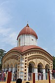
Kamarpukur is a village in the Goghat II CD block in the Arambag subdivision of the Hooghly District in West Bengal state of India. It is the birthplace of Sri Ramakrishna. It is the block headquarters of the Goghat –II community development block.

<span class="mw-page-title-main">Kharar, Ghatal</span> City in West Bengal, India

Kharar is a historical town of Ghatal and one of the oldest town in Asia. This city is located in the Ghatal Subdivision of the Indian state of West Bengal. Earlier this town was part of Hooghly District later it was merged with Medinipur district.

Bengai is a village in the Goghat II CD block in the Arambagh subdivision of the Hooghly district in the Indian state of West Bengal.

Gourhati is a village in the Arambagh CD block in the Arambagh subdivision of the Hooghly district in the Indian state of West Bengal.

Khanakul is a town in Hooghly District in the state of West Bengal, India. Khanakul is the birthplace of Raja Ramohon Roy. The town is famous for Ratnavali Temple, Gopinath Temple, Radhavallabh Temple, Ghontashor Temple. Khanakul can be reached conveniently by Bus from Kolkata or Tarakeswar. Tarakeswar Station is the nearest railway station from Khanakul. Khanakul pollution testing centre is for auto emission testing.

Bali Dewanganj is a village and a gram panchayat in the Goghat I CD block in the Arambagh subdivision of Hooghly district in the Indian state of West Bengal.

Badanganj is a village in the Goghat II CD block in the Arambagh subdivision of Hooghly district in the Indian state of West Bengal.

Bhalia is a village in the Arambagh CD block in the Arambagh subdivision of Hooghly district in the Indian state of West Bengal.

Dihi Bayara is a village in the Arambagh CD block in the Arambagh subdivision of Hooghly district in the Indian state of West Bengal.

Hamirbati is a village in the Arambagh CD block in the Arambagh subdivision of Hooghly district in the Indian state of West Bengal.

Fului is a village in the Goghat II CD block in the Arambagh subdivision of Hooghly district in the Indian state of West Bengal.

Kayapat is a village in the Goghat II CD block in the Arambagh subdivision of Hooghly district in the Indian state of West Bengal.

Mamudpur is a village in the Goghat II CD block in the Arambagh subdivision of Hooghly district in the Indian state of West Bengal.

Memanpur is an inhabited place in the Goghat II CD block in the Arambagh subdivision of Hooghly district in the Indian state of West Bengal.

Shyambazar is a village in the Goghat II CD block in the Arambagh subdivision of Hooghly district in the Indian state of West Bengal.

Satberia is a village in the Goghat II CD block in the Arambagh subdivision of Hooghly district in the Indian state of West Bengal.

Hat Basantapur is a village in the Arambagh CD block in the Arambagh subdivision of Hooghly district in the Indian state of West Bengal.

Madhabpur is a village and gram panchayat in the Arambagh CD block in the Arambagh subdivision of Hooghly district in the Indian state of West Bengal.

<span class="mw-page-title-main">Parul, Hooghly</span> Village in West Bengal, India

Parul is a village in the Pursurah CD block in the Arambagh subdivision of Hooghly district in the Indian state of West Bengal.

References

  1. "District Census Handbook: Hugli, Series-20, Part XIIA" (PDF). Physiography, Page 17-19. Directorate of Census Operations, West Bengal, 2011. Retrieved 25 September 2020.
  2. "District Statistical Handbook 2014 Hooghly". Table 2.2, 2.4(a). Department of Planning and Statistics, Government of West Bengal. Retrieved 25 September 2020.
  3. "2011 Census – Primary Census Abstract Data Tables". West Bengal – District-wise. Registrar General and Census Commissioner, India. Retrieved 22 September 2020.
  4. McCutchion, David J., Late Mediaeval Temples of Bengal, first published 1972, reprinted 2017, pages 38, 75. The Asiatic Society, Kolkata, ISBN   978-93-81574-65-2