Garh Panchkot

Last updated

Garh Panchkot
Garh Panchkot.jpg
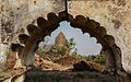
Garh Panchkot Ras Mandir
Location Flag of India.svg India
Coordinates 23°36′00″N86°46′00″E / 23.6°N 86.76667°E / 23.6; 86.76667
Area Purulia District, West Bengal
West Bengal location map.svg
Red pog.svg
Location in West Bengal, India

Garh Panchkot is a ruined fort located in the eastern part of India at the foothills of Panchet Hill in the district of Purulia, West Bengal. The ruins of the Panchkot Palace are a silent testimony to the Bargi attack during the 18th century.

Contents

History

From a historical perspective Alivardi Khan had become the Nawab of Bengal in April 1740, having defeated and killed Sarfiraz Khan. Rustam Jung, Sarfiraz's brother-in-law, challenged Alivardi Khan but failed in his endeavours which prompted him to seek the help of the Maratha Rulers of Nagpur, Raghoji Bhonsle. A Maratha cavalry was sent by Bhosle who entered Bengal through Panchet and started looting the countryside. These Maratha men came to be known as "Bargi's". For about 10 years they looted and plundered Bengal. It ended in the year 1751 after a settlement was reached between the Nawab of Bengal and Maratha King.

During one of these encounters, Garh Panchkot was attacked by the "Bargi" and, having defeated the King's guards, they destroyed it after looting and plundering the palace. It is believed that all the 17 wives of the king committed suicide in a nearby well during the attack. Garh Panchkot has lain in ruin ever since.

Geography

Garh Panchkot
Places in Raghunathpur subdivision in Purulia district
M: municipal town, CT: census town, R: rural/ urban centre, H: historical/ religious centre, T: tourist centre
Owing to space constraints in the small map, the actual locations in a larger map may vary slightly

Location

Garh Panchkot is located at 23°36′00″N86°46′00″E / 23.6°N 86.76667°E / 23.6; 86.76667 .

Note: The map alongside presents some of the notable locations in the subdivision. All places marked in the map are linked in the larger full screen map.

Fort

In the fort's construction a combination of natural and man made resources were used to build it.

A semicircular moat was built which started from one end of the foothill to the other end. The only way to enter was by crossing the moat by using a boat at the centre of the semicircle. The rest of the area was either inaccessible due to large growth of a special type of bamboo tree which grew thick wild making it very difficult for intruders as well as a thick and high stone wall that was constructed.

600 feet above in the middle of the Panchakot Hill were the guard's quarters. In contrast to the architecture of the palace below, it was completely made of large stone slabs.

The guard's quarter has a strategic position. Spread over a 500 square meters area is more of a miniature fort surrounded by solid rock walls with only one entry point, the pyramid like hollow gate from where the entire palace below and the surroundings could be watched.

Once inside the fort, on the right as well as left there are two long and narrow rooms with small vents overlooking the plains. In the centre stands a stone temple dedicated to Rama the king of Ayodhya, this signifies that it was truly a guards' quarter as more appropriately the people who guarded the area were the elite warriors and generally worshiped Rama as he represented strength, courage and one who had fought many wars. From the other remains one cannot ascertain the true nature of its usefulness; a hollow lion's head made of stone known as the "Singh Mukh" or other artefacts mostly made of stone.

Features

Temples

The king was a Awadhiya Kurmi chieftain who believed in Shaktism, although the temples reflect his inclination towards Vaishnavism. This could be due to the influence of Chaitanya Mahaprabhu, a proponent of Vaishnavism, during that period. The two distinctive architectural styles, which are evident from the temples, are the Bishnupuri style and a much older architectural style of using stone blocks. It is believed that the Bishnupuri styled temples housed Krishna and the followers were mostly vegetarians whereas the Stone Temples housed the figure of Kali and the followers were non-vegetarians and also believed in animal sacrifice. This lends credence to the fact that the King was tolerant towards other beliefs as one more Jain cave can be found in the vicinity.

There is another very old stone temple, which is dedicated to Rama. This could be because it is believed that most of the Hindu Kings of India were Raghu-Vanshis or descendants of Rama and his legendary ancestral kings as per the Hindu epic Ramayana.

Guard's quarter

At 600 feet above sea level in the middle of Panchakot Hill, the guard's quarter stands as a formidable fort.

Defense moat

The "Singha-dwar" was the only entrance to the area. Today, the moat has been reduced to a mere pond with a road running through the middle of it. A broken entrance gate for the boats is what remains of the once famous "Singh Dwar". After crossing the Singha Dwar it is about 7 km to the Palace. The curved road is through the bamboo bush, which was planted as a second line of defence. Even during the middle of the afternoon the road is dark due to the bamboo bush along the roadside.

Arms and ammunition

During those days in India, warfare was mainly fought with bows and arrows, spear, swords, daggers, cannons, etc. It was sheer strategy and numbers that mattered, not the arms. In a phased-out manner it started with sword fights. The army here consisted of foot soldiers, an infantry of horse riders, and elephants.

Palace – Rani Mahal

Not much information is available but given the arches and the pillars scattered across an area of about 20,000 sq feet, the Palace alone would have been a massive structure. As legend has it, the king had 17 wives and they all stayed in this palace lending credence to its size. The material used to build the Rani Mahal is a bit different from that of the temples and the Guard's quarter. It uses "Choon Surki" or a paste made of lime and powered clay bricks fused using water as a base to hold the fire clay bricks. This style of masonry was quite prevalent in that particular period and it still exists. The arches on the other hand mimic the Moghul architecture which indicates that the Rani Mahal was built later, possibly during the 16th century AD compared to the stone temples which are nearby.

Maratha attack

There is enough evidence that dacoits from Maharashtra came to this remote part of West Bengal during 1760.

The popular belief is that the Marathas ransacked the King's palace. Dishonored and defeated the King retreated to Kashipur.[ citation needed ]

"Borgi elo deshe khajna debo kise" is a very common phrase in the villages near Garh Panchokot which literally means – The Marathas have come to our place how will we pay the taxes![ citation needed ]

Related Research Articles

<span class="mw-page-title-main">Balaji Baji Rao</span> 8th Peshwa of the Maratha Empire (1720–1761)

Balaji Baji Rao, often referred to as Nana Saheb I, was the 8th Peshwa of the Maratha Confederacy. He was appointed as Peshwa in 1740 upon the death of his father, the Peshwa Bajirao I.

Panchet is a census town in Nirsa CD block in Dhanbad Sadar subdivision of Dhanbad district in the Indian state of Jharkhand.

<span class="mw-page-title-main">Barabati fort</span> Fort in Cuttack

Barabati Fort is a 987 CE fort built by Marakata Keshari of Somavanshi (Keshari) dynasty in Cuttack, Odisha. The ruins of the fort remain with its moat, gate, and the earthen mound of the nine-storied palace.

<span class="mw-page-title-main">Panchet Dam</span> Dam in Jharkhand and Purulia district, West Bengal

Panchet Dam was the last of the four multi-purpose dams included in the first phase of the Damodar Valley Corporation (DVC). It was constructed across the Damodar River at Panchet in Dhanbad district in the Indian state of Jharkhand, and opened in 1959.

Bargis were a light cavalry mercenary group of Maratha Empire's who indulged in large scale plundering of the countryside of western part of Bengal for about ten years (1741–1751) during the Maratha invasions of Bengal. Maratha invasions took place almost as an annual event for 10 years.

Gobag is a village in the Neturia CD block in the Raghunathpur subdivision of the Purulia district in the state of West Bengal, India.

<span class="mw-page-title-main">Munger Fort</span> Fort in Munger, Bihar, India

The Munger Fort, located at Munger, in the state of Bihar, India, is built on a rocky hillock on the south bank of the Ganges River. Its history is not completely dated but it is believed that it was built during the early rule of Slave dynasty of India. The Munger town where the fort is situated was under the control of Muhammad bin Tughluq of Delhi. The fort has two prominent hills called the Karnachaura or Karanchaura, and the other a built up rectangular mound deduced to be the location of a citadel of the fort with historical links. The fort had a succession of Muslim rulers (Khaljis, Tughlaqs, Lodis, Nawabs of Bengal, followed by Mughal rulers, till it was finally acceded to the British by Mir Quasim, after unseating his father-in-law Mīr Jafar on the grounds of old age, for a monetary reward negotiated by Vansittart. This deal involved payment by the East India Company's merchants of an ad valorem duty of 9 percent, against an Indian merchant's duty of 40%. The fort became a place of considerable importance to the British in Bengal till 1947.

Dishergarh is a neighbourhood in Asansol of Paschim Bardhaman district in the Indian state of West Bengal. It is governed by Asansol Municipal Corporation. It is situated at the border of the Purulia district and Paschim Bardhaman district in West Bengal. The State Highway 5 (SH5) passes through Dishergarh. The neighbourhood is located on the banks of Damodar River.

Para is a village, with a police station, in the Para CD block in the Raghunathpur subdivision of the Purulia district in West Bengal, India.

<span class="mw-page-title-main">Bero railway station</span> Railway station in West Bengal, India

Bero railway station serves Bero and surrounding villages in Purulia district in the Indian state of West Bengal.

<span class="mw-page-title-main">Sabalgarh Fort</span>

Sabalgarh Fort is a 16-17th-century hill fort near Sabalgarh, Madhya Pradesh, India. This fort is situated on a large rock in the northeastern part of Sabalgarh, The town was founded by Raja Sabal Singh. Presently, the fortress is in ruins and is infamous for stories of haunting and ghosts. The fort consists of a defensive structure and one main palaces and many other buildings. The fort has been controlled by a number of different rulers in its history.

<span class="mw-page-title-main">Vizianagaram Fort</span> 18th-century fort in Vizianagaram, Andhra Pradesh, South India.

Vizianagaram fort is an early 18th-century fort in the city of Vizianagaram in northeastern Andhra Pradesh, South India. It was built by Vijaya Rama Raju, the Maharaja of Vizianagaram in 1713. The formal ceremony, while laying the foundation for the fort, was very auspicious as it represented five signs of victory. The square-shaped fort has two main gates, of which the main entry gate has elaborate architectural features. There are many temples and palaces within the fort and a victory tower. This alternative name is Pusapati.

<span class="mw-page-title-main">Panchet Hill</span>

Panchet Hill, referred to in Bengali as Panchakot Pahar, is located in Neturia at the north-eastern end of Purulia district, in the Indian state of West Bengal.

Nituria is a village, with a police station, in the Neturia CD block in the Raghunathpur subdivision of the Purulia district in West Bengal, India.

<span class="mw-page-title-main">Telkupi</span>

Telkupi is a submerged location of archaeological interest in Purulia district of West Bengal, India. The area, along with most of the temples situated there, was submerged in 1959 as a consequence to the construction of a dam across Damodar river at Panchet in Dhanbad district, then in Bihar.

Sarbari is a village in West Bengal, India. It is located within Neturia CD block of Raghunathpur subdivision of Purulia district.

Harmadih is a village in the Neturia CD block in the Raghunathpur subdivision of the Purulia district in the state of West Bengal, India.

Bhaskar Ram Kolhatkar, known as Baba Bhaskar Pandit by the people of Bengal, was a Maratha general and statesman. He was the dewan of the raja of Nagpur, Raghuji Bhonsle. He played an important role in the kingdom of Nagpur's expansion. The first Maratha invasion of Bengal in 1741, as also the third in 1744, was led by him. He was an able military leader, proven by his success in the Maratha invasions of Bengal and conquest of Chhattisgarh. He was killed by Alivardi Khan on 30 March 1744.

<span class="mw-page-title-main">Maratha Ditch</span> Road in Calcutta, India

The Maratha Ditch was a 3-mile long deep entrenchment constructed by the English East India Company around Fort William in Calcutta. It was built to protect the surrounding villages and forts from the Maratha Bargi raiders. The ditch marked the outer limits of Calcutta city in the nineteenth century.

Damodar Shekhar was the first king of the Panchkot Raj family. Panchkot Raj family belonged to the Kurmi (Mahato) community.

References

Garh Panchakot