Kashipur, West Bengal

Last updated

Kashipur
Village
Kashipur Palace 07.JPG
Kashipur Rajbari
West Bengal location map.svg
Red pog.svg
Kashipur
Location in West Bengal, India
India location map.svg
Red pog.svg
Kashipur
Kashipur (India)
Coordinates: 23°26′11″N86°40′13″E / 23.43639°N 86.67028°E / 23.43639; 86.67028
CountryFlag of India.svg  India
State West Bengal
District Purulia
Subdivision Raghunathpur
Government
  Body Gram panchayat
Languages
  Official Bengali, English
Time zone UTC+5:30 (IST)
Website wb.gov.in

Kashipur is a village, with a police station, in the Kashipur CD block in the Raghunathpur subdivision of the Purulia district in West Bengal, India. Kalloli, where the CD Block headquarters are located, is close to Kashipur.

Contents

History

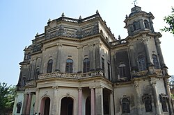
The Panchkot Raj had ruled from their capital at Garh Panchkot from 940 to 1750 AD. However, Panchkot Raj faced adversities towards the end of their stay at Garh Panchkot. Around 1600 AD the area came under the rule of Bir Hambir of the Bishnupur Malla dynasty. Not much is known about the impact of that rule. Subsequently, Bargi attacks laid waste the place. Around 1750 AD, the Panchkot Raj family shifted to Kashipur and have been here since then. [1] [2]

The Panchkot Jagir (also known as Zamindari Raj of Panchkot or Chakla Panchkot) was founded about the year 80 AD by Damodar Shekhar who belonged to the Kudmi Mahato community. [3] [4] [5] [6] [7] [8] [9] Amongst the recent members were Raja Bahadur Jyoti Prasad Singh Deo, who ruled from 1901-1938 and was granted the title of Raja as a personal distinction in 1912. Raja Kalyani Prasad Singh Deo ruled from 1938-1945, Raja Shankari Prasad Singh Deo ruled from 1945 to 1956 and Raja Bhubaneswari Prasad Singh Deo ruled from 1956-1972. [10]

Geography

Kashipur, West Bengal
Invisible Square.svg
Mapscaleline.svg
8km
5miles
Red pog.svg
J
H
A
R
K
H
A
N
D
Damodar River
Panchet Dam
Reservoir
Panchet
Hill
Joychandi Pahar
R
Invisible Square.svg
Bero
R
Invisible Square.svg
Santuri
R
Invisible Square.svg
Ramchandrapur
R
Invisible Square.svg
Muraddi
R
Invisible Square.svg
Madhukunda
R
Invisible Square.svg
Kashipur
H
Kalloli
R
Invisible Square.svg
Baranti
T
Invisible Square.svg
Raghunathpur
M
Invisible Square.svg
Lapara
CT
Invisible Square.svg
Adra
CT
Invisible Square.svg
Kantaranguri
CT
Invisible Square.svg
Arra
CT
Invisible Square.svg
Murulia
CT
Invisible Square.svg
Ramkanali
R
Invisible Square.svg
Telkupi
HV
Invisible Square.svg
Garh Panchkot
H
Invisible Square.svg
Banda Deul
H
Invisible Square.svg
Usir
R
Invisible Square.svg
Sarbari
R
Invisible Square.svg
Para
H
Invisible Square.svg
Nituria
R
Invisible Square.svg
Harmadih
R
Invisible Square.svg
Haraktor
H
Invisible Square.svg
Gobag
R
Invisible Square.svg
Cheliyama
R
Invisible Square.svg
Anara
R
Invisible Square.svg
Achkoda
H
Invisible Square.svg
Parbelia
CT
Invisible Square.svg
Hijuli
CT
Invisible Square.svg
Saltore
CT
Invisible Square.svg
Nabagram
CT
Invisible Square.svg
Shankara
CT
Invisible Square.svg
Chapari
CT
Invisible Square.svg
Dubra
CT
Invisible Square.svg
Kanki
CT
Invisible Square.svg
Places in Raghunathpur subdivision in Purulia district
M: municipal town, CT: census town, R: rural/ urban centre, H: historical/ religious centre, T: tourist centre
Owing to space constraints in the small map, the actual locations in a larger map may vary slightly

Location

Kashipur is located at 23°26′11″N86°40′13″E / 23.43639°N 86.67028°E / 23.43639; 86.67028 . [11] Kalloli, the place where the CD block headquarters are located, is close to Kashipur. [12]

Area overview

Purulia district forms the lowest step of the Chota Nagpur Plateau. The general scenario is undulating land with scattered hills. [13] Raghunathpur subdivision occupies the northern part of the district. 83.80% of the population of the subdivision lives in rural areas. However, there are pockets of urbanization and 16.20% of the population lives in urban areas. There are 14 census towns in the subdivision. [14] It is presented in the map given alongside. There is a coal mining area around Parbelia [15] and two thermal power plants are there – the 500 MW Santaldih Thermal Power Station [16] and the 1200 MW Raghunathpur Thermal Power Station. The subdivision has a rich heritage of old temples, some of them belonging to the 11th century or earlier. The Banda Deul is a monument of national importance. [17] [18] The comparatively more recent, in historical terms, Panchkot Raj has interesting and intriguing remains in the area. [19] [20]

Note: The map alongside presents some of the notable locations in the subdivision. All places marked in the map are linked in the larger full screen map.

Demographics

According to the 2011 Census of India Kashipur had a total population of 2,369 of which 1,246 (53%) were males and 1,123 (47%) were females. There were 258 persons in the age range of 0–6 years. The total number of literate persons in Kashipur was 1,632 (77.31% of the population over 6 years). [21]

Civic administration

Police station

Kashipur police station, along with Adra police station, has jurisdiction over the Kashipur CD block. The area covered is 801.88 km2 and the population covered is 199,932. [22] [23]

Education

Kashipur Michael Madhusudhan Mahavidyalaya, established in 2000, is affiliated to Sidho Kanho Birsha University. It offers courses in arts and science. Santali and music are amongst the subjects taught. In 1872, Michael Madhusudan Dutt had worked with Kashipur Raj for a short period. [24] [25]

Kashipur Raj High School is a higher secondary school established in 1916. [26]

J.K.M.Girls’ High School is a Bengali-medium girls only institution established in 1964. It has facilities for teaching from class V to class XII. [27]

Kashipur Vivekananda Vidyapith is a Bengali-medium coeducational middle school established in 2003. [28]

Panchkot Kashipur Raj Bhagini Nivedita Vidyapith is a Bengali-medium coeducational institution established in 2000. It has facilities for teaching from class I to class VIII. [29]

Healthcare

Kolloli Rural Hospital, with 60 beds at Panchakot Raj, is the major government medical facility in the Kashipur CD block. [30]

Related Research Articles

Parbelia is a census town in the Neturia CD block in the Raghunathpur subdivision of the Purulia district in the Indian state of West Bengal.

Madhukunda is a census village under Bailtora village panchayat of Santuri intermediate panchayat in Purulia district in the Indian state of West Bengal. It is located on the south bank of Damodar River. It is served by the post office at Sunuri.

Gobag is a village in the Neturia CD block in the Raghunathpur subdivision of the Purulia district in the state of West Bengal, India.

Nabagram is a census town in the Raghunathpur II CD block in the Raghunathpur subdivision of the Purulia district in West Bengal, India.

Para is a village, with a police station, in the Para CD block in the Raghunathpur subdivision of the Purulia district in West Bengal, India.

Anara is a Town in the Para CD block in the Raghunathpur subdivision of the Purulia district, West Bengal, India, about 14 km from Adra Junction. Anara Railway Station is having 2 platforms for up trains and down trains. Anara has large number of Railway employees mostly Running staff residing in 3 pockets viz. Bungalow side, Old colony and new colony apart from the market area. There is a big railway school and adjacent to it a play ground.

Santuri is a village, with a police station, in the Santuri CD block in the Raghunathpur subdivision of the Purulia district in West Bengal, India.

Nituria is a village, with a police station, in the Neturia CD block in the Raghunathpur subdivision of the Purulia district in West Bengal, India.

Kalloli is a village in the Kashipur CD block in the Raghunathpur subdivision of the Purulia district in the state of West Bengal, India. It is close to Kashipur.

<span class="mw-page-title-main">Cheliyama</span> Village in West Bengal, India

Cheliyama is a village in the Raghunathpur II CD block in the Raghunathpur subdivision of the Purulia district in the state of West Bengal, India.

Muraddi is a village in the Santuri CD block in the Raghunathpur subdivision of the Purulia district in the state of West Bengal, India. Muradi Dam is a tourist spot.

Ramchandrapur is a village in Santuri CD Block in Raghunathpur subdivision of Purulia district in the state of West Bengal, India.

Achkoda is a village in the Neturia CD block in the Raghunathpur subdivision of the Purulia district in the state of West Bengal, India.

Haraktor is a village in the Para CD block in the Raghunathpur subdivision of the Purulia district in the state of West Bengal, India.

Usir is a village in the Raghunathpur II CD block in the Raghunathpur subdivision of the Purulia district in the state of West Bengal, India.

Sarbari is a village in West Bengal, India. It is located within Neturia CD block of Raghunathpur subdivision of Purulia district.

Saltore is a census town and a gram panchayat in the Neturia CD block in the Raghunathpur subdivision of the Purulia district in the state of West Bengal, India.

Harmadih is a village in the Neturia CD block in the Raghunathpur subdivision of the Purulia district in the state of West Bengal, India.

Kantaranguri is a census town in the Kashipur CD block in the Raghunathpur subdivision of the Purulia district in the state of West Bengal, India.

Lapara is a census town in the Kashipur CD block in the Raghunathpur subdivision of the Purulia district in the state of West Bengal, India.

References

  1. "Capital in shambles: Garh Panchakot, Purulia". Heritage in Peril. Retrieved 1 December 2016.
  2. "Historical ruins". Trek Earth. Retrieved 1 December 2016.
  3. The Tribes and Castes of Bengal by H H Risley. Vol-i,Firma Mukhopadhyay Calcutta India. Page: 536.
  4. Mondal, Bikram (7 September 2021). Broken Palace: The Lost Majesty of Bengal. Notion Press. ISBN   978-1-68554-408-9.[ self-published source? ]
  5. All-India Trade Directory and Who's who. 1943.[ need quotation to verify ]
  6. Jha, Amit (2009). Contemporary Religious Institutions in Tribal India. Lulu.com. ISBN   978-0-557-09053-2.[ self-published source? ]
  7. Journal of Historical Research. Department of History, Ranchi University. 1979.[ need quotation to verify ]
  8. Descriptive Ethnology of Bengal by E T Dalton. CALCUTTA. OFFICE OF THE SUPERINTENDENT OF GOVERNMENT PRINTING. 1872. Page: 318.
  9. Statistical Account of Bengal. W W Hunter. Vol-xvii. Compiled by H H Risley. TRUBNER&CO. LONDON. 1877. Page: 292.
  10. "Panchkot (Jagir)". World of Royalty. Retrieved 1 December 2016.
  11. "Kashipur". Purulia. Wikimapia. Retrieved 2 October 2016.
  12. Google maps
  13. Houlton, Sir John, Bihar, the Heart of India, 1949, p. 170, Orient Longmans Ltd.
  14. "District Statistical Handbook 2014 Purulia". Tables 2.1, 2.2. Department of Planning and Statistics, Government of West Bengal. Retrieved 12 January 2020.
  15. "Area wise Closed User Group (CUG) Telephone Numbers" (PDF). Sodepur Area. Eastern Coalfields Limited. Retrieved 11 August 2018.
  16. "Santaldih Thermal Power Station - WBPDCL". WBPDCL. Archived from the original on 11 January 2010. Retrieved 24 August 2011.
  17. "Old temple at Banda (locally known as deul)". ASI, Kolkata Circle. Retrieved 23 January 2020.
  18. "List of Ancient Monuments and Archaeological Sites and Remains of West Bengal - Archaeological Survey of India". Item no. 134. ASI. Retrieved 25 January 2020.
  19. "Capital in shambles: Garh Panchakot, Purulia". Heritage in Peril. Retrieved 1 December 2016.
  20. "Historical ruins". Trek Earth. Retrieved 1 December 2016.
  21. "2011 Census – Primary Census Abstract Data Tables". West Bengal – District-wise. Registrar General and Census Commissioner, India. Retrieved 2 September 2016.
  22. "District Statistical Handbook 2014 Purulia". Tables 2.1, 2.2. Department of Statistics and Programme Implementation, Government of West Bengal. Archived from the original on 29 July 2017. Retrieved 2 October 2016.
  23. "Kashipur PS". Purulia District Police. Retrieved 2 October 2016.
  24. "Kashipur Michael Madhusudan Mahavidyalay". KMMM. Retrieved 1 December 2016.
  25. "Kashipur Michael Madhusudan Mahavidyalaya". College Admission. Retrieved 1 December 2016.
  26. "Pancha Kot Raj High School". icbse. Retrieved 2 December 2016.
  27. "J.K.M. Girls' High School". ICBSE. Retrieved 3 February 2020.
  28. "Kashipur Vivekananda Vidyapith". Find Glocal. Retrieved 3 February 2020.
  29. "P.K.Raj Bhagini Nivedita Vidyapith". EduGorilla. Retrieved 3 February 2020.
  30. "Health & Family Welfare Department" (PDF). Health Statistics – Rural Hospitals. Government of West Bengal. Retrieved 3 February 2020.
External videos
Nuvola apps kaboodle.svg Kashipur Rajbari

Wikivoyage-Logo-v3-icon.svg Baranti travel guide from Wikivoyage