Suisa

Last updated

Suisa
Village
West Bengal location map.svg
Red pog.svg
Suisa
Location in West Bengal, India
India location map.svg
Red pog.svg
Suisa
Suisa (India)
Coordinates: 23°11′44″N85°53′38″E / 23.1956°N 85.8938°E / 23.1956; 85.8938
CountryFlag of India.svg  India
State West Bengal
District Purulia
Population
 (2011)
  Total2,649
Languages
  Official Bengali
Time zone UTC+5:30 (IST)
PIN
723212
Telephone/STD code03254
Lok Sabha constituency Purulia
Vidhan Sabha constituency Baghmundi
Website purulia.gov.in

Suisa is a village in the Tunturi-Suisa panchayat in the Baghmundi CD block in the Jhalda subdivision of the Purulia district in the state of West Bengal, India.

Contents

Demographics

According to the 2011 Census of India, Suisa had a total population of 2,649, of which 1,339 (51%) were males and 1,310 (49%) were females. There were 1,310 persons in the age range of 0–6 years. The total number of literate persons in Suisa was 1,541 (67.92% of the population over 6 years). [1]

Geography

Suisa
Invisible Square.svg
Mapscaleline.svg
8km
5miles
Red pog.svg
J
H
A
R
K
H
A
N
D
Ajodhya
Hills
Subarnarekha River
Murguma Dam
T
Invisible Square.svg
Bamni Falls
T
Invisible Square.svg
Purulia Pump
Storage Project
T
Invisible Square.svg
Ajodhya Hill Top
T
Invisible Square.svg
Charida
C
Invisible Square.svg
Suisa
H
Tulin
R
Invisible Square.svg
Patardi
R
Invisible Square.svg
Masina
R
Invisible Square.svg
Kotshila
R
Invisible Square.svg
Jiudaru
R
Invisible Square.svg
Jargo
R
Invisible Square.svg
Baghmundi
R
Invisible Square.svg
Ananda Nagar
R
Invisible Square.svg
Agharpur
R
Invisible Square.svg
Jhalda
M
Invisible Square.svg
Jaypur
CT
Invisible Square.svg
Begunkodor
CT
Invisible Square.svg
Places in Jhalda subdivision in Purulia district
M: municipality, CT: census town, R: rural/ urban centre, H: historical/ religious centre, C: craft centre, T: tourist cetre
Owing to space constraints in the small map, the actual locations in a larger map may vary slightly

Location

Suisa is located at 23°11′44″N85°53′38″E / 23.1956°N 85.8938°E / 23.1956; 85.8938 .

Suisa is situated at a distance of about 50 km from the district headquarters at Purulia. [2]

Area overview

Purulia district forms the lowest step of the Chota Nagpur Plateau. The general scenario is undulating land with scattered hills. Jhalda subdivision, shown in the map alongside, is located in the western part of the district, bordering Jharkhand. The Subarnarekha flows along a short stretch of its western border. It is an overwhelmingly rural subdivision with 91.02% of the population living in the rural areas and 8.98% living in the urban areas. There are 3 census towns in the subdivision. The map alongside shows some of the tourist attractions in the Ajodhya Hills. The area is home to Purulia Chhau dance with spectacular masks made at Charida. The remnants of old temples and deities are found in the subdivision also, as in other parts of the district. [3] [4] [5] [6] [7]

Note: The map alongside presents some of the notable locations in the subdivision. All places marked in the map are linked in the larger full screen map.

Education

College

School

Jain influence in the Suisa-Deuli region

Jainism flourished in the western parts of West Bengal during the 10th-13th century. Many temples were built during this period. Purulia district had a large concentration of Jain temples. Apart from three dilapidated temples at Deuli, many statues of Jain tirthankaras and other Jainism-related articles have been found in the area. With some official initiative, these items have been shifted to a local one-roomed museum at Suisa. When the archaeologist J.D.Beglar explored the area in the 1870s, there were many temples. [8]

Among the iconic images that can be seen are large Vishnu sculpture in the unusual tri-bhanga pose, Ambika (broken), a chaturmukha shrine of Rekha type with a seated tirthankara and images of different tirthankaras, and several related images. [2]

Transport

There is a station at Suisa on the Chandil-Muri line. [9]

Related Research Articles

<span class="mw-page-title-main">Jhalda</span> City in West Bengal, India

Jhalda is a city and a municipality in Purulia district in the Indian state of West Bengal. It is the headquarters of the Jhalda subdivision.

Tulin is a village and a gram panchayat in the Jhalda I CD block in the Jhalda subdivision of the Purulia district in the state of West Bengal, situated beside the Subarnarekha River.

<span class="mw-page-title-main">Ajodhya Hills</span> Hilly plateau in West Bengal, India

Ajodhya Hills, is a small plateau with hilly surroundings located in the Purulia district of the state West Bengal, India. It is the easternmost part of the Chhotanagpur Plateau and extended part of Eastern Ghats range. Highest peak of Ajodhya Hills is Chamtaburu. The nearby populated town area is Bagmundi.

<span class="mw-page-title-main">Baghmundi (community development block)</span> Community development block in West Bengal, India

Baghmundi is a community development block that forms an administrative division in the Jhalda subdivision of the Purulia district in the Indian state of West Bengal.

Baghmundi is a village, with a police station, in the Baghmundi CD block in the Jhalda subdivision of the Purulia district in the state of West Bengal, India.

<span class="mw-page-title-main">Begunkodor</span> Census Town in West Bengal, India jhalda

Begunkodor is a census town in the Jhalda II CD block in the Jhalda subdivision of the Purulia district of West Bengal near its border with Jharkhand, situated 46 km away from district town Purulia. Jhalda is the sub division headquarter of the census town which is 8 km away.

Anaijambad is a village, situated near Purulia town, in the Purulia II CD block in the Purulia Sadar subdivision of the Purulia district in the Indian state of West Bengal.

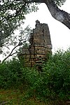
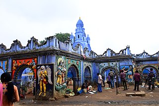
Joypur is a census town in the Joypur CD block in the Jhalda subdivision of the Purulia district in the state of West Bengal, India.

Kotshila is a village, with a police station and a railway junction station, in the Jhalda II CD block in the Jhalda subdivision of the Purulia district in the state of West Bengal, India.

Masina is a village in the Jhalda I CD block in the Jhalda subdivision of the Purulia district in the state of West Bengal, India.

Patardi is a village in the Baghmundi CD block in the Jhalda subdivision of the Purulia district in the state of West Bengal, India.

Baghadih is a village in the Balarampur CD block in the Purulia Sadar subdivision of the Purulia district in the state of West Bengal, India. It is close to Balarampur.

<span class="mw-page-title-main">Jhalda subdivision</span> Subdivision in West Bengal, India

Jhalda subdivision is a subdivision of the Purulia district in the state of West Bengal, India.

Ananda Nagar is a village in the Joypur CD block in the Jhalda subdivision of the Purulia district in the state of West Bengal, India.

Jargo is a village in the Ilu Jargo panchayat in the Jhalda I CD block in the Jhalda subdivision of the Purulia district in the state of West Bengal, India.

Jiudaru is a village in the Jhalda II CD block in the Jhalda subdivision of the Purulia district in the state of West Bengal, India.

Chharra is a village in the Purulia II CD block in the Purulia Sadar subdivision of the Purulia district in the state of West Bengal, India.

<span class="mw-page-title-main">Charida</span> Village in West Bengal, India

Charida is a village in the Baghmundi CD block in the Jhalda subdivision of the Purulia district in the state of West Bengal, India.

Chekya is a census town and a gram panchayat in the Jhalda II CD block in the Purulia Sadar subdivision of the Purulia district in the state of West Bengal, India.

Agharpur is a village in the Joypur CD block in the Jhalda subdivision of the Purulia district in the state of West Bengal, India.

References

  1. "C.D. Block Wise Primary Census Abstract Data(PCA)". West Bengal – District-wise CD Blocks. Registrar General and Census Commissioner, India. Retrieved 21 January 2020.
  2. 1 2 "District Census Handbook, Puruliya, Series 20, Part XII A" (PDF). Suisa - Page 102: Brief Description of Places of Religious, Historical or Archaeological Importance and Places of Tourist Importance of the District. Directorate of Census Operations, West Bengal. Retrieved 21 January 2020.
  3. Houlton, Sir John, Bihar, the Heart of India, 1949, p. 170, Orient Longmans Ltd.
  4. "District Statistical Handbook 2014 Purulia". Tables 2.1, 2.2. Department of Planning and Statistics, Government of West Bengal. Retrieved 12 January 2020.
  5. "Purulia". Department of Tourism. Government of West Bengal. Retrieved 1 February 2020.
  6. "Chhau dance of Purulia". Itsavpedia. Retrieved 1 February 2020.
  7. "District Census Handbook: Puruliya – Series 20, Part Xii A, Census of India 2011" (PDF). Page 102: Brief Description of Places of Religious, Historical or Archaeological Importance and Places of Tourist Interest of the District. Directorate of Census Operations, West Bengal. Retrieved 28 January 2020.
  8. "Archaeological tourist interest". Suisa. District administration. Retrieved 19 January 2020.
  9. "58023 Tatanagar-Barkakhana Passenger". Time Table. IndiaRailInfo. Retrieved 21 January 2020.