Cheliyama

Last updated

Cheliyama
Village
Chelyama
Cheliyama - Radha Gobindo Temple (4).jpg
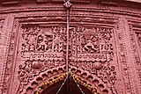
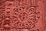
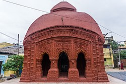
Radha Vinod temple at Cheliyama
West Bengal location map.svg
Red pog.svg
Cheliyama
Location in West Bengal, India
India location map.svg
Red pog.svg
Cheliyama
Cheliyama (India)
Coordinates: 23°37′01.2″N86°33′10.8″E / 23.617000°N 86.553000°E / 23.617000; 86.553000
CountryFlag of India.svg  India
State West Bengal
District Purulia
Population
 (2011)
  Total7,413
Languages
  Official Bengali, English
Time zone UTC+5:30 (IST)
Telephone/STD code03251
Lok Sabha constituency Purulia
Vidhan Sabha constituency Para
Website purulia.gov.in

Cheliyama (also referred to as Cheyama) is a village in the Raghunathpur II CD block in the Raghunathpur subdivision of the Purulia district in the state of West Bengal, India.

Contents

Geography

Cheliyama
Places in Raghunathpur subdivision in Purulia district
M: municipal town, CT: census town, R: rural/ urban centre, H: historical/ religious centre, T: tourist centre
Owing to space constraints in the small map, the actual locations in a larger map may vary slightly

Location

Cheliyama is located at 23°37′01.2″N86°33′10.8″E / 23.617000°N 86.553000°E / 23.617000; 86.553000 .

Area overview

Purulia district forms the lowest step of the Chota Nagpur Plateau. The general scenario is undulating land with scattered hills. [1] Raghunathpur subdivision occupies the northern part of the district. 83.80% of the population of the subdivision lives in rural areas. However, there are pockets of urbanization and 16.20% of the population lives in urban areas. There are 14 census towns in the subdivision. [2] It is presented in the map given alongside. There is a coal mining area around Parbelia [3] and two thermal power plants are there – the 500 MW Santaldih Thermal Power Station [4] and the 1200 MW Raghunathpur Thermal Power Station. The subdivision has a rich heritage of old temples, some of them belonging to the 11th century or earlier. The Banda Deul is a monument of national importance. [5] [6] The comparatively more recent in historical terms, Panchkot Raj has interesting and intriguing remains in the area. [7] [8]

Note: The map alongside presents some of the notable locations in the subdivision. All places marked in the map are linked in the larger full screen map.

Demographics

According to the 2011 Census of India, Cheyama had a total population of 7,413 of which 3,809 (51%) were males and 3,604 (49%) were females. There were 853 persons in the age range of 0–6 years. The total number of literate persons in Cheyama was 4,758 (72.53% of the population over 6 years). [9]

Civic administration

CD block HQ

The headquarters of Raghunathpur II CD block are located at Chelyama. [10]

Transport

The State Highway 8 running from Santaldih (in the Purulia district) to Majhdia (in the Nadia district) passes through Chelyama. [11]

Education

Santaldih College was established in 2008 at Usir, PO Chatarmahul. [12]

Cheleyma Bijoli Prova High School is a Bengali-medium coeducational institution established in 1945. It has facilities for teaching from class V to class XII. It has a library with 2,100 books. [13]

Cheleyama B.C.Girls H.S. High School is a Bengali-medium girls only institution established in 1960. It has facilities for teaching from class V to class XII. [14]

Culture

There is a Radha Vinod temple, dated 1619 Sakabda (around 17th century), at Cheliyama. The richly decorated terracotta depict Krishnalila (divine love of Krishna) and Ramayana scenes. [15]

Achkoda, like Cheliyama, showcases aatchala-style temples with terracotta work on the walls. However, while there has been restoration at Cheliyama, Achkoda remains untouched. [16]

There is an 11th-century rekha deul at Banda, 1 km away. [17]

Terracotta panels in Radha Vinod temple

Healthcare

Banda (Cheliyama) Rural Hospital, with 30 beds at Cheliyama, is the major government medical facility in the Raghunathpur II CD block. [18]

Related Research Articles

Chapari is a census town in the Para CD block in the Raghunathpur subdivision of the Puruliya district in the state of West Bengal, India.

Hijuli is a census town in the Neturia CD block in Raghunathpur subdivision of the Purulia district in the Indian state of West Bengal.

Parbelia is a census town in the Neturia CD block in the Raghunathpur subdivision of the Purulia district in the Indian state of West Bengal.

Santaldih is a census town in the Raghunathpur II CD block in the Raghunathpur subdivision of the Purulia district in the Indian state of West Bengal.

Gobag is a village in the Neturia CD block in the Raghunathpur subdivision of the Purulia district in the state of West Bengal, India.

Nabagram is a census town in the Raghunathpur II CD block in the Raghunathpur subdivision of the Purulia district in West Bengal, India.

Para is a village, with a police station, in the Para CD block in the Raghunathpur subdivision of the Purulia district in West Bengal, India.

Anara is a Town in the Para CD block in the Raghunathpur subdivision of the Purulia district, West Bengal, India, about 14 km from Adra Junction. Anara Railway Station is having 2 platforms for up trains and down trains. Anara has large number of Railway employees mostly Running staff residing in 3 pockets viz. Bungalow side, Old colony and new colony apart from the market area. There is a big railway school and adjacent to it a play ground.

Nituria is a village, with a police station, in the Neturia CD block in the Raghunathpur subdivision of the Purulia district in West Bengal, India.

Kalloli is a village in the Kashipur CD block in the Raghunathpur subdivision of the Purulia district in the state of West Bengal, India. It is close to Kashipur.

Achkoda is a village in the Neturia CD block in the Raghunathpur subdivision of the Purulia district in the state of West Bengal, India.

Haraktor is a village in the Para CD block in the Raghunathpur subdivision of the Purulia district in the state of West Bengal, India.

Usir is a village in the Raghunathpur II CD block in the Raghunathpur subdivision of the Purulia district in the state of West Bengal, India.

Kanki is a census town in the Para CD block in the Raghunathpur subdivision of the Purulia district in the state of West Bengal, India.

Dubra is a census town and a gram panchayat in the Para CD block in the Raghunathpur subdivision of the Purulia district in the state of West Bengal, India.

Shankara is a census town and a gram panchayat in the Para CD block in the Raghunathpur subdivision of the Purulia district in the state of West Bengal, India.

Saltore is a census town and a gram panchayat in the Neturia CD block in the Raghunathpur subdivision of the Purulia district in the state of West Bengal, India.

Murulia is a census town in the Santuri CD block in the Raghunathpur subdivision of the Purulia district in the state of West Bengal, India.

Kantaranguri is a census town in the Kashipur CD block in the Raghunathpur subdivision of the Purulia district in the state of West Bengal, India.

Lapara is a census town in the Kashipur CD block in the Raghunathpur subdivision of the Purulia district in the state of West Bengal, India.

References

  1. Houlton, Sir John, Bihar, the Heart of India, 1949, p. 170, Orient Longmans Ltd.
  2. "District Statistical Handbook 2014 Purulia". Tables 2.1, 2.2. Department of Planning and Statistics, Government of West Bengal. Archived from the original on 21 January 2019. Retrieved 12 January 2020.
  3. "Area wise Closed User Group (CUG) Telephone Numbers" (PDF). Sodepur Area. Eastern Coalfields Limited. Retrieved 11 August 2018.
  4. "Santaldih Thermal Power Station - WBPDCL". WBPDCL. Archived from the original on 11 January 2010. Retrieved 24 August 2011.
  5. "Old temple at Banda (locally known as deul)". ASI, Kolkata Circle. Retrieved 23 January 2020.
  6. "List of Ancient Monuments and Archaeological Sites and Remains of West Bengal - Archaeological Survey of India". Item no. 134. ASI. Retrieved 25 January 2020.
  7. "Capital in shambles: Garh Panchakot, Purulia". Heritage in Peril. Archived from the original on 1 December 2016. Retrieved 1 December 2016.
  8. "Historical ruins". Trek Earth. Retrieved 1 December 2016.
  9. "2011 Census – Primary Census Abstract Data Tables". West Bengal – District-wise. Registrar General and Census Commissioner, India. Retrieved 2 December 2016.
  10. "District Census Handbook: Puruliya" (PDF). Map of District Puruliya with CD block HQs and Police Stations (on the fifth page). Directorate of Census Operations, West Bengal, 2011. Retrieved 2 December 2016.
  11. "List of State Highways in West Bengal". West Bengal Traffic Police. Retrieved 2 December 2016.
  12. "Santaldih College". SC. Retrieved 17 January 2020.
  13. "Cheleyma B.P. School". ICBSE. Retrieved 1 February 2020.
  14. "Cheleyama B.C. Girl's HS High School". ICBSE. Retrieved 1 February 2020.
  15. "Purulia.nic.in". Travel & Tourism Purulia - Cheliama. District administration. Retrieved 23 January 2020.
  16. Gupta, Amitabha. "Rediscover Purulia's Timeless Heritage". Outlook traveller, 22 August 2018. Retrieved 28 January 2020.
  17. "Old temple at Banda (locally known as deul)". ASI, Kolkata Circle. Retrieved 23 January 2020.
  18. "Health & Family Welfare Department" (PDF). Health Statistics – Rural Hospitals. Government of West Bengal. Archived from the original (PDF) on 8 October 2022. Retrieved 18 January 2020.